MEGA-PEARLS Part 3-HABs & More, Bay-Delta Science Conference, April 2021
A Stream of Science Takeaways
ESTUARY News sent reporters to the first virtual Bay-Delta Science Conference in April 2021. This special edition of Pearls shares more than 24 takeaways in four parts (between April 21 & April 29).
PEARLS PART 3: Pesticides, HABs, New Neural Network, Ship Channel, Tule Red, Quake Risk Levees and more

Fish prey species in the Delta are developing resistance to contaminants in agricultural runoff, which can lead to higher contaminant concentrations passing up the food chain. Nadhirah Johanif of the University of Massachusetts, Boston, found that chlorpyrifos, a common insecticide used in agriculture, is causing genetic changes that impart resistance in the freshwater amphipod Hyalella azteca. This allows for higher concentrations of the pesticide to pass up the food chain to Delta fish—and the species that eat them. “Resistant animals… can accumulate higher concentrations of chlorpyrifos in their tissues, up to 50 times more,” Johanif says. Chlorpyrifos, one of several organophosphate pesticides, accumulates in tissues and lipids of organisms, and works as a pesticide by targeting neurological systems. The pesticides are known to affect fish species through endocrine disruption, liver damage, and decreased growth; consumption of prey species with higher concentrations of contaminants can amplify these effects. Chlorpyrifos has been linked to developmental harm in children. Although it is banned for agricultural use in California as of this year, a 2016 federal ban was overturned by the Trump administration and it is still widely used on a range of food crops. ED
Above: Chlorpyrifos resistant H. azteca have been found at locations throughout the Delta.
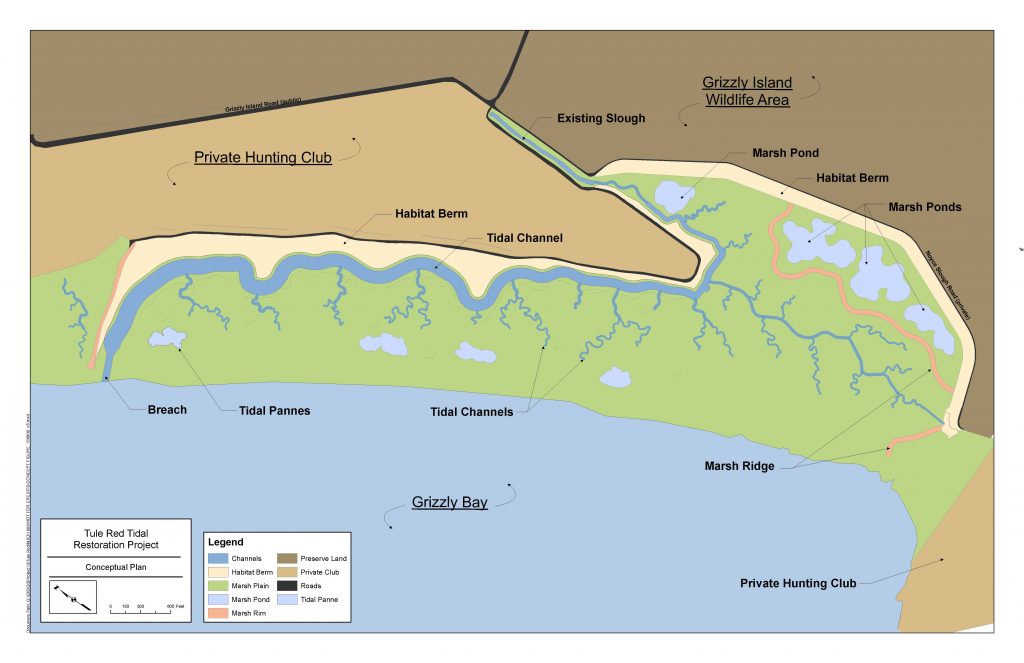
Tidal marsh has returned to Tule Red, and so have the smelt. In October 2019, approximately 400 acres of diked land abutting Grizzly Bay in Suisun Marsh were opened to the tides after being managed for freshwater habitat and duck hunting since the early 1900s. The Tule Red site was restored by Sacramento firm Westervelt Ecological Services in 2018 through the construction of a main channel and network of secondary channels, a series of ponds and pannes in the high marsh, and a perimeter berm to protect neighboring properties and provide transitional habitat for terrestrial species. A year later the existing berm separating Tule Red from the Bay was finally breached. In her conference talk, Ramona Swenson, restoration ecology program manager for project partner Environmental Science Associates , presented results of the first year of monitoring efforts at Tule Red—including the exciting discovery of larval longfin smelt in the main channel. Scientists also sampled chlorophyll levels as a measure of primary productivity in a pond, the main channel, and Grizzly Bay. They found levels to be highest in the pond, which floods approximately every two weeks at spring tides, suggesting that the longer residence time of water in the pond resulted in greater productivity. “The pattern is tantalizing, so we’re hoping that with further monitoring in the coming years we’ll be able to get a little more information,” Swenson said. “Not only is some of this productivity from the pond getting into the channel, but fish are coming into the site and can take advantage of that.” NS
Above: Tule Red restoration project courtesy Ramona Swenson
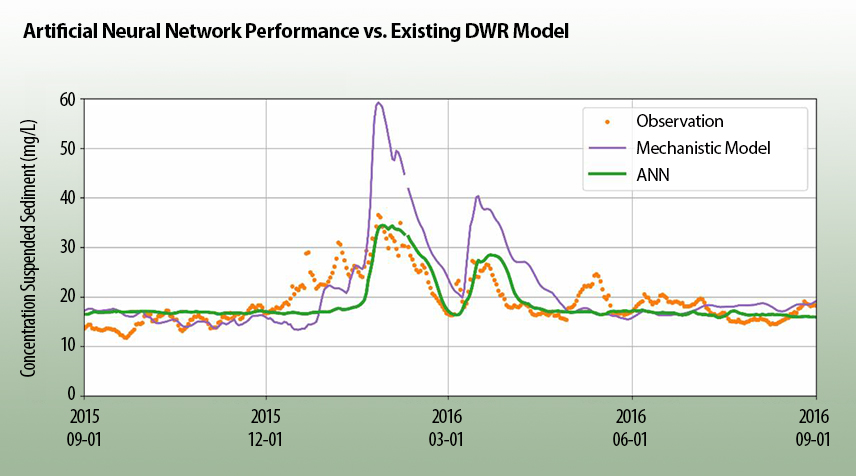
A new artificial neural network developed by engineers simulates Delta sediment transportation as well or better than the existing California Department of Water Resources model. Sophisticated models of water and sediment-flow across the Delta’s floodplain may adequately simulate some parts of the Delta, but not others. So Han Sang Kim and his collaborators Nicky Sandhu and Kevin He at DWR decided to try a new approach: Let a machine do the work. They used an artificial neural network (essentially a computing system of loosely arranged grouped nodes, similar to neurons in the brain) to model suspended sediment transportation in the Delta. They plugged in real-life measurements from field stations across the Delta and let the machine “learn” the best relationship between the water flow and sediment, without trying to force one using the physical equations that govern water flow. After first “training” the neural network with five years of daily data taken from monitoring stations around the Delta, the artificial network found a more efficient fit to the data than DWR’s existing sediment transport model built by engineers, with less or similar error. However, due to the mystery of how the artificial neural network solved the relationship, Kim isn’t quite ready to throw out the traditional mechanistic models. “As machine learning tools are largely a ‘black box’ approach, I personally think that it is too early to have full confidence in machine learning,” he said. He noted the neural network’s results can help refine the existing DWR model by showing there is a more accurate pathway to modeling suspended sediment—they just have to figure out if and how the real world physics and fluid mechanics allow it. IP
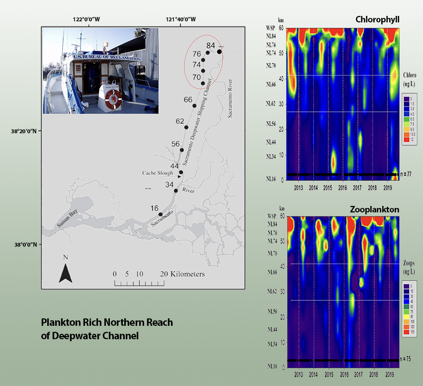
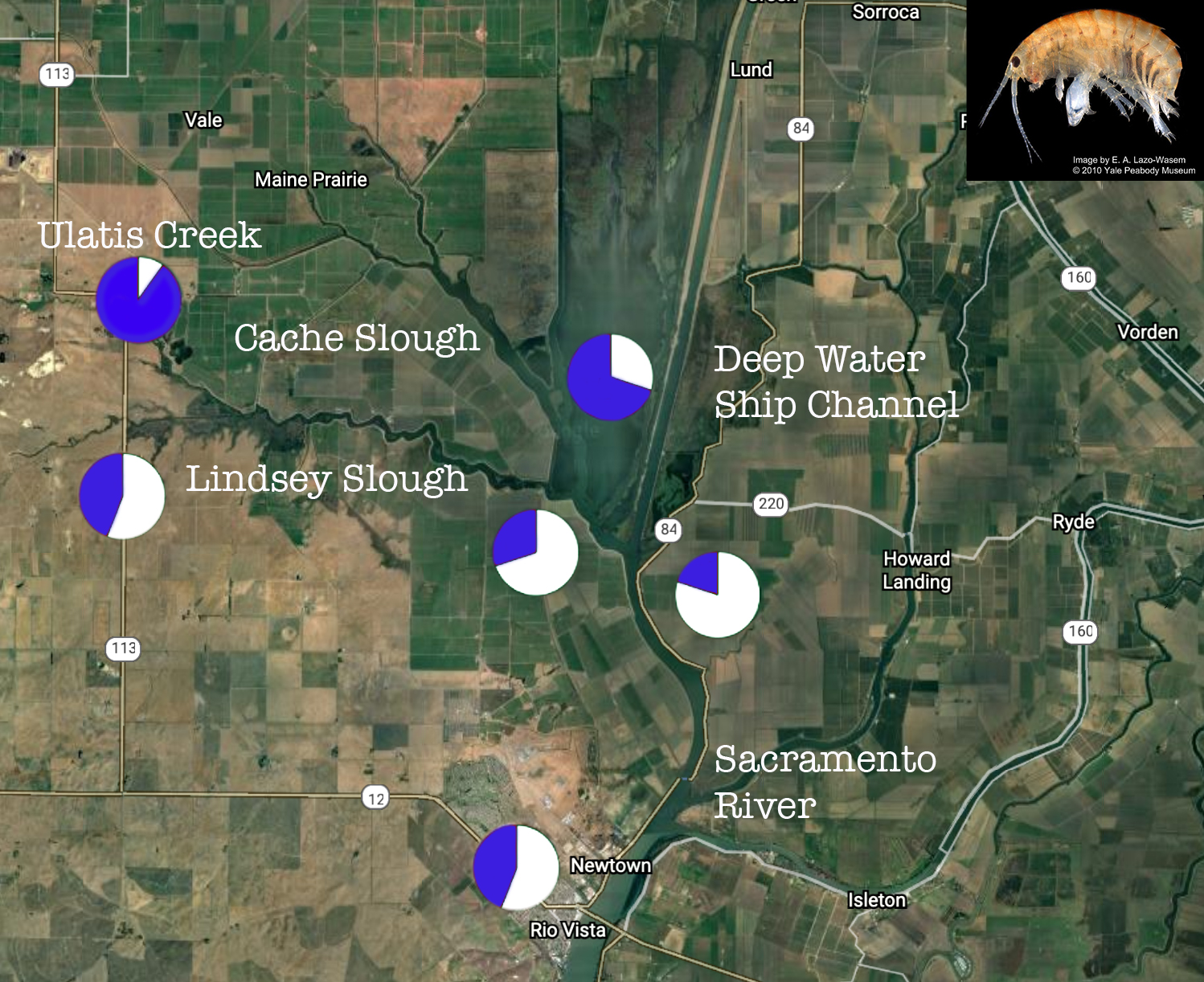
The Sacramento Deep Water Ship Channel produces more fish food and shelters more smelt than many other Delta waterways, but big changes may be coming. Cut off for decades from the Sacramento River, the channel somewhat resembles the dead-end sloughs common in the pre-reclamation Delta. Since 2009, researchers have been working to parse the secrets of its productivity and find ways to boost it even more. “The channel is great because it’s a pretty controlled laboratory,” the US Geological Survey’s Matthew Young told the conference during a special session on the channel. Studies have found differing food webs in three distinct zones: a southern one with much tidal exchange; a central one with muted tides and a lot of turbidity, which is favored by smelt; and a lake-like northern zone where daily temperature stratification occurs and phytoplankton flourish (see chart, above). A pending plan to reconnect the channel to the river at West Sacramento would reshuffle the deck with unknown consequences. In another talk during the same session, Erwin Van Nieuwenhuyse of the US Bureau of Reclamation noted laconically: “We have to do quite a bit more research.” JH
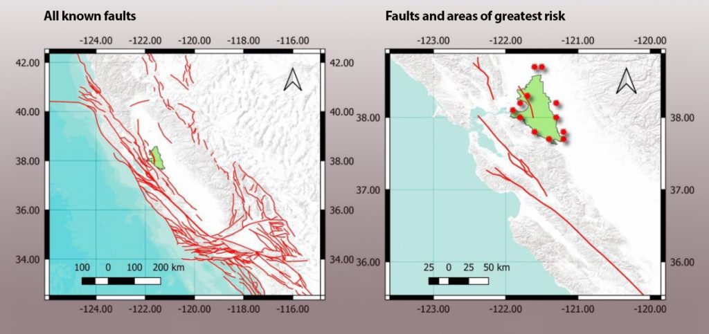
A novel, more focused approach to analyzing earthquake risks faced by Delta levees could be used to update hazard maps, prioritize repairs and improvements, and reduce the chance of failure on an island-by-island basis. A UCLA team is currently conducting a pilot study using its newly developed method to assess seismic risk at Bacon Island, midway between Antioch and Stockton. Uniform hazard maps are commonly used to assess earthquake risks across specific areas, and form the basis for seismic hazard analysis in building codes. But they’re not appropriate for analyzing spatially distributed infrastructure systems like levees, team leader Scott Brandenberg explained in his conference presentation. Instead, his team’s new method takes a more targeted approach and accounts for the interconnected nature of levee systems. It begins with an algorithm to narrow down the list of hundreds of thousands of specific “scenario events,” potential earthquakes that might occur on any of the various faults veining the region. “Once you have that reduced set of scenario events, [for each event] you can figure out the ground shaking intensity levels…at each spot along an island, and then figure out the probability of failure of each reach by assigning it a fragility function, and then combine all of those reach probabilities of failure to get the probability of failure of an island,” Brandenberg said. “A levee system is a series system, so we’re trying to find the weakest link in the chain.” The team intends to apply the statistical framework behind the method to other hazards facing Delta levees like flooding, subsidence, and sea-level rise. NS
Above: Red dots represent potential earthquake locations on unknown faults (likely to be smaller, but still of concern for levee failure because of their proximity to the Delta).
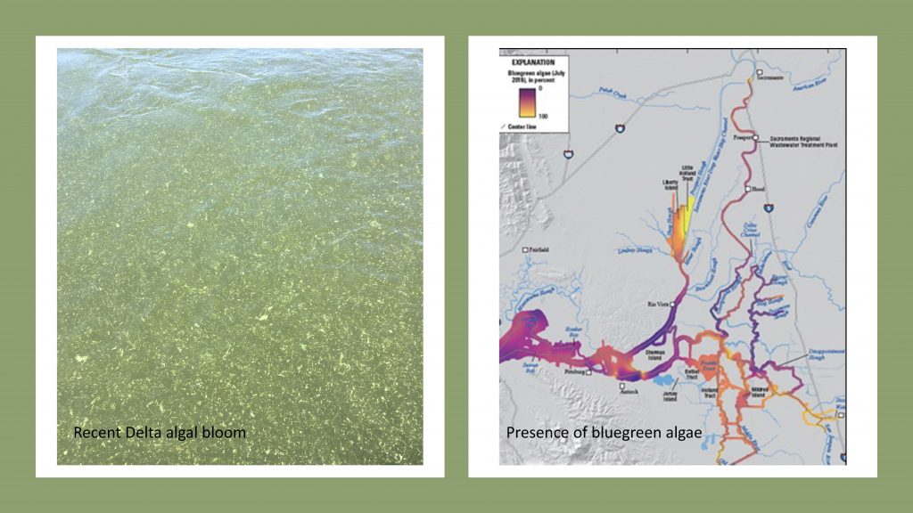
Harmful Algal Blooms (HABs), prolific growths of toxic algae, may shift from a seasonal challenge to a year-round problem in the Delta. Associated with a range of impacts to human health and the environment, they can cause mass fish and shellfish die-offs, poison pets, and cause respiratory distress–even death–in humans. Meghan Klasic, of the Center for Environmental Policy and Behavior at UC Davis, studies the particular challenges of governance in watersheds seeking to manage this issue. “What makes HABs management so difficult but interesting to study is the disjointedness between where the HABs occur… and where the inputs originate, further upstream.” The problematic nitrogen and phosphorus inputs come from myriad sources, including agriculture, industry, and urban areas. The inputs combine with warm temperatures to result in the overgrowth of toxin-producing cyanobacteria. Climate change is extending warmer temperatures, producing the conditions that support HABs for more months of the year. Klasic points out that the United States and Canada have been collaboratively managing Lake Erie HABs since the early 1970s. She hopes that lessons learned from their experiences can be applied to other complex systems, emphasizing collaboration and communication between government groups, industrial sources, and other institutions. This information can help inform efforts to monitor HABs in the Delta, which does not yet have a formal monitoring program. ED

Editor: Cariad Hayes Thronson
Contributors: Nate Seltenrich, Isaac Pearlman, John Hart, Elyse DeFranco
Produced in collaboration with the Delta Stewardship Council.
The Bay-Delta Science Conference presents the work of hundreds of scientists and summarizes gigabytes of data. The editors of this small stream of takeaways acknowledge the larger river of work and wish they could have covered more sessions and more science. Keep us in your loop for future Pearls and Estuary News stories.
Read Part 4-Climate, Bay


 The results are alarming for our state’s future: an estimated four to five feet of sea level rise and loss of one to two-thirds of Southern California beaches by 2100, a 50 percent increase in wildfires over 25,000 acres, stronger and longer heat waves, and infrastructure like airports, wastewater treatment plants, rail and roadways increasingly likely to suffer flooding.