San Francisco’s vulnerability to sea level rise is no secret. Entire neighborhoods are built on fill, only feet above current sea level. But just like Treasure Island and the rapidly developing Mission Bay neighborhood, less visible parts of the city — the pipes and plants that collect, treat, and whisk away San Francisco’s stormwater and sewage — are also at risk. And this critical infrastructure could face a double hit from climate change in the coming decades: more severe storms dumping excess rainwater into the system on one end, and rising sea levels and storm surges inundating pipes and facilities on the other. “If wastewater starts flowing into the streets or into people’s homes, people are going to get upset really quickly,” says Pacific Institute senior research associate Matt Heberger, who coauthored a 2009 report outlining likely impacts of sea level rise on the Pacific Coast. The problem isn’t confined to San Francisco and its combined wastewater and stormwater system.
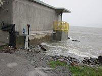
King tides at the furthest land accessible point on EBMUD’s Bay outfall, a structure not usually surrounded by water. Photo courtesy EBMUD.
According to the Pacific Institute report, 22 Bay Area wastewater treatment plants discharging a total of 350 million gallons per day could be at least partially inundated by a 100-year flood event with 4.6 feet of sea level rise, which most current projections agree could happen by 2100. The region’s five largest wastewater plants, processing 60 to 70 percent of our wastewater, are all located within a few hundred yards of the shore, says Mike Connor of the East Bay Dischargers Authority (EBDA). Still, the Pacific Institute’s analysis provides only a rough picture of potential impacts on wastewater infrastructure in the Bay Area, says Heberger. It’s likely that plants that now appear to be at risk would later be protected by levees or seawalls. It’s also likely that plants at higher elevations could still be affected if their pipes, storage facilities, or other components become flooded, whether routinely or from isolated storm surges and king tides. Possible outcomes include accelerated corrosion of pipes from saltwater, reverse flows of bay water into outfall pipes toward plants and other facilities, reduced flow capacity of outfall pipes damage to electrical components, and release of sewage and hazardous or toxic materials as treatment plants, storage tanks, and other facilities are inundated or compromised. “Even if the footprint of the plant looks good, the pipeline and its ability to discharge may be vulnerable,” says Sarah Richmond, a planner with the San Francisco Bay Conservation and Development Commission (BCDC). “So you’ve got these cascading vulnerabilities that you’re looking at.” Potential solutions are equally diverse. They include adding new gates to pipe ends that prevent backflows, relocating pipes or facilities, discharging treated wastewater to upland areas of marshes instead of directly to the Bay, expanding recycled-water programs so that less water must be discharged, developing decentralized systems to distribute risk, replacing concrete pipes with less corrodible plastic pipes, and building old-fashioned levees, sand-bag barriers, and concrete ramps to protect sensitive facilities from extreme events.
With so many impacts and solutions on the table, it can be difficult to know where to start — especially since scientists still aren’t sure how far the water will rise or when. Add to that the high cost of replacing wastewater infrastructure and its long lifespan, in some cases 100 years or more, and planning becomes even more of a challenge. Local wastewater authorities are in the early stages of thinking about it, supported in part California Climate Ready grants and regional research efforts like the Adapting to Rising Tides (ART) project. “All the agencies are going around finding what heights all their facilities are, and which things they need most to worry about, and how they might protect them,” says Connor. But immediate retrofits are unlikely; instead, the preferred approach at EBDA, the East Bay Municipal Utilities District (EBMUD), the San Francisco Public Utilities Commission (SFPUC), and elsewhere appears to be to integrate sea level rise resilience into long-term maintenance and capital-improvement plans. Practically speaking, Connor says, the big question is this: “How do we build sea level rise concerns into our design while we’re simultaneously dealing with other issues?”
According to EBMUD spokesperson Abby Figueroa, “All of the climate change concerns are something that the district has tried to build into its long-term planning. As [pipes and facilities] get upgraded, thinking ahead, how do you make them last for another 50 to 100 years?” David Behar, climate program director for the SFPUC, says the city’s recently adopted sea level rise guidance document outlines how to incorporate climate adaption planning into infrastructure and capital-improvement projects — without prescribing specific solutions. “If you’re investing in assets that are going to last 100 years, the picture of climate change 100 years from now is all over the map,” he says. “What you need to do is account for what is prudent to plan for today while understanding what the long-term worst-case scenario might be.” The SFPUC is already beginning to witness how sea level rise could impair its 29 discharge pipes and stormwater overflow points on the Bay. “What we’ve begun to see now in a way that is a nuisance but not yet a major problem is backflow of saline water from the Bay into those overflow points,” Behar says. “And we know that’s going to go from being a nuisance to a problem, because sea level rise is only going in one direction.”
Nate Seltenrich is a freelance science and environmental journalist who covers infrastructure, restoration, and related topics for Estuary. He also contributes to the San Francisco Chronicle, Sonoma and Marin magazines, the journal Environmental Health Perspectives, and other local and national publications, on subjects ranging from public lands and renewable energy to the human health impacts of climate change. He lives in Petaluma with his wife, two boys, and four ducks. www.nate-reports.com
Our magazine’s media motto for many years has been “Where there’s an estuary, there’s a crowd.” The San Francisco Estuary is a place where people, wildlife, and commerce congregate, and where watersheds, rivers and the ocean meet and mix, creating a place of unusual diversity. In choosing to tell the...
Ever since the state and federal water projects were built in the 1930s and 1940s, California has captured snowmelt in foothill reservoirs, and moved the fresh water from dam releases and river outflows to parched parts of the state via aqueducts hundreds of miles long. A convoluted system of ancient...
Though the Clean Water Act did an amazing job of reducing wastewater and stormwater pollution of the San Francisco Estuary, some contaminants remain thorny problems. Legacy pollutants like mercury washed into the watershed from upstream gold mining, PCBs from old industrial sites, and selenium from agricultural drainage in the San...
Hothouse Earth
By Ariel Rubissow Okamoto
Photo by Megan Nguyen
Nothing could be stranger than sitting in the dark with thousands of suits and heels, watching a parade of promises to decarbonize from companies and countries large and small, reeling from the beauties of big screen rainforests and indigenous necklaces, and getting all choked up.
It was day two of the September 2018 Global Climate Action Summit in San Francisco when I felt it.
At first I wondered if I was simply starstruck. Most of us labor away trying to fix one small corner of the planet or another without seeing the likes of Harrison Ford, Al Gore, Michael Bloomberg, Van Jones, Jerry Brown – or the ministers or mayors of dozens of cities and countries – in person, on stage and at times angry enough to spit. And between these luminaries a steady stream of CEOs, corporate sustainability officers, and pension fund managers promising percentages of renewables and profits in their portfolios dedicated to the climate cause by 2020-2050.
I tried to give every speaker my full attention: the young man of Vuntut Gwichin heritage from the edge of the Yukon’s Arctic National Wildlife Refuge who pleaded with us not to enter his sacred lands with our drills and dependencies; all the women – swathed in bright patterns and head-scarfs – who kept punching their hearts. “My uncle in Uganda would take 129 years to emit the same amount of carbon as an American would in one year,” said Oxfam’s Winnie Byanyima.
“Our janitors are shutting off the lights you leave on,” said Aida Cardenas, speaking about the frontline workers she trains, mostly immigrants, who are excited to be part of climate change solutions in their new country.
The men on the stage, strutting about in feathers and pinstripes, spoke of hopes and dreams, money and power. “The notion that you can either do good or do well is a myth we have to collectively bust,” said New Jersey Governor Phil Murphy whose state is investing heavily in offshore wind farms.
“Climate change isn’t just about risks, it’s about opportunities,” said Blackrock sustainable investment manager Brian Deese.
But it wasn’t all these fine speeches that started the butterflies. Halfway through the second day of testimonials, it was a slight white-haired woman wrapped in an azure pashmina that pricked my tears. One minute she was on the silver screen with Alec Baldwin and the next she taking a seat on stage. She talked about trees. How trees can solve 30% of our carbon reduction problem. How we have to stop whacking them back in the Amazon and start planting them everywhere else. I couldn’t help thinking of Dr. Seuss and his truffala trees. Jane Goodall, over 80, is as fierce as my Lorax. Or my daughter’s Avatar.
Analyzing my take home feeling from the event I realized it wasn’t the usual fear – killer storms, tidal waves, no food for my kids to eat on a half-baked planet – nor a newfound sense of hope – I’ve always thought nature will get along just fine without us. What I felt was relief. People were actually doing something. Doing a lot. And there was so much more we could do.
As we all pumped fists in the dark, as the presentations went on and on and on because so many people and businesses and countries wanted to STEP UP, I realized how swayed I had let myself be by the doomsday news mill.
“We must be like the river, “ said a boy from Bangladesh named Risalat Khan, who had noticed our Sierra watersheds from the plane. “We must cut through the mountain of obstacles. Let’s be the river!”
Or as Harrison Ford less poetically put it: “Let’s turn off our phones and roll up our sleeves and kick this monster’s ass.”
4th California Climate Change Assessment Blues
by Isaac Pearlman
Since California’s last state-led climate change assessment in 2012, the Golden State has experienced a litany of natural disasters. This includes four years of severe drought from 2012 to 2016, an almost non-existent Sierra Nevada snowpack in 2014-2015 costing $2.1 billion in economic losses, widespread Bay Area flooding from winter 2017 storms, and extremely large and damaging wildfires culminating with this year’s Mendocino Complex fire achieving the dubious distinction of the largest in state history. California’s most recent climate assessment, released August 27th, predicts that for the state and the Bay Area, we can expect even more in the future.
The California state government first began assessing climate impacts formally in 2006, due to an executive order by Governor Schwarzenegger. California’s latest iteration and its fourth overall, includes a dizzying array of 44 technical reports; three topical studies on climate justice, tribal and indigenous communities, and the coast and ocean; as well as nine region-specific analyses.
The results are alarming for our state’s future: an estimated four to five feet of sea level rise and loss of one to two-thirds of Southern California beaches by 2100, a 50 percent increase in wildfires over 25,000 acres, stronger and longer heat waves, and infrastructure like airports, wastewater treatment plants, rail and roadways increasingly likely to suffer flooding.
For the first time, California’s latest assessment dives into climate consequences on a regional level. Academics representing nine California regions spearheaded research and summarized the best available science on the variable heat, rain, flooding and extreme event consequences for their areas. For example, the highest local rate of sea level rise in the state is at the rapidly subsiding Humboldt Bay. In San Diego county, the most biodiverse in all of California, preserving its many fragile and endangered species is an urgent priority. Francesca Hopkins from UC Riverside found that the highest rate of childhood asthma in the state isn’t an urban smog-filled city but in the Imperial Valley, where toxic dust from Salton Sea disaster chokes communities – and will only become worse as higher temperatures and less water due to climate change dry and brittle the area.
According to the Bay Area Regional Report, since 1950 the Bay Area has already increased in temperature by 1.7 degrees Fahrenheit and local sea level is eight inches higher than it was one hundred years ago. Future climate will render the Bay Area less suitable for our evergreen redwood and fir forests, and more favorable for tolerant chaparral shrub land. The region’s seven million people and $750 billion economy (almost one-third of California’s total) is predicted to be increasingly beset by more “boom and bust” irregular wet and very dry years, punctuated by increasingly intense and damaging storms.
Unsurprisingly, according to the report the Bay Area’s intensifying housing and equity problems have a multiplier affect with climate change. As Bay Area housing spreads further north, south, and inland the result is higher transportation and energy needs for those with the fewest resources available to afford them; and acute disparity in climate vulnerability across Bay Area communities and populations.
“All Californians will likely endure more illness and be at greater risk of early death because of climate change,” bluntly states the statewide summary brochure for California’s climate assessment. “[However] vulnerable populations that already experience the greatest adverse health impacts will be disproportionately affected.”
“We’re much better at being reactive to a disaster than planning ahead,” said UC Berkeley professor and contributing author David Ackerly at a California Adaptation Forum panel in Sacramento on August 27th. “And it is vulnerable communities that suffer from those disasters. How much human suffering has to happen before it triggers the next round of activity?”
The assessment’s data is publicly available online at “Cal-adapt,” where Californians can explore projected impacts for their neighborhoods, towns, and regions.


 The results are alarming for our state’s future: an estimated four to five feet of sea level rise and loss of one to two-thirds of Southern California beaches by 2100, a 50 percent increase in wildfires over 25,000 acres, stronger and longer heat waves, and infrastructure like airports, wastewater treatment plants, rail and roadways increasingly likely to suffer flooding.