The Pajaro Valley enjoys a temperate
microclimate, in part because it is situated at the hip of Monterey Bay. It
lays like an east-west-oriented horseshoe, with the open end settling around the coastal
plains of Elkhorn Slough and its various tributaries and side sloughs. Rimmed by the Santa Cruz
Mountains to the north, the Gabilan Range to the south, and the San Andreas
Fault at its head, the
Pajaro Valley is
a unique place in California.
Marks from the state’s past — traces of the
indigenous creekside camps to the Mission landmarks and Gold Rush-era place-names — tell part of the
valley’s story. Unlike
in neighboring areas that
have embraced the commuting car culture, the endless lines of perfectly aligned
row crops reveal that this valley is still very much a working landscape.
But the Pajaro Valley is different from the rest of the big ag regions in California. The
loamy soil isn’t irrigated with massive surface water infrastructure like in
the Central Valley. “There are no federal or state water projects here,” says
Marcus Mendiola, a water conservation and outreach specialist with the Pajaro
Valley Water Management Agency. Nevertheless, the 28,500 acres of well-tended
crops in the lower Pajaro watershed are planted in what is considered among the
most valuable agricultural land on the planet.
The farms that create the economic
engine of Pajaro Valley operate at different scales. Some growers are small, while others have labels
you might recognize from the grocery store:
Martinellis,
Driscolls, California Giant, to name a few. Regardless of the amount of acreage
under management, one thing that the farmers (and all residents, for that
matter) share is that most of their water
comes from the ground.
How to best handle the area’s
diminishing supply of groundwater has occupied local water managers for
decades. “People have been documenting groundwater concerns here since the
1950s,” says Mendiola. But improvements to conservation and infrastructure — funded in part by
California’s 18-year old Integrated Regional Water Management program — have bolstered the
valley’s chances of thriving in the face of future stresses like climate change
and seawater intrusion.
Early strawberries growing near PV Water’s Harkins Slough recharge basin. Photo: Daniel McGlynn
Strawberry fields forever
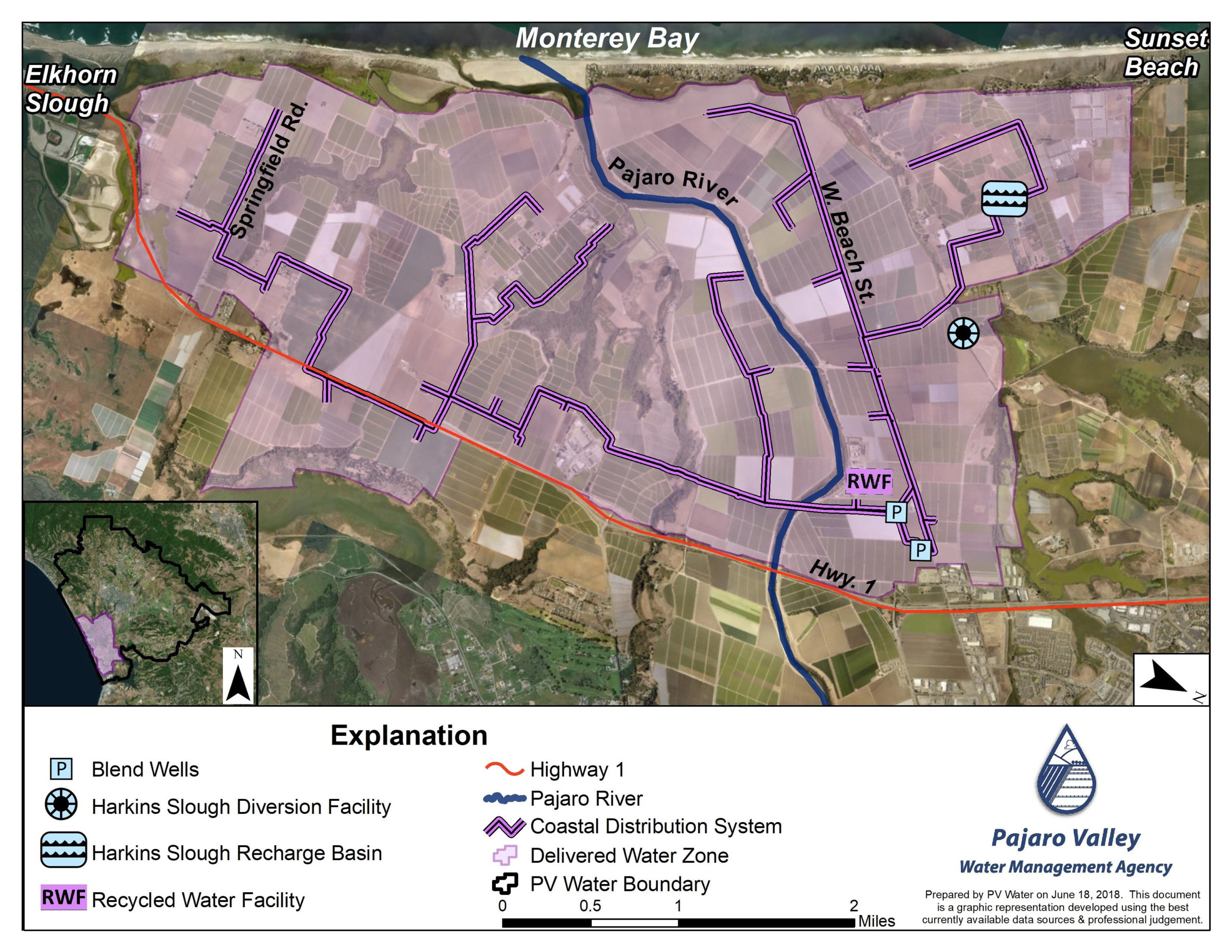
Like cairns that show the way on a faint trail, the coastal
distribution pipeline operated by the Pajaro Valley Water Management Agency and
serving 5,000 acres of prime farmland is marked every so often by turnouts. The
turnouts pop above ground as six-to-eight-inch-diameter pipe and then
bend at 90 degrees. They are affixed with a series of valves (and usage meters,
which are in the process of being converted from hand-read manual meters to
digital meters). The turnouts allow irrigators to connect to a vast system of
water infrastructure managed by the agency, known locally as PV Water.
PV Water was created in 1984 by state
charter to deal with the valley’s diminishing water supply. The agency is
solely focused on the conservation and management of groundwater for
irrigation, which accounts for 85 percent of the water demand in the valley.
“The entire geology of this area is like
a layer cake,” says Mendiola. Historically, the recharge rate of the
layer-cake-like aquifer used to keep pace with the withdrawal rate. So much so
that valley old-timers remember when wells near the coast would run artesian,
which means that the aquifer was so full that when tapped, water would come to
the surface without pumping, Mendiola says. But in more recent decades in the
Pajaro Valley, like in much of California, the demand for water has exceeded
the supply, meaning the level of available water in the aquifer was continually
receding.
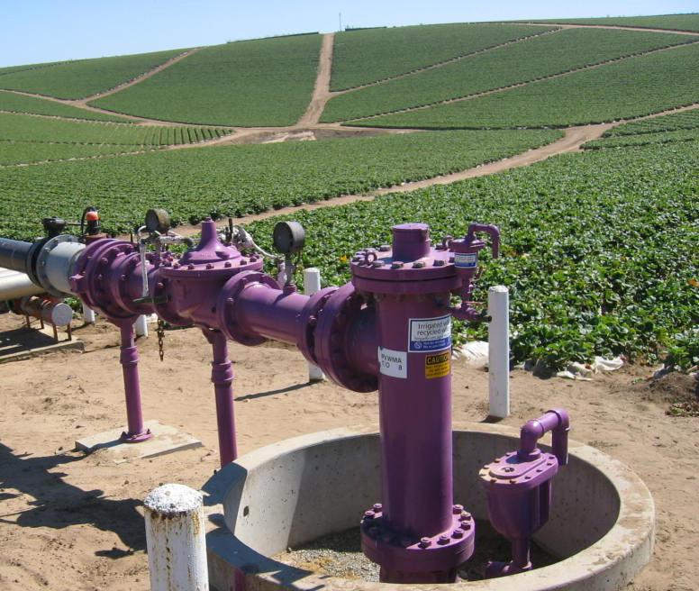
Coastal distribution system for recycled water.
The color of PV Water’s turnouts and
wellheads along the 21 miles of the coastal distribution pipeline system is
significant. Blue paint means that the valves connect to a well underneath the
ground. The health of these wells —
both quality and quantity (salinity is a major concern) — is managed through
recharge efforts. For the past two decades, PV Water has been experimenting with new ways of increasing natural recharge
(or allowing water to percolate through the ground, which filters the water and
raises the level of the underlying aquifer) across its jurisdiction.
In 2002, one of PV Water’s first major
infrastructure projects came online. They retrofitted equipment that Santa Cruz
County once used to dewater
cropland and now use
it to pump water —
permitted up to 2,000 acre-feet a year and only when the water quality and
quantity meet certain thresholds —
into a recharge basin a mile-and-a-half away. This time of year, ducks love the
recharge pond, which is in the middle of what feels like endless fields of
just-ripening strawberries. Underground it’s refilling local aquifers. “After
all, the best and most efficient place to store water,” Mendiola says, “is
underground.”
Here and there on the horizon,
purple turnouts are visible. Purple means the
water is coming from a recycling facility. Opened in 2009, and continually
improved since, the Watsonville Area Water Recycling Facility helps PV Water
manage for both agricultural output and a healthy aquifer. By using water
recycled from Watsonville’s municipal wastewater plant, the agency is able to
offset some of the demand for groundwater. “The groundwater creates a
hydrostatic barrier, which prevents further seawater
intrusion,” Mendiola
says.
As an added benefit, further treating
water coming from the wastewater facility and sending it back to the fields as high-quality,
non-potable water reduces the need to send the nutrient-rich water through a
discharge pipe into Monterey Bay. For the last 14 years, PV Water has been
monitoring nutrient loading of soil and groundwater in their recycled water
delivery area. “We have not observed a negative impact to the soils from
recycled water deliveries,” Mendiola says.
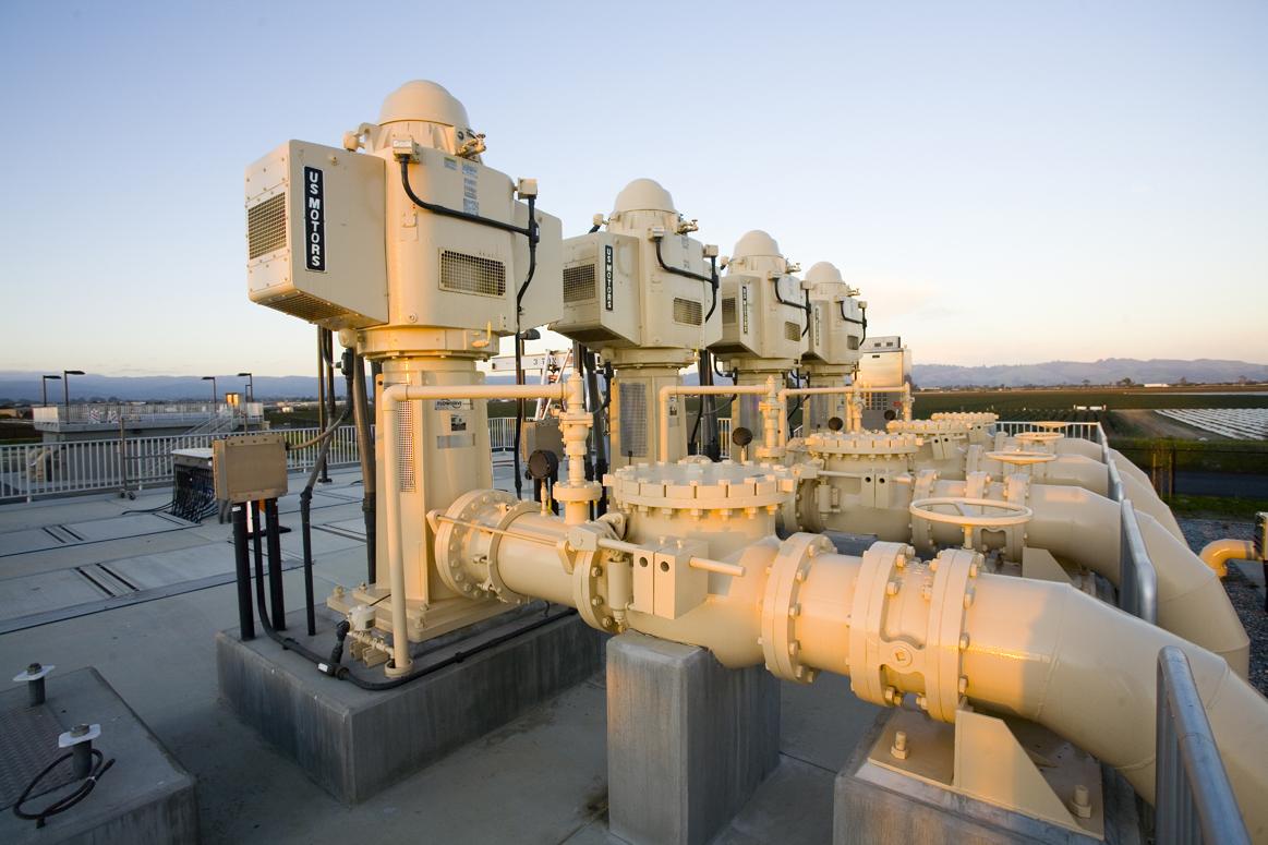
The Watsonville Area Water Recycling Facility, which is operated by PV water can recycle as many as 1.1 billion gallons of water a year. Photo: PV Water
The water diverted into the recycling
facility averages about 57 percent (or about 6,000 acre feet) of Watsonville’s
wastewater over the course of a year. During peak dry times as much as 100
percent of Watsonville’s discharge is recycled according to Mendiola. In three
concrete structures, the recycled water goes through additional processing
steps including more solid separation, filtration, and disinfection, and
blended with other water sources before entering PV Water’s coastal
distribution system and made available to irrigators.
The system has worked so well that it was expanded in 2014
to include an additional 1.5-million-gallon storage tank to
keep up with demand. The new tank,
as well as the recycling facility itself (which today is under construction to
add additional filtration), was funded in part because recurring droughts led
California to make a priority of promoting more integrated regional water
management in the early 2000s.
When reach exceeds grasp
First launched in 2002, Integrated
Regional Water Management (IRWM)
alleviates some of the burden of
managing California’s complicated water situation. A collaborative effort led by the Department
of Water Resources, IRWM
is an organizational structure designed to
get water-related funding earmarked via bond measures prioritized and delivered
to water-related projects around the state. So far, the department has awarded $1.5
billion in IRWM grants for
infrastructure, education, conservation, and access.
A blue recovery well that pumps water adjacent to the Harkins Slough recharge basin. Photo: Daniel McGlynn
The goal is to better coordinate
water-related expertise, data, and funding across jurisdictional, watershed, and political
boundaries to concurrently
achieve social, environmental, and economic benefits, explains James Muller,
principal environmental planner with the San Francisco Estuary Partnership and
the grant manager for 39 projects under three IRWM grants in the Bay Area.
IRWM divides the state into 12 funding
regions that are allocated a discrete share of the total IRWM funding made
available by bond propositions. The
Department of Water Resources solicits proposals from
these funding regions that must meet an
arduous
set of eligibility criteria.
The Watsonville Area Recycling Center
received several rounds of funding under Proposition 84 including $4.7 million to build the
coastal distribution pipeline, $6.8 million to build the recycled water
facility, and $900,000 to build the 1.5-million-gallon storage tank.
While the money did help get those projects built, IRWM funds represent only a
portion of the total construction and maintenance costs for most large-scale
projects. “You also see projects that would never happen unless they were
funded by a program like IRWM,” says Muller.
“It’s been good,” says Brian Lockwood, general manager of PV Water, about the IRWM process.
“It’s definitely developed increased collaboration. It makes you think and work
together at a more regional scale, instead of only working in your own box.”
And the work continues. While Lockwood
is concerned that the tap of IRWM funds might not be flowing as steadily as in
previous years, the agency is still using IRWM money to expand the availability
of recycled water for irrigation.
In Pajaro Valley, PV Water will break
ground soon on an addition to the coastal delivery system, bringing more
recycled water to more farms to the north. The project is funded by $3 million
in IRWM funds. “We’ll be able to add two miles to our 21 miles of the existing
coastal distribution pipeline,” Lockwood says.
Daniel McGlynn worked as an itinerant naturalist, trip leader, and wilderness guide before serving as an environmental educator with the Peace Corps in rural Nicaragua. Realizing that storytelling is a great educational tool, and productive way to inspire understanding and change, he then turned his attention to science and environmental writing. He is an alum of UC Berkeley’s Graduate School of Journalism and his work has appeared in a handful of national publications. He frequently writes about infrastructure projects and restoration work for Estuary News. Connect with him at danielmcglynn.com.
Our magazine’s media motto for many years has been “Where there’s an estuary, there’s a crowd.” The San Francisco Estuary is a place where people, wildlife, and commerce congregate, and where watersheds, rivers and the ocean meet and mix, creating a place of unusual diversity. In choosing to tell the...
Ever since the state and federal water projects were built in the 1930s and 1940s, California has captured snowmelt in foothill reservoirs, and moved the fresh water from dam releases and river outflows to parched parts of the state via aqueducts hundreds of miles long. A convoluted system of ancient...
Though the Clean Water Act did an amazing job of reducing wastewater and stormwater pollution of the San Francisco Estuary, some contaminants remain thorny problems. Legacy pollutants like mercury washed into the watershed from upstream gold mining, PCBs from old industrial sites, and selenium from agricultural drainage in the San...
Hothouse Earth
By Ariel Rubissow Okamoto
Photo by Megan Nguyen
Nothing could be stranger than sitting in the dark with thousands of suits and heels, watching a parade of promises to decarbonize from companies and countries large and small, reeling from the beauties of big screen rainforests and indigenous necklaces, and getting all choked up.
It was day two of the September 2018 Global Climate Action Summit in San Francisco when I felt it.
At first I wondered if I was simply starstruck. Most of us labor away trying to fix one small corner of the planet or another without seeing the likes of Harrison Ford, Al Gore, Michael Bloomberg, Van Jones, Jerry Brown – or the ministers or mayors of dozens of cities and countries – in person, on stage and at times angry enough to spit. And between these luminaries a steady stream of CEOs, corporate sustainability officers, and pension fund managers promising percentages of renewables and profits in their portfolios dedicated to the climate cause by 2020-2050.
I tried to give every speaker my full attention: the young man of Vuntut Gwichin heritage from the edge of the Yukon’s Arctic National Wildlife Refuge who pleaded with us not to enter his sacred lands with our drills and dependencies; all the women – swathed in bright patterns and head-scarfs – who kept punching their hearts. “My uncle in Uganda would take 129 years to emit the same amount of carbon as an American would in one year,” said Oxfam’s Winnie Byanyima.
“Our janitors are shutting off the lights you leave on,” said Aida Cardenas, speaking about the frontline workers she trains, mostly immigrants, who are excited to be part of climate change solutions in their new country.
The men on the stage, strutting about in feathers and pinstripes, spoke of hopes and dreams, money and power. “The notion that you can either do good or do well is a myth we have to collectively bust,” said New Jersey Governor Phil Murphy whose state is investing heavily in offshore wind farms.
“Climate change isn’t just about risks, it’s about opportunities,” said Blackrock sustainable investment manager Brian Deese.
But it wasn’t all these fine speeches that started the butterflies. Halfway through the second day of testimonials, it was a slight white-haired woman wrapped in an azure pashmina that pricked my tears. One minute she was on the silver screen with Alec Baldwin and the next she taking a seat on stage. She talked about trees. How trees can solve 30% of our carbon reduction problem. How we have to stop whacking them back in the Amazon and start planting them everywhere else. I couldn’t help thinking of Dr. Seuss and his truffala trees. Jane Goodall, over 80, is as fierce as my Lorax. Or my daughter’s Avatar.
Analyzing my take home feeling from the event I realized it wasn’t the usual fear – killer storms, tidal waves, no food for my kids to eat on a half-baked planet – nor a newfound sense of hope – I’ve always thought nature will get along just fine without us. What I felt was relief. People were actually doing something. Doing a lot. And there was so much more we could do.
As we all pumped fists in the dark, as the presentations went on and on and on because so many people and businesses and countries wanted to STEP UP, I realized how swayed I had let myself be by the doomsday news mill.
“We must be like the river, “ said a boy from Bangladesh named Risalat Khan, who had noticed our Sierra watersheds from the plane. “We must cut through the mountain of obstacles. Let’s be the river!”
Or as Harrison Ford less poetically put it: “Let’s turn off our phones and roll up our sleeves and kick this monster’s ass.”
4th California Climate Change Assessment Blues
by Isaac Pearlman
Since California’s last state-led climate change assessment in 2012, the Golden State has experienced a litany of natural disasters. This includes four years of severe drought from 2012 to 2016, an almost non-existent Sierra Nevada snowpack in 2014-2015 costing $2.1 billion in economic losses, widespread Bay Area flooding from winter 2017 storms, and extremely large and damaging wildfires culminating with this year’s Mendocino Complex fire achieving the dubious distinction of the largest in state history. California’s most recent climate assessment, released August 27th, predicts that for the state and the Bay Area, we can expect even more in the future.
The California state government first began assessing climate impacts formally in 2006, due to an executive order by Governor Schwarzenegger. California’s latest iteration and its fourth overall, includes a dizzying array of 44 technical reports; three topical studies on climate justice, tribal and indigenous communities, and the coast and ocean; as well as nine region-specific analyses.
The results are alarming for our state’s future: an estimated four to five feet of sea level rise and loss of one to two-thirds of Southern California beaches by 2100, a 50 percent increase in wildfires over 25,000 acres, stronger and longer heat waves, and infrastructure like airports, wastewater treatment plants, rail and roadways increasingly likely to suffer flooding.
For the first time, California’s latest assessment dives into climate consequences on a regional level. Academics representing nine California regions spearheaded research and summarized the best available science on the variable heat, rain, flooding and extreme event consequences for their areas. For example, the highest local rate of sea level rise in the state is at the rapidly subsiding Humboldt Bay. In San Diego county, the most biodiverse in all of California, preserving its many fragile and endangered species is an urgent priority. Francesca Hopkins from UC Riverside found that the highest rate of childhood asthma in the state isn’t an urban smog-filled city but in the Imperial Valley, where toxic dust from Salton Sea disaster chokes communities – and will only become worse as higher temperatures and less water due to climate change dry and brittle the area.
According to the Bay Area Regional Report, since 1950 the Bay Area has already increased in temperature by 1.7 degrees Fahrenheit and local sea level is eight inches higher than it was one hundred years ago. Future climate will render the Bay Area less suitable for our evergreen redwood and fir forests, and more favorable for tolerant chaparral shrub land. The region’s seven million people and $750 billion economy (almost one-third of California’s total) is predicted to be increasingly beset by more “boom and bust” irregular wet and very dry years, punctuated by increasingly intense and damaging storms.
Unsurprisingly, according to the report the Bay Area’s intensifying housing and equity problems have a multiplier affect with climate change. As Bay Area housing spreads further north, south, and inland the result is higher transportation and energy needs for those with the fewest resources available to afford them; and acute disparity in climate vulnerability across Bay Area communities and populations.
“All Californians will likely endure more illness and be at greater risk of early death because of climate change,” bluntly states the statewide summary brochure for California’s climate assessment. “[However] vulnerable populations that already experience the greatest adverse health impacts will be disproportionately affected.”
“We’re much better at being reactive to a disaster than planning ahead,” said UC Berkeley professor and contributing author David Ackerly at a California Adaptation Forum panel in Sacramento on August 27th. “And it is vulnerable communities that suffer from those disasters. How much human suffering has to happen before it triggers the next round of activity?”
The assessment’s data is publicly available online at “Cal-adapt,” where Californians can explore projected impacts for their neighborhoods, towns, and regions.


 The results are alarming for our state’s future: an estimated four to five feet of sea level rise and loss of one to two-thirds of Southern California beaches by 2100, a 50 percent increase in wildfires over 25,000 acres, stronger and longer heat waves, and infrastructure like airports, wastewater treatment plants, rail and roadways increasingly likely to suffer flooding.