
 A recent survey found that 80 percent of Californians don’t know anything about the Sacramento-San Joaquin River Delta. It’s a stark example of why museum curators, scientists, and environmental planners packed Tuesday afternoon’s session, “Sharing our Stories: Interpreting the Estuary.” In the case of the Delta, asked moderator and climate change consultant Will Travis, “how can we tell compelling stories about something the public can’t find, because they don’t know what to look for, why it’s worth finding, and what it is if they stumble upon it?”
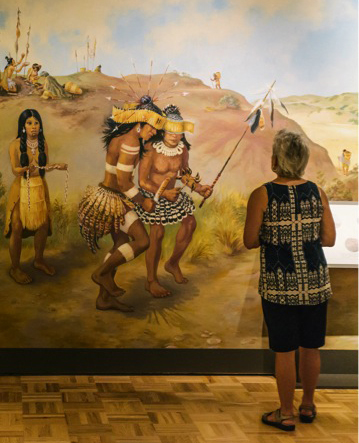
Chuck Striplen, an environmental scientist at the San Francisco Estuary Institute reminded the audience of the value of adding cultural landscapes, especially those from Native Americans, to public information about the Bay. According to Striplen, to fully understand the Bay as a cultural landscape, we need to build trust and promote collaborative research with local Indian tribes. “Humans have transformed the physical and ecological systems of the Bay throughout its history. Over that time, tribes accumulated tremendous knowledge and experience,” he said. As evidence of this relationship, Striplen cited the shoreline shellmounds that archeologists excavated in the 1900s. The mounds are the result of more than 5,000 years of continuous human habitation on the Bay’s edge. “They contain physical evidence of people’s stories—their food, ceremonies, tools, arts—and they have great potential to help us understand biodiversity, disturbance response, baseline populations, and distributions of hundreds of species,” said Striplen. “There remains much to be learned about the whole human experience of this place from the remnants still in the ground and in the minds of living tribal people. This history still has value in understanding how the world works and how it could work,” he said. The Oakland Museum of California’s interpretive exhibit about the Emeryville Shellmound is a fine example of how to share this knowledge with the public, Striplen said. “The mounds are presented not as stale, musty collections of stone and shell artifacts, but instead focus on the builders—who they were and how they lived and how the families were and are connected to this place,” said Striplen.
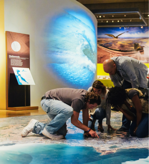
The shellmound exhibit is part of the museum’s latest major show, “Above and Below: Stories from the Changing Bay.” The next two speakers discussed how staff from the museum and the San Francisco Estuary Institute worked together to bring Bay history to life. “We wanted to approach this heavily urbanized estuary not as a place where there is no nature, but as a place where people have had many different relationships with nature over time—a place that is the product of both human intervention and engineering and also the natural world and natural processes that are still current and active,” said Louise Pubols, a senior curator of history at the museum of California. Pubols described the origins of the Bay Bridge portion of the show, which includes not just its construction challenges but also the experiences of commuters and bridge workers. CalTrans sponsored the exhibit to help satisfy mitigation responsibilities for the demolition of the bridge’s eastern span as required by state and federal law for the destruction of large landmark structures. The exhibit’s many interactive items include a giant satellite image of the Bay covering the floor (“Everyone looks for their house,” said Publos); pieces of the bridge, cannonballs that have washed up on Angel Island; and a wall covered with jars of contaminated Bay water. “We tried to think about ways to convey information without putting the book on the wall,” said Publos. “No one will stand there and read five paragraphs of ten-point text. You have to catch their eye and trick them to read stuff.”
Museum staff worked closely with the San Francisco Estuary Institute to integrate science into the show. “To the Oakland Museum staff, our attempt at simplifying information must have seemed anything but,” said Ruth Askevold, senior project manager at the Institute. “SFEI often tells its stories in detailed technical reports. We had to learn how to translate our complex reports, charts, and tables into captions suitable for museum displays.” She exhorted scientists to work harder to get the public excited about the Bay through storytelling. “Stories are one of the best ways humans, including scientists, understand, pass down, and preserve our collective knowledge. When they are done well, we walk away with a framework that helps us remember. And because stories usually involve living things, they give us a way to connect to a place and to each other,” she said.
The next speaker, the Delta Protection Commission’s Alex Westhoff, discussed the concept of the “Delta as place” and the need to share these site-specific stories. “The Chinese proverb, ‘When you drink water, consider the fountain,’ rings true when applied to the Delta,” he said. To help ensure that the Sacramento-San Joaquin River Delta’s unique cultural and natural resources are protected, he said, Senator Dianne Feinstein and Representative John Garamendi have proposed designating the Delta a National Heritage Area. “While its importance as a water supplier for California cannot be understated, that is just a portion of the Delta’s story,” said Westhoff. “What about the stories of the Delta as a cultural landscape? The stories of the Miwok Indians who inhabited the riverbanks prior to the Spanish missionaries? Of the Chinese immigrants who hand-built the first set of Delta levees using wheel brigades? Of the fourth-generation farming families who continue to grow crops on the same lands that their great grandparents did?”
Photographs are another powerful way for people to connect with place. Anthea M. Hartig, the California Historical Society’s executive director, talked about her organization’s “Year of the Bay” collaboration with the website Historypin. The project allows people to upload and geotag photographs. In a little less than a year, she said, approximately 2,500 pieces of original material, mostly photographs, have been added to the site. “The broader hope of the project was that participants would help generate useful, accurate, meaningful metadata for archival sources,” Hartig explained, supplementing historic documents that have with little or no identifying information. She added, “The history of the Bay has long been dominated by relatively hegemonic standard environmental narrative. We hoped that our project would enhance, enrich, and even complicate that narrative. In the end, it comes down to garnering our stories, one beautiful person at a time.”
Oakland Museum Changing Bay Exhibit
Year of the Bay
Delta Protection Commission
Big Break
[toggle_box]
[toggle_item title=”PowerPoint Gallery” active=”false”]


NEXT ARTICLE: Scaling up from Reach to Region
By Ariel Rubissow Okamoto

Nothing could be stranger than sitting in the dark with thousands of suits and heels, watching a parade of promises to decarbonize from companies and countries large and small, reeling from the beauties of big screen rainforests and indigenous necklaces, and getting all choked up.
It was day two of the September 2018 Global Climate Action Summit in San Francisco when I felt it.
At first I wondered if I was simply starstruck. Most of us labor away trying to fix one small corner of the planet or another without seeing the likes of Harrison Ford, Al Gore, Michael Bloomberg, Van Jones, Jerry Brown – or the ministers or mayors of dozens of cities and countries – in person, on stage and at times angry enough to spit. And between these luminaries a steady stream of CEOs, corporate sustainability officers, and pension fund managers promising percentages of renewables and profits in their portfolios dedicated to the climate cause by 2020-2050.
I tried to give every speaker my full attention: the young man of Vuntut Gwichin heritage from the edge of the Yukon’s Arctic National Wildlife Refuge who pleaded with us not to enter his sacred lands with our drills and dependencies; all the women – swathed in bright patterns and head-scarfs – who kept punching their hearts. “My uncle in Uganda would take 129 years to emit the same amount of carbon as an American would in one year,” said Oxfam’s Winnie Byanyima.
“Our janitors are shutting off the lights you leave on,” said Aida Cardenas, speaking about the frontline workers she trains, mostly immigrants, who are excited to be part of climate change solutions in their new country.
The men on the stage, strutting about in feathers and pinstripes, spoke of hopes and dreams, money and power. “The notion that you can either do good or do well is a myth we have to collectively bust,” said New Jersey Governor Phil Murphy whose state is investing heavily in offshore wind farms.
“Climate change isn’t just about risks, it’s about opportunities,” said Blackrock sustainable investment manager Brian Deese.
But it wasn’t all these fine speeches that started the butterflies. Halfway through the second day of testimonials, it was a slight white-haired woman wrapped in an azure pashmina that pricked my tears. One minute she was on the silver screen with Alec Baldwin and the next she taking a seat on stage. She talked about trees. How trees can solve 30% of our carbon reduction problem. How we have to stop whacking them back in the Amazon and start planting them everywhere else. I couldn’t help thinking of Dr. Seuss and his truffala trees. Jane Goodall, over 80, is as fierce as my Lorax. Or my daughter’s Avatar.
Analyzing my take home feeling from the event I realized it wasn’t the usual fear – killer storms, tidal waves, no food for my kids to eat on a half-baked planet – nor a newfound sense of hope – I’ve always thought nature will get along just fine without us. What I felt was relief. People were actually doing something. Doing a lot. And there was so much more we could do.
As we all pumped fists in the dark, as the presentations went on and on and on because so many people and businesses and countries wanted to STEP UP, I realized how swayed I had let myself be by the doomsday news mill.
“We must be like the river, “ said a boy from Bangladesh named Risalat Khan, who had noticed our Sierra watersheds from the plane. “We must cut through the mountain of obstacles. Let’s be the river!”
Or as Harrison Ford less poetically put it: “Let’s turn off our phones and roll up our sleeves and kick this monster’s ass.”
by Isaac Pearlman
Since California’s last state-led climate change assessment in 2012, the Golden State has experienced a litany of natural disasters. This includes four years of severe drought from 2012 to 2016, an almost non-existent Sierra Nevada snowpack in 2014-2015 costing $2.1 billion in economic losses, widespread Bay Area flooding from winter 2017 storms, and extremely large and damaging wildfires culminating with this year’s Mendocino Complex fire achieving the dubious distinction of the largest in state history. California’s most recent climate assessment, released August 27th, predicts that for the state and the Bay Area, we can expect even more in the future.
The California state government first began assessing climate impacts formally in 2006, due to an executive order by Governor Schwarzenegger. California’s latest iteration and its fourth overall, includes a dizzying array of 44 technical reports; three topical studies on climate justice, tribal and indigenous communities, and the coast and ocean; as well as nine region-specific analyses.
 The results are alarming for our state’s future: an estimated four to five feet of sea level rise and loss of one to two-thirds of Southern California beaches by 2100, a 50 percent increase in wildfires over 25,000 acres, stronger and longer heat waves, and infrastructure like airports, wastewater treatment plants, rail and roadways increasingly likely to suffer flooding.
For the first time, California’s latest assessment dives into climate consequences on a regional level. Academics representing nine California regions spearheaded research and summarized the best available science on the variable heat, rain, flooding and extreme event consequences for their areas. For example, the highest local rate of sea level rise in the state is at the rapidly subsiding Humboldt Bay. In San Diego county, the most biodiverse in all of California, preserving its many fragile and endangered species is an urgent priority. Francesca Hopkins from UC Riverside found that the highest rate of childhood asthma in the state isn’t an urban smog-filled city but in the Imperial Valley, where toxic dust from Salton Sea disaster chokes communities – and will only become worse as higher temperatures and less water due to climate change dry and brittle the area.
According to the Bay Area Regional Report, since 1950 the Bay Area has already increased in temperature by 1.7 degrees Fahrenheit and local sea level is eight inches higher than it was one hundred years ago. Future climate will render the Bay Area less suitable for our evergreen redwood and fir forests, and more favorable for tolerant chaparral shrub land. The region’s seven million people and $750 billion economy (almost one-third of California’s total) is predicted to be increasingly beset by more “boom and bust” irregular wet and very dry years, punctuated by increasingly intense and damaging storms.
Unsurprisingly, according to the report the Bay Area’s intensifying housing and equity problems have a multiplier affect with climate change. As Bay Area housing spreads further north, south, and inland the result is higher transportation and energy needs for those with the fewest resources available to afford them; and acute disparity in climate vulnerability across Bay Area communities and populations.
“All Californians will likely endure more illness and be at greater risk of early death because of climate change,” bluntly states the statewide summary brochure for California’s climate assessment. “[However] vulnerable populations that already experience the greatest adverse health impacts will be disproportionately affected.”
“We’re much better at being reactive to a disaster than planning ahead,” said UC Berkeley professor and contributing author David Ackerly at a California Adaptation Forum panel in Sacramento on August 27th. “And it is vulnerable communities that suffer from those disasters. How much human suffering has to happen before it triggers the next round of activity?”
The assessment’s data is publicly available online at “Cal-adapt,” where Californians can explore projected impacts for their neighborhoods, towns, and regions.