
 To some, the Bay’s tributary creeks are primarily nurseries for fish; to others, they’re potential flood emergencies affecting multiple cities and counties. Both perspectives, one focused on an individual waterway, the other concerned with the welfare of the region, are useful ways of viewing the functionality and health of a watershed. In Wednesday afternoon’s “Scaling up to Sustainable Watershed Management” session, speakers looked at watersheds from angles ranging from the reach to the region, and considered how each scale addresses different aspects of watershed management.
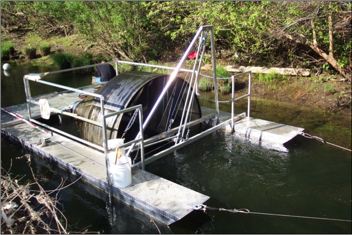
Jonathan Koehler of the Napa County Resource Conservation District focused his talk on the stream level, analyzing how steelhead use the Napa River. The Napa has been designated an anchor watershed for steelhead (Onchorhynchus mykiss) and is second only to the Sacramento/San Joaquin system in stream miles accessible to the seagoing trout. Using a rotary screw trap to detain passing fish, Koehler’s agency and its partners have monitored outbound migrant steelhead in the Napa River system since 2009.
Their data shows steelhead traffic peaks in early April and increases during storm flows. Napa River steelhead smolts, or juveniles, have been relatively large, predicting good ocean survival. Catch rates have remained consistent despite rainfall variations between sampling years. The picture is less encouraging for Chinook salmon. “Abundance has fluctuated substantially during the past five years of monitoring, suggesting that the Napa River population is relatively small and unstable,” Koehler said. This year the conservation district began a passive integrated transponder (PIT) tagging program, using an antenna in the lower river to automatically register the passage of any fish implanted with an electronic identifier tag. The fish monitoring program helps demonstrate when the fish need strong flows, where smolts are hatching in the watershed, and how fish passage and marsh restoration projects affect fish populations, Koehler said. “This unprecedented effort has demonstrated the value of current, scientifically-sound, fisheries data to policy makers and provides a baseline by which we can measure the long-term ecological effects of ongoing restoration work.”
In a presentation that dovetailed with Koehler’s, Gordon Becker of the Center for Ecosystem Management and Restoration (CEMAR) discussed how smolt outmigrant monitoring can identify high growth habitat for steelhead. Trapping has helped pinpoint these areas and inform restoration efforts targeted at specific reaches within a stream. While prime habitat areas for steelhead face continuing threats, there’s potential for expanding the availability of such habitat and improving its quality. “With smolt trapping data from various Bay Area watersheds, we can better define the high-quality habitat that we’re most interested in protecting,” Becker noted. “The greatest numbers of steelhead smolts appear to derive from stream reaches with higher, perennial flows. These areas should form the focus of an overall program to protect the highest productivity aquatic habitats around the Bay Area.” The data could direct attention to previously unexamined streams and encourage regional planning for conservation and rehabilitation of aquatic habitat. Becker suggested that issues like dry season flow impairment and channel and bank modifications might be best addressed at the stream reach scale. A reach-scale approach would also help focus limited resources and be more likely to generate visible success stories.
The scale of the stream reach is also useful in evaluating the health of an entire watershed. Just as a doctor examines blood pressure and body temperature to assess the overall well-being of a patient, watershed managers can study stream reaches as indicators of how well the watershed as a whole functions. Josh Collins of the San Francisco Estuary Institute explained how reach-scale tools like the Wetland and Riparian Area Monitoring Plan (WRAMP) can help meet the challenges of assessing watershed health. WRAMP helps managers design an ideal version of their watershed by answering a single question: how much of what ecosystem services are needed when and where and why? To do so, WRAMP organizes environmental science and information technology into a comprehensive approach for planning, permitting, and evaluation of watershed health. All of these elements are viewed as progress toward integrated goals for flood control, water supply, water quality, cultural resource protection, and wildlife conservation. Wetland Tracker, the Surface Water Ambient Monitoring Program (SWAMP), and Our Coast Our Future are other helpful parts of the watershed manager’s toolkit. “Successful ecosystem health care depends on knowing the target levels of the key services, organizing activities at all levels of government to achieve the targets, monitoring progress toward the targets, and adjusting them for new scientific understanding based on the monitoring results,” Collins explained. Monitoring, he added, “can also help fine-tune the conceptual models that are needed for program planning and the numerical models needed for forecasting ecosystem responses.” He concluded with the idea that watershed science and technology need to be tightly coupled to a system of coordinated government programs that translate the science into effective watershed health care.
In a region as highly urbanized as the Bay Area, inviting local governments to the watershed planning table is not only a good idea, but produces a better plan at the end, according to Josh Bradt of the San Francisco Estuary Partnership. Comprehensive watershed planning by local government “promotes improved watershed health and function by identifying multi-benefit solutions and funding strategies” he says. “Municipal and county governments are uniquely positioned to be anchors of watershed planning and management.” Bradt noted local governments have many watershed responsibilities, such as public health and safety, environmental protection, infrastructure maintenance, as well as common concerns such as undersized and deteriorating stormwater infrastructure, increasing regulatory requirements, staff and budget constraints. Developing a watershed management plan for the city of Berkeley involved an analysis of existing policies, programs, and assets, and hydrologic modeling of two of the city’s watersheds—one still mostly natural, the other a paved-over “ghost drainage.” The plan’s recommendations carried an estimated $83 million price tag for those two watersheds, with work on the remaining eight watersheds within city boundaries costing an estimated additional $125 million. “One challenge was to identify how green infrastructure would complement existing gray infrastructure, and not compete with it for limited capital, operations and maintenance, and staff resources,” Bradt explained. Green infrastructure, he said, not only increases resiliency to climate change but beautifies communities and neighborhoods, improves the curb appeal of residential properties, and fosters pedestrian safety. Funding sources for watershed plan implementation could come from a combination of local tax measures, greenhouse gas reduction funds, vehicle license fees, and state water bonds.

The institutional setting of watershed management matters, according to UC Berkeley’s Louise Mozingo. The Bay Area’s water agencies have a diversity of mandates in terms of water supply, water treatment, flood control, and environmental policy. Innovative urban water strategies such as greenstreets, conjunctive water management, water recycling, decentralized water treatment bioreactors, and unit process wetlands have been implemented within an existing, highly fragmented system. Even though coordination and overlap can be problematic, multiple jurisdictions do lend themselves to experimentation. The public also has a stake and a voice, expressed in a multitude of friends-of-creeks groups. “Community advocacy has focused on surface water systems, on place-making,” Monzingo said, “yet we need to think of water supply, water treatment, and surface water as a single resource system.” While recognizing that change in watershed management is still “an accretion of local decisions,” she’d like to see place-making extended to “science-based systemic problem solving with regional benefits.” To do this, jurisdictional fragmentation problems and complexities need to be addressed. Although the Integrated Regional Watershed Management Plan is a step in this process, coordinated regional water resource management still faces significant institutional obstacles.
Closing the session, California Water Resources Control Board member Steven Moore discussed the status and future of integrated water management. The Integrated Regional Water Management legislation of 2002 helped bring institutionally isolated functions like water supply, pollution control, groundwater supply, and stream and wetland restoration together in a regional context. However, Moore said, IRWM has serious limitations; it is “match-funded by voter-approved bonds that are an unreliable source of public funding going forward, and is implemented by a fragmented governance structure lacking needed flexibility for revenue generation and expenditures.” One solution might be voluntary groupings of public agencies and private organizations throughout a watershed or basin that are endowed with revenue-raising powers. Said Moore, “Regional unified water authorities could build on partnerships and experiences of existing integrated water agencies to improve the governance for all aspects of water, ensuring California can meet its sustainability goals into the twenty-first century.”
State Wetland Monitoring
San Francisquito Creek
CEMAR
[toggle_box]
[toggle_item title=”PowerPoint Gallery” active=”False”]

br>
 [/toggle_item]
[/toggle_box]
[/toggle_item]
[/toggle_box]
By Ariel Rubissow Okamoto

Nothing could be stranger than sitting in the dark with thousands of suits and heels, watching a parade of promises to decarbonize from companies and countries large and small, reeling from the beauties of big screen rainforests and indigenous necklaces, and getting all choked up.
It was day two of the September 2018 Global Climate Action Summit in San Francisco when I felt it.
At first I wondered if I was simply starstruck. Most of us labor away trying to fix one small corner of the planet or another without seeing the likes of Harrison Ford, Al Gore, Michael Bloomberg, Van Jones, Jerry Brown – or the ministers or mayors of dozens of cities and countries – in person, on stage and at times angry enough to spit. And between these luminaries a steady stream of CEOs, corporate sustainability officers, and pension fund managers promising percentages of renewables and profits in their portfolios dedicated to the climate cause by 2020-2050.
I tried to give every speaker my full attention: the young man of Vuntut Gwichin heritage from the edge of the Yukon’s Arctic National Wildlife Refuge who pleaded with us not to enter his sacred lands with our drills and dependencies; all the women – swathed in bright patterns and head-scarfs – who kept punching their hearts. “My uncle in Uganda would take 129 years to emit the same amount of carbon as an American would in one year,” said Oxfam’s Winnie Byanyima.
“Our janitors are shutting off the lights you leave on,” said Aida Cardenas, speaking about the frontline workers she trains, mostly immigrants, who are excited to be part of climate change solutions in their new country.
The men on the stage, strutting about in feathers and pinstripes, spoke of hopes and dreams, money and power. “The notion that you can either do good or do well is a myth we have to collectively bust,” said New Jersey Governor Phil Murphy whose state is investing heavily in offshore wind farms.
“Climate change isn’t just about risks, it’s about opportunities,” said Blackrock sustainable investment manager Brian Deese.
But it wasn’t all these fine speeches that started the butterflies. Halfway through the second day of testimonials, it was a slight white-haired woman wrapped in an azure pashmina that pricked my tears. One minute she was on the silver screen with Alec Baldwin and the next she taking a seat on stage. She talked about trees. How trees can solve 30% of our carbon reduction problem. How we have to stop whacking them back in the Amazon and start planting them everywhere else. I couldn’t help thinking of Dr. Seuss and his truffala trees. Jane Goodall, over 80, is as fierce as my Lorax. Or my daughter’s Avatar.
Analyzing my take home feeling from the event I realized it wasn’t the usual fear – killer storms, tidal waves, no food for my kids to eat on a half-baked planet – nor a newfound sense of hope – I’ve always thought nature will get along just fine without us. What I felt was relief. People were actually doing something. Doing a lot. And there was so much more we could do.
As we all pumped fists in the dark, as the presentations went on and on and on because so many people and businesses and countries wanted to STEP UP, I realized how swayed I had let myself be by the doomsday news mill.
“We must be like the river, “ said a boy from Bangladesh named Risalat Khan, who had noticed our Sierra watersheds from the plane. “We must cut through the mountain of obstacles. Let’s be the river!”
Or as Harrison Ford less poetically put it: “Let’s turn off our phones and roll up our sleeves and kick this monster’s ass.”
by Isaac Pearlman
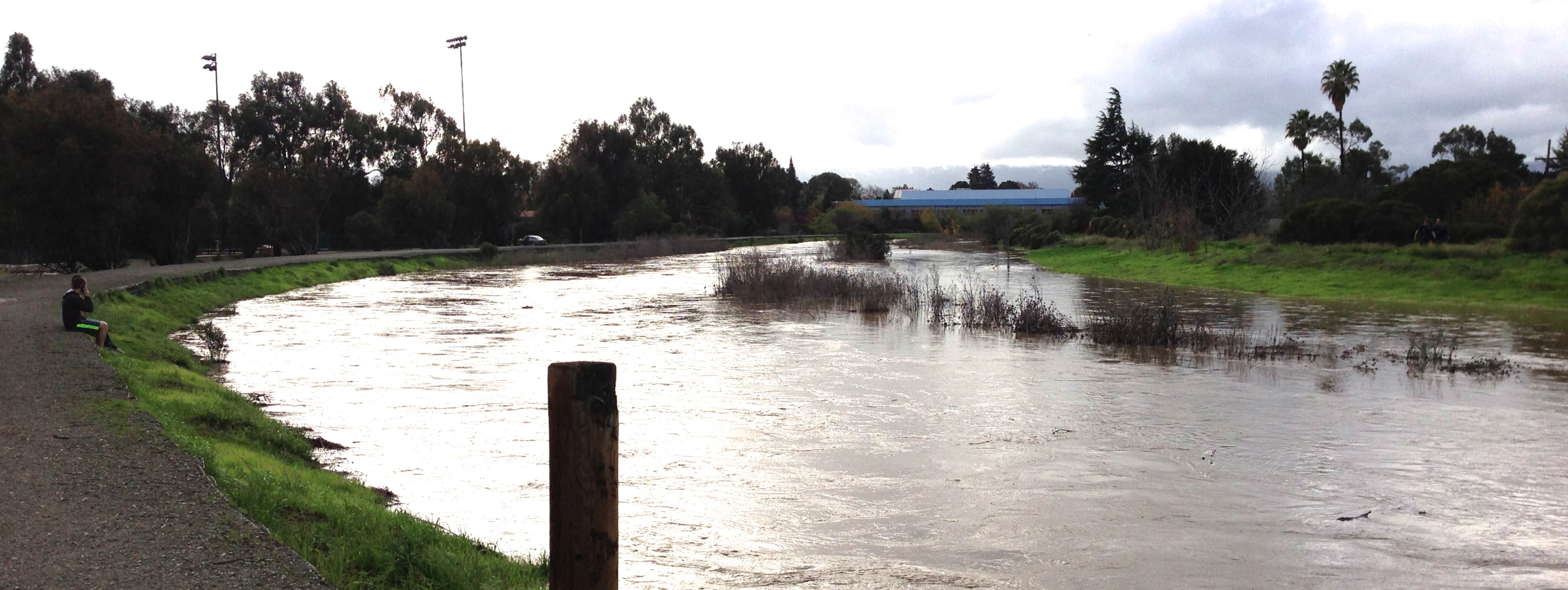
Since California’s last state-led climate change assessment in 2012, the Golden State has experienced a litany of natural disasters. This includes four years of severe drought from 2012 to 2016, an almost non-existent Sierra Nevada snowpack in 2014-2015 costing $2.1 billion in economic losses, widespread Bay Area flooding from winter 2017 storms, and extremely large and damaging wildfires culminating with this year’s Mendocino Complex fire achieving the dubious distinction of the largest in state history. California’s most recent climate assessment, released August 27th, predicts that for the state and the Bay Area, we can expect even more in the future.
The California state government first began assessing climate impacts formally in 2006, due to an executive order by Governor Schwarzenegger. California’s latest iteration and its fourth overall, includes a dizzying array of 44 technical reports; three topical studies on climate justice, tribal and indigenous communities, and the coast and ocean; as well as nine region-specific analyses.
 The results are alarming for our state’s future: an estimated four to five feet of sea level rise and loss of one to two-thirds of Southern California beaches by 2100, a 50 percent increase in wildfires over 25,000 acres, stronger and longer heat waves, and infrastructure like airports, wastewater treatment plants, rail and roadways increasingly likely to suffer flooding.
For the first time, California’s latest assessment dives into climate consequences on a regional level. Academics representing nine California regions spearheaded research and summarized the best available science on the variable heat, rain, flooding and extreme event consequences for their areas. For example, the highest local rate of sea level rise in the state is at the rapidly subsiding Humboldt Bay. In San Diego county, the most biodiverse in all of California, preserving its many fragile and endangered species is an urgent priority. Francesca Hopkins from UC Riverside found that the highest rate of childhood asthma in the state isn’t an urban smog-filled city but in the Imperial Valley, where toxic dust from Salton Sea disaster chokes communities – and will only become worse as higher temperatures and less water due to climate change dry and brittle the area.
According to the Bay Area Regional Report, since 1950 the Bay Area has already increased in temperature by 1.7 degrees Fahrenheit and local sea level is eight inches higher than it was one hundred years ago. Future climate will render the Bay Area less suitable for our evergreen redwood and fir forests, and more favorable for tolerant chaparral shrub land. The region’s seven million people and $750 billion economy (almost one-third of California’s total) is predicted to be increasingly beset by more “boom and bust” irregular wet and very dry years, punctuated by increasingly intense and damaging storms.
Unsurprisingly, according to the report the Bay Area’s intensifying housing and equity problems have a multiplier affect with climate change. As Bay Area housing spreads further north, south, and inland the result is higher transportation and energy needs for those with the fewest resources available to afford them; and acute disparity in climate vulnerability across Bay Area communities and populations.
“All Californians will likely endure more illness and be at greater risk of early death because of climate change,” bluntly states the statewide summary brochure for California’s climate assessment. “[However] vulnerable populations that already experience the greatest adverse health impacts will be disproportionately affected.”
“We’re much better at being reactive to a disaster than planning ahead,” said UC Berkeley professor and contributing author David Ackerly at a California Adaptation Forum panel in Sacramento on August 27th. “And it is vulnerable communities that suffer from those disasters. How much human suffering has to happen before it triggers the next round of activity?”
The assessment’s data is publicly available online at “Cal-adapt,” where Californians can explore projected impacts for their neighborhoods, towns, and regions.