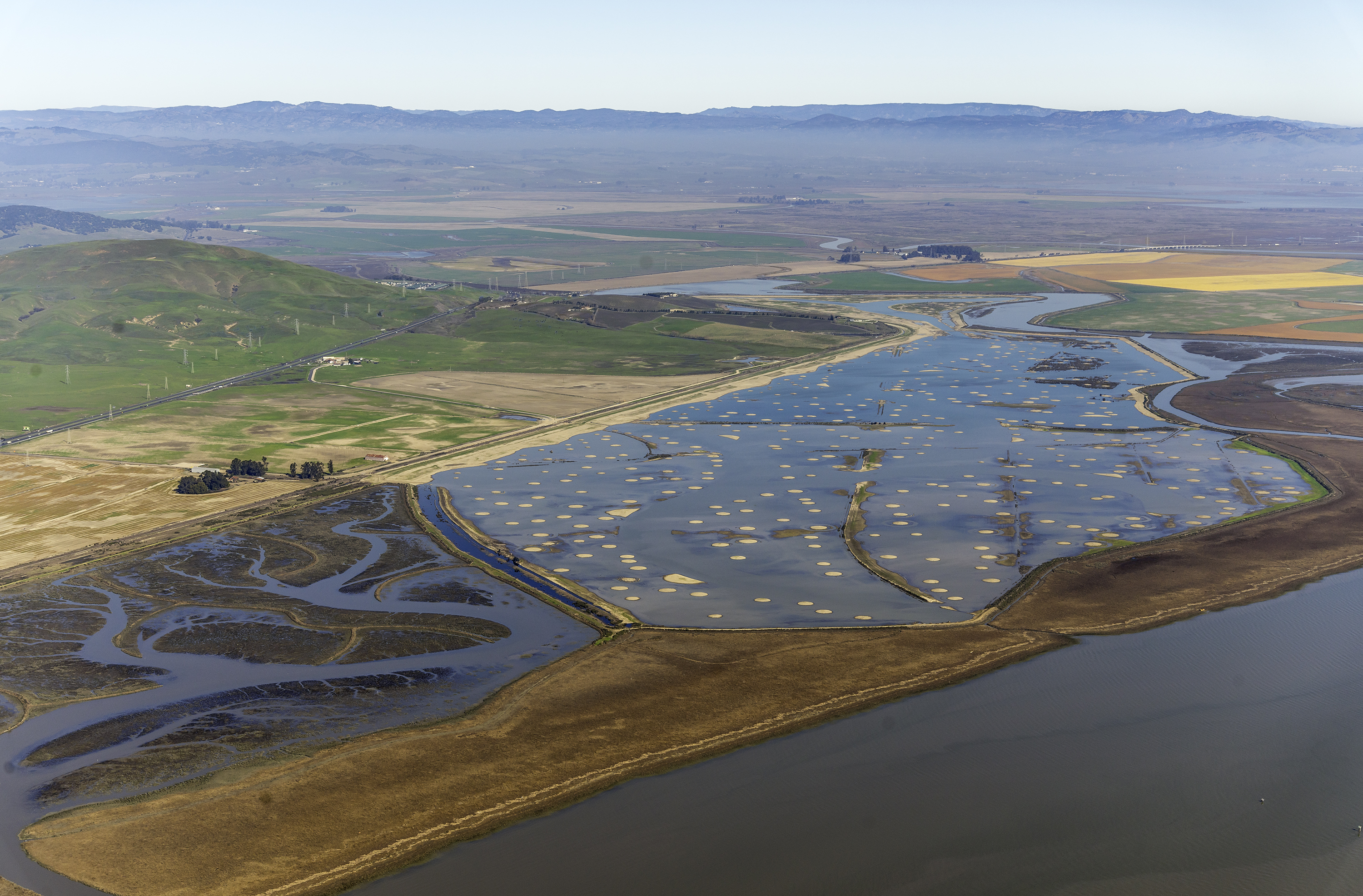
Looking east from the levee-top trail, a silvery swath of bay is dotted with low islands — some tufted with plants, others mere muddy humps that barely break the surface.
This is low tide at the nearly 1,000-acre Sears Point wetland restoration project on the western side of San Pablo Bay. The islands, 500 in all, are actually man-made mounds, scattered across the mudflat as an integral part of the restoration design. Each is roughly 60 feet across and was carefully sculpted so its wide, flat top would submerge at high tide, creating habitat for a specific group of marsh plants. This in turn provides an important suite of ecological functions central to the project’s success.
“Without the mounds, you would just have a big area of open water,” says Julian Meisler, a program manager with Sonoma Land Trust. The organization once owned and now oversees monitoring of the property, which was recently added to the San Pablo Bay National Wildlife Refuge and renamed the Dickson Unit. “We are eagerly watching the success of the vegetation on the mounds.”
A few years ago, that success appeared to be in jeopardy. After the levee separating the restoration site from San Pablo Bay was breached in October 2015, erosion of the mounds was much greater than expected. However, experimental plantings of native Pacific cordgrass were found to stabilize the mounds, according to research conducted by San Francisco State University graduate student Margot Buchbinder in collaboration with staff from the Sonoma Land Trust and the nonprofit Invasive Spartina Project.
“The timeline on these projects is really decades,” says Meisler. “We are looking at 20 years before we have a marsh out there, but the trajectory is good.”
As with many bayside properties throughout the region, a levee kept the restoration site’s soils dry for more than a century. While farmers worked the former marshland, it subsided about six feet – to low for tidal marsh to grow after a simple levee breach. The waters would be too deep, and instead of an intermittently submerged mudflat, there would simply be an extension of San Pablo Bay.
But how could nearly 1,000 acres — more than 700 football fields — be raised by six feet in elevation? The mounds were part of the solution. They would not only provide immediate patches of marsh, but also help dissipate wave and tidal energy and settle sediment already in the Bay waters to the bottom.
Though mounds can be seen as a feature in other restoration projects in the Bay Area, they have previously been installed as high-tide refuges. Sears Point was the first, and is still the only example, where the main purpose was to influence ecosystem-level process such as sedimentation.
Originally the raw earthen mounds, constructed with bulldozers in 2014, were intended to re-vegetate naturally before being exposed to Bay waters, says ecologist Peter Baye, who helped develop the design. The plan called for them to be left in place for up to five years, protected within what would essentially have been a pond formed by the old bayside levee and a new, inland levee constructed at the same time as the mounds. This would have allowed mature root and plant growth to stabilize both the mounds and the new levee before they were connected to the open Bay, and exposed to buffeting by waves and tides.
“The theory was that those first plants would have essentially been sacrificial,” Meisler says. “Once the levee breached, the salt water would kill them — but the roots would hold the mounds in place, and the dead vegetation would act as a comb, pulling sediment out of the water.”
However, that theory was never put to the test. Time limits on funding meant the project needed to be completed sooner, and didn’t allow the years necessary for the mounds to lie fallow, Meisler says. Instead they were largely unvegetated when the levee was cut. In the first year, the mounds lost an average of 1.5 feet in elevation.
While about one-third of that resulted from subsidence of the mounds under their own weight, the loss was still far greater than expected. “The wave erosion of the mounds was extreme after the breach, especially during the spring of 2016,” says Mike Vasey, director of the San Francisco Bay National Estuarine Research Reserve, a partner on the project.
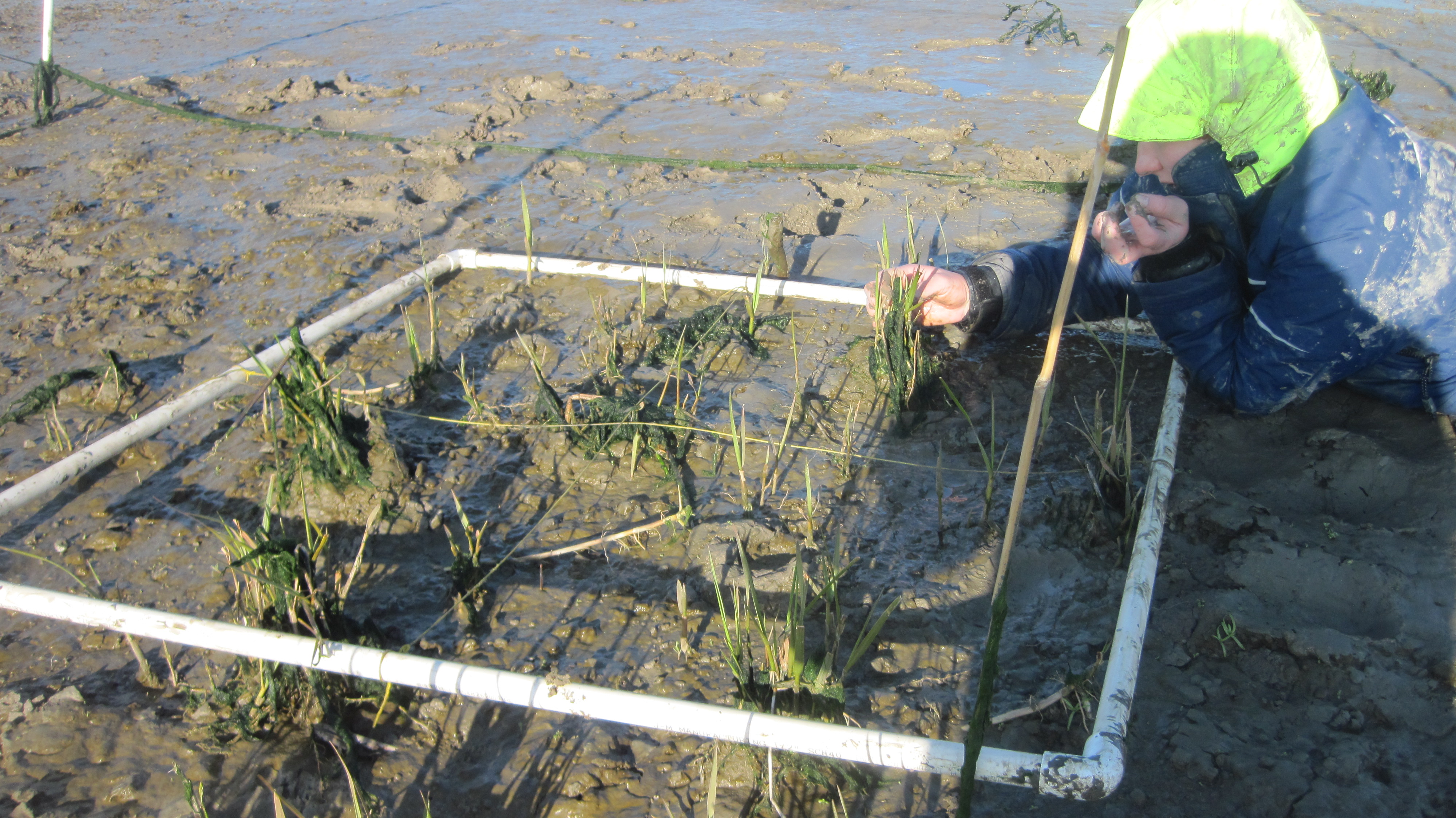
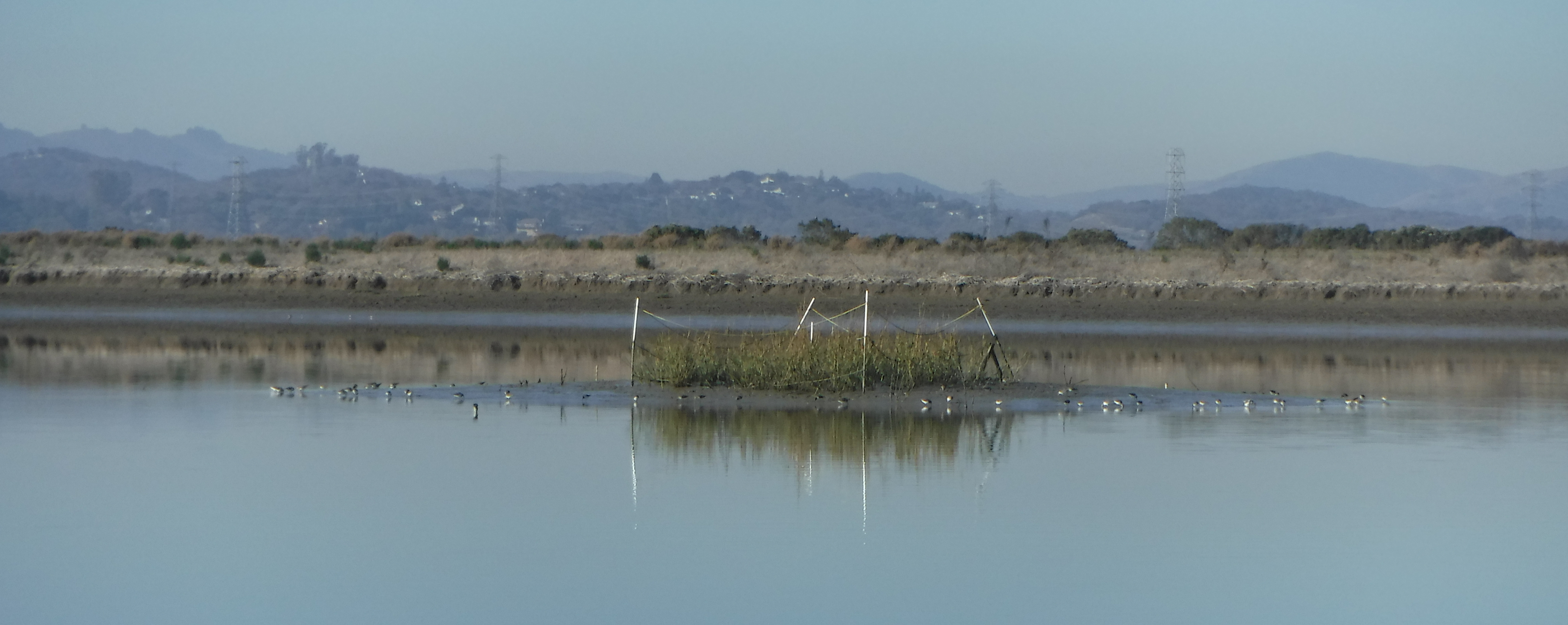
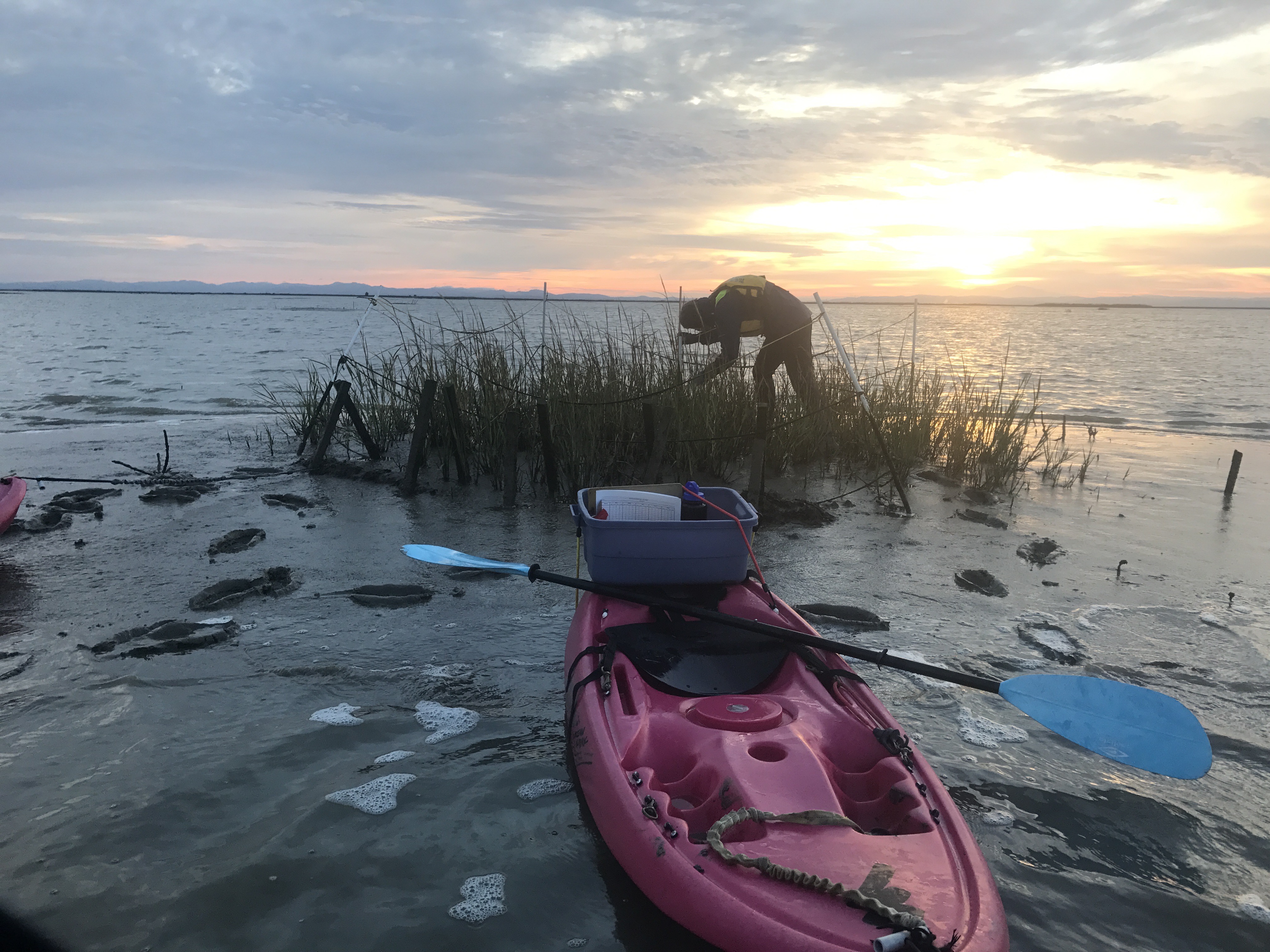
Triage for the mounds began that spring, when Buchbinder installed experimental plots of Pacific cordgrass, Spartina foliosa, which is the only native species suited to the lowest or most inundated marshland. She collaborated with the Invasive Spartina Project to plan and conduct the plantings.
Since Buchbinder’s first round of plantings coincided with the most rapid period of erosion, many plots did not have a chance to take root. But she replanted that fall, and erosion of all the mounds slowed. By 2017, planted mounds — 18 in all — had stopped their rapid erosion. Some have since regained elevation.
“I don’t want to imply that the plants are responsible for stopping all the erosion,” Buchbinder says. “The massive erosion stopped on its own — but [while] the control mounds continued to erode, the Spartina mounds were stabilized.”
And that stabilization means the mounds will stay in place for the future, where they can do the good work of trapping sediment. Already the Bay floor within the Dickson Unit has gained an average of three feet of new mud, according to Vasey.
Yet the new levee still faces challenges. Designed with a gradual bayward slope to provide habitat while protecting the inland highway, railroad, and private properties, it too has been sharply eroded. The Sonoma Land Trust has now turned its attention toward mitigating levee erosion by planting native corgdrass, saltgrass and creeping wild rye. This work is a good example of adaptive management in action, says Baye. “This is happening faster than you can monitor, and they are making science-based pragmatic adjustments in real time, which is difficult.”
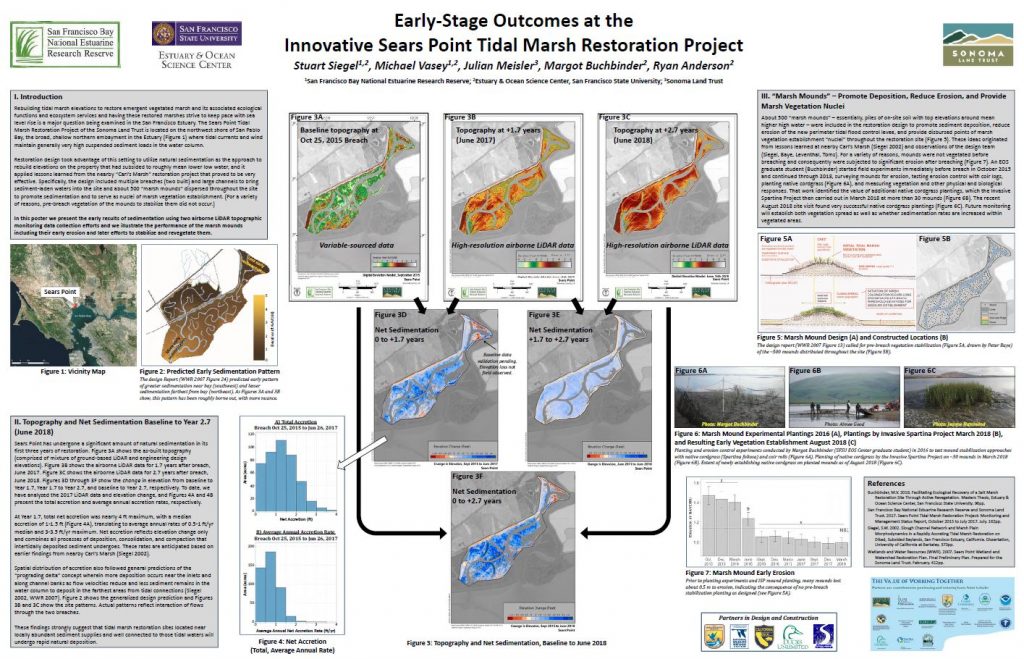
Mound plantings are ongoing, too, since Buchbinder’s initial plantings in 2016 covered only a small fraction of the 500 mounds. This year the Invasive Spartina Project planted another 34 — chosen using high-accuracy LiDAR aerial imagery to identify mounds at the ideal elevation for cordgrass — and Vasey says Sonoma Land Trust partners hope to plant even more in 2019.
At 1,000 acres, the Sears Point restoration project is one of the larger restoration sites in the Bay Area (though it is notably dwarfed by the 15,000-acre South Bay Salt Pond restoration project). Ultimately it represents another step toward the regional goal of securing 100,000 total acres of wetlands, still less than half the historic total of at least 180,000.
As land managers now work to reclaim as much of that lost acreage as possible — to both restore habitat and buffer coastal communities from a rising Bay — it is important that each new project learns from those that have come before it, Meisler says. “All the lessons we have learned on this project need to be put into the design of the next project. What did we learn? What did we do well, what didn’t we do well, and how can we improve?”
Wetland restoration is not only striving to make up lost, soggy, vital, ground; it is also a race against time. “Sea-level rise is progressing at a fairly linear rate now but that all the predictions are that the rate is going to jump sometime before or around midcentury,” Meisler says. “Getting these marshes in place before then is really important.”


 The results are alarming for our state’s future: an estimated four to five feet of sea level rise and loss of one to two-thirds of Southern California beaches by 2100, a 50 percent increase in wildfires over 25,000 acres, stronger and longer heat waves, and infrastructure like airports, wastewater treatment plants, rail and roadways increasingly likely to suffer flooding.