By the time California finally began regulating groundwater use in 2014, most of the San Joaquin Valley was in critical overdraft. The Public Policy Institute of California estimates that groundwater pumping in the region has exceeded replenishment by an average of 1.8 million acre-feet per year over the last few decades. This imbalance was even worse during our last drought, when overuse shot up to 2.4 million acre-feet per year.
Overpumping puts groundwater aquifers at risk of compaction, permanently reducing their water storage capacity and making surface lands sink. Now, however, San Joaquin Valley groundwater managers must find and implement a fix. The state’s Sustainable Groundwater Management Act mandates balancing the region’s pumping with replenishment by 2040.
Managed aquifer recharge — diverting excess flood water so it can soak into the ground — is an obvious remedy. But accelerating recharge in the San Joaquin Valley is easier said than done. “Recharge is slow in silt and clay, and these are ubiquitous across the Central Valley,” explains Graham Fogg, an emeritus hydrogeologist at UC Davis.
Fogg and colleagues have found a new way to speed recharge in the Central Valley: ancient river channels where water can shoot underground. The channels are called paleo valleys because they formed 16,000 years ago, during the last ice age when an expanse of alpine glaciers capped the Sierra Nevada. “As the ice melted, glacial streams were flowing hard year-round,” Fogg says. This rush of water cut deep, wide channels across Central Valley flats on its way the ocean.
As the glaciers melted away, these channels filled up with sediment. “Paleo valleys are 80 to 90 percent sand and gravel that’s extraordinarily coarse,” Fogg says. These ancient channels are also enormous at about a mile across and 100 feet deep. All this makes them ideal for groundwater recharge. He estimates that water soaks into them 60 times faster than into the fine silt and clay that pervade the Central Valley. Using paleo valleys for recharge would also be relatively cheap. “It would be orders of magnitude less expensive than building and maintaining more dams,” Fogg says.
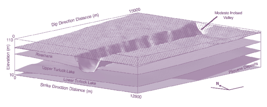
Model of the buried paleo (incised) valley in the Kings River alluvial fan determined with subsurface data from wells (Weissmann 2004). “Modesto, Riverbank, Upper Turlock Lake and Lower Turlock Lake” refer to Pleistocene glacial cycles, with “Modesto” representing the most recent glaciation of the Sierra Nevada that resulted in incision of the ancestral Kings River and backfilling of the paleo valley with very coarse, highly permeable sediments.
So why aren’t we already taking advantage of these marvels of natural infrastructure? We don’t know precisely where the paleo valleys are because the land has changed dramatically. When these channels were first cut, so much of the world’s water was still in glaciers that sea level was about 400 feet lower than it is today. That meant the Sacramento-San Joaquin River Delta was much lower too, so the rivers draining the Sierra Nevada cut far into the land. Over the millennia since then, ice melt refilled the seas and sediment built up the land. Today, California’s paleo valleys are buried.
Some are just a few feet below the surface, though, and these are the channels best suited for recharge. In the early 2000s, Fogg and then-student Gary Weissmann discovered a paleo valley near the surface on the Kings River in Fresno County. “We said, ‘These features have huge potential for recharge — we should find the rest of them,’” Fogg recalls.
It’s been 20 years and little progress has been made since then. This is partly because finding paleo valleys has been difficult. So Fogg and colleagues decided to try a new way of finding these ancient river channels. Late last year, Fogg teamed up with Rosemary Knight, a Stanford geophysicist, and her research group in a pilot study with an underground imaging technique called airborne electromagnetics. Knight has used this technique over the past five years to map inland groundwater basins as well as saltwater intrusion into coastal aquifers.
Airborne electromagnetics entails flying low to the ground in a helicopter towing a transmitter loop about 60 feet across. “An electric current goes through the loop, which sets up a magnetic field that penetrates the ground surface,” Knight explains. This magnetic field generates underground currents that vary with the electrical resistance of the various materials they encounter underground. Resistance is highest in the coarse gravel and sand that fill paleo valleys, and lowest in the fine clay that impedes groundwater recharge. These underground currents then generate their own magnetic fields, which are measured by a receiver mounted on the loop. This gives researchers a picture of what’s underground to a depth of about 1,000 feet.
To see if airborne electromagnetics can spot paleo valleys, the researchers flew a helicopter along the Sierra Nevada foothills in Tulare and Fresno counties. This region includes the paleo valley discovered via borehole data two decades ago, and the big question was whether the team could find it with airborne electromagnetics, too.
The land above this paleo valley doesn’t look special to the naked eye. But airborne electromagnetics confirmed that it’s special underground. “We found the paleo valley — it’s super exciting!” Knight exclaims, leaning forward and smiling with delight. “It’s a massive coarse-grained feature extending out into the valley.” She calls paleo valleys “fastpaths” for delivering Sierra Nevada snowmelt to Central Valley aquifers.
The next step is finding more paleo valleys along the Sierra foothills and Central Valley floor, and Knight is confident that airborne electromagnetics is the way to go. “It’s such a stunning signature,” she says. Fogg agrees, saying the technique is “probably a perfect way to find paleo valleys.”
This pilot project is welcome news for groundwater managers in the San Joaquin Valley. “Everybody knows we have to do more recharge but we don’t know where to do it to maximize rates,” says project collaborator Kassy Chauhan, a civil engineer who leads the North Kings Groundwater Sustainability Agency in Fresno County. “This proves we can figure out where those prime locations are.”
Top photo: A helicopter, towing the airborne electromagnetic system while acquiring data, flies near Pine Flat Dam outside of Fresno, California. Photo: Rebecca Quist
Robin Meadows is an independent science journalist in the San Francisco Bay Area. She’s a water reporter at Maven's Notebook, a California water news site, and contributor to Chemical & Engineering News, Ka Pili Kai, KneeDeep Times, and Scientific American. Robin is also a Pulitzer Center grantee, an Institute for Journalism & Natural Resources fellow, a contributor to The Craft of Science Writing, a mentor with The Open Notebook, and a UC Santa Cruz Science Communication Program graduate. Find her on Tumblr and Twitter.
Our magazine’s media motto for many years has been “Where there’s an estuary, there’s a crowd.” The San Francisco Estuary is a place where people, wildlife, and commerce congregate, and where watersheds, rivers and the ocean meet and mix, creating a place of unusual diversity. In choosing to tell the...
Ever since the state and federal water projects were built in the 1930s and 1940s, California has captured snowmelt in foothill reservoirs, and moved the fresh water from dam releases and river outflows to parched parts of the state via aqueducts hundreds of miles long. A convoluted system of ancient...
Though the Clean Water Act did an amazing job of reducing wastewater and stormwater pollution of the San Francisco Estuary, some contaminants remain thorny problems. Legacy pollutants like mercury washed into the watershed from upstream gold mining, PCBs from old industrial sites, and selenium from agricultural drainage in the San...
Hothouse Earth
By Ariel Rubissow Okamoto
Photo by Megan Nguyen
Nothing could be stranger than sitting in the dark with thousands of suits and heels, watching a parade of promises to decarbonize from companies and countries large and small, reeling from the beauties of big screen rainforests and indigenous necklaces, and getting all choked up.
It was day two of the September 2018 Global Climate Action Summit in San Francisco when I felt it.
At first I wondered if I was simply starstruck. Most of us labor away trying to fix one small corner of the planet or another without seeing the likes of Harrison Ford, Al Gore, Michael Bloomberg, Van Jones, Jerry Brown – or the ministers or mayors of dozens of cities and countries – in person, on stage and at times angry enough to spit. And between these luminaries a steady stream of CEOs, corporate sustainability officers, and pension fund managers promising percentages of renewables and profits in their portfolios dedicated to the climate cause by 2020-2050.
I tried to give every speaker my full attention: the young man of Vuntut Gwichin heritage from the edge of the Yukon’s Arctic National Wildlife Refuge who pleaded with us not to enter his sacred lands with our drills and dependencies; all the women – swathed in bright patterns and head-scarfs – who kept punching their hearts. “My uncle in Uganda would take 129 years to emit the same amount of carbon as an American would in one year,” said Oxfam’s Winnie Byanyima.
“Our janitors are shutting off the lights you leave on,” said Aida Cardenas, speaking about the frontline workers she trains, mostly immigrants, who are excited to be part of climate change solutions in their new country.
The men on the stage, strutting about in feathers and pinstripes, spoke of hopes and dreams, money and power. “The notion that you can either do good or do well is a myth we have to collectively bust,” said New Jersey Governor Phil Murphy whose state is investing heavily in offshore wind farms.
“Climate change isn’t just about risks, it’s about opportunities,” said Blackrock sustainable investment manager Brian Deese.
But it wasn’t all these fine speeches that started the butterflies. Halfway through the second day of testimonials, it was a slight white-haired woman wrapped in an azure pashmina that pricked my tears. One minute she was on the silver screen with Alec Baldwin and the next she taking a seat on stage. She talked about trees. How trees can solve 30% of our carbon reduction problem. How we have to stop whacking them back in the Amazon and start planting them everywhere else. I couldn’t help thinking of Dr. Seuss and his truffala trees. Jane Goodall, over 80, is as fierce as my Lorax. Or my daughter’s Avatar.
Analyzing my take home feeling from the event I realized it wasn’t the usual fear – killer storms, tidal waves, no food for my kids to eat on a half-baked planet – nor a newfound sense of hope – I’ve always thought nature will get along just fine without us. What I felt was relief. People were actually doing something. Doing a lot. And there was so much more we could do.
As we all pumped fists in the dark, as the presentations went on and on and on because so many people and businesses and countries wanted to STEP UP, I realized how swayed I had let myself be by the doomsday news mill.
“We must be like the river, “ said a boy from Bangladesh named Risalat Khan, who had noticed our Sierra watersheds from the plane. “We must cut through the mountain of obstacles. Let’s be the river!”
Or as Harrison Ford less poetically put it: “Let’s turn off our phones and roll up our sleeves and kick this monster’s ass.”
4th California Climate Change Assessment Blues
by Isaac Pearlman
Since California’s last state-led climate change assessment in 2012, the Golden State has experienced a litany of natural disasters. This includes four years of severe drought from 2012 to 2016, an almost non-existent Sierra Nevada snowpack in 2014-2015 costing $2.1 billion in economic losses, widespread Bay Area flooding from winter 2017 storms, and extremely large and damaging wildfires culminating with this year’s Mendocino Complex fire achieving the dubious distinction of the largest in state history. California’s most recent climate assessment, released August 27th, predicts that for the state and the Bay Area, we can expect even more in the future.
The California state government first began assessing climate impacts formally in 2006, due to an executive order by Governor Schwarzenegger. California’s latest iteration and its fourth overall, includes a dizzying array of 44 technical reports; three topical studies on climate justice, tribal and indigenous communities, and the coast and ocean; as well as nine region-specific analyses.
The results are alarming for our state’s future: an estimated four to five feet of sea level rise and loss of one to two-thirds of Southern California beaches by 2100, a 50 percent increase in wildfires over 25,000 acres, stronger and longer heat waves, and infrastructure like airports, wastewater treatment plants, rail and roadways increasingly likely to suffer flooding.
For the first time, California’s latest assessment dives into climate consequences on a regional level. Academics representing nine California regions spearheaded research and summarized the best available science on the variable heat, rain, flooding and extreme event consequences for their areas. For example, the highest local rate of sea level rise in the state is at the rapidly subsiding Humboldt Bay. In San Diego county, the most biodiverse in all of California, preserving its many fragile and endangered species is an urgent priority. Francesca Hopkins from UC Riverside found that the highest rate of childhood asthma in the state isn’t an urban smog-filled city but in the Imperial Valley, where toxic dust from Salton Sea disaster chokes communities – and will only become worse as higher temperatures and less water due to climate change dry and brittle the area.
According to the Bay Area Regional Report, since 1950 the Bay Area has already increased in temperature by 1.7 degrees Fahrenheit and local sea level is eight inches higher than it was one hundred years ago. Future climate will render the Bay Area less suitable for our evergreen redwood and fir forests, and more favorable for tolerant chaparral shrub land. The region’s seven million people and $750 billion economy (almost one-third of California’s total) is predicted to be increasingly beset by more “boom and bust” irregular wet and very dry years, punctuated by increasingly intense and damaging storms.
Unsurprisingly, according to the report the Bay Area’s intensifying housing and equity problems have a multiplier affect with climate change. As Bay Area housing spreads further north, south, and inland the result is higher transportation and energy needs for those with the fewest resources available to afford them; and acute disparity in climate vulnerability across Bay Area communities and populations.
“All Californians will likely endure more illness and be at greater risk of early death because of climate change,” bluntly states the statewide summary brochure for California’s climate assessment. “[However] vulnerable populations that already experience the greatest adverse health impacts will be disproportionately affected.”
“We’re much better at being reactive to a disaster than planning ahead,” said UC Berkeley professor and contributing author David Ackerly at a California Adaptation Forum panel in Sacramento on August 27th. “And it is vulnerable communities that suffer from those disasters. How much human suffering has to happen before it triggers the next round of activity?”
The assessment’s data is publicly available online at “Cal-adapt,” where Californians can explore projected impacts for their neighborhoods, towns, and regions.


 The results are alarming for our state’s future: an estimated four to five feet of sea level rise and loss of one to two-thirds of Southern California beaches by 2100, a 50 percent increase in wildfires over 25,000 acres, stronger and longer heat waves, and infrastructure like airports, wastewater treatment plants, rail and roadways increasingly likely to suffer flooding.