![]()
Download: Estuary News, February 2013 PDF
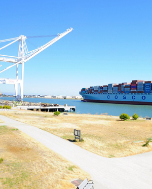
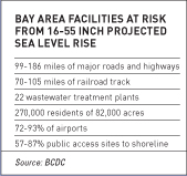
California has emerged as a national leader in climate change mitigation through aggressive laws aimed at reducing carbon emissions. But adaptation, which involves responding to the impacts of climate change such as sea-level rise and severe weather, is unwieldy at the state level. That’s particularly true in the San Francisco Bay Area, where a dense population, waterfront location, and diverse range of cities, counties, and agencies make adaptation planning incredibly complex. Yet it’s critical that we get it right, with so much coastal infrastructure threatened by flooding, storm surges, and sea-level rise, including many of the region’s bridges, highways, airports, railways, wastewater treatment plants, seaports, and energy facilities and pipelines.
Until recently, the bulk of climate-change adaptation in the Bay Area has been piecemeal and largely conceptual. Local government autonomy continues to challenge attempts at regional coordination. But three projects are now taking exploratory steps toward a region-wide climate-change adaptation strategy, and may soon join forces.
 The first, launched in July 2012, is called the Bay Area Climate & Energy Resilience Project. The project is led by the interagency Joint Policy Committee (JPC), which includes the big four in regional planning for land use (Association of Bay Area Governments), transportation (Metropolitan Transportation Commission), air quality (Bay Area Air Quality Management District) and the Bay (SF Bay Conservation & Development Commission, or BCDC). The aim of the Resilience Project is to assess the adaptation needs of diverse stakeholders in all nine Bay Area counties, including cities, special districts, and NGOs, says JPC climate strategist Bruce Riordan. “We’re talking to the folks who are doing the work — or should be,” he says. “From that we’re devising a proposal on how to structure adaptation for the region.” That includes responding not only to adverse effects like sea-level rise, but also to heat waves, water and energy shortages, and health and economic impacts. An action plan should be complete by March 2013.
The second project focuses more narrowly on sea level rise impacts on coastal areas. Adapting to Rising Tides (ART) is a partnership between BCDC and the National Oceanic and Atmospheric Administration. The ART project kicked off in 2010 with two questions in mind: How will sea-level rise and storms affect the Bay Area, and what strategies (ranging from collaborative planning by public and private interests to physical changes such as seawalls or relocation) will allow us to reduce and manage this risk? To begin to get a grip on these complex issues, the project opened with a pilot program assessing the vulnerability and adaptive opportunities of the East Bay shoreline between Emeryville and Union City. This 23-mile stretch contains significant at-risk infrastructure, including the Oakland Airport, the Port of Oakland, extensive ground transportation, and 30 different wastewater facilities. Once the pilot project is completed, ART will expand into other stretches of the bayshore, and eventually to a region-wide perspective. “Part of the reason to look at the problem at a variety of scales is to remind people that it needs to be solved at a variety of scales,” says BCDC senior planner Lindy Lowe. “The only way we’re really going to be able to confront this as a region is to involve all levels of governance.”
 The largest, longest-term project of the three, into which the others could be folded, is also the youngest. After lengthy and contentious discussion, the JPC voted unanimously last September to take responsibility for developing a Regional Sea Level Rise Adaptation Strategy. According to outgoing JPC senior advisor Will Travis, the committee will coordinate the effort, driven by BCDC and ABAG staff. It could take ten years and $20 million to hash out a plan, he says, and likely billions of dollars and decades more to implement it. That’s daunting, but the consequences of inaction will be worse. “If you have flooding that affects the transportation infrastructure, it doesn’t matter if your house is high and dry,” Travis says. “It would really bring the region to its knees.” For the time being, it’s unclear where all that money will come from; only the first phase of the planning process, which involves supporting the expansion of the ART project to other parts of the region, has been funded to date. “We’re at the very beginning of a very long race,” Travis says.
MORE INFO?
ART Project:
Bay Commission Policies
Photo courtesy Port of Oakland.
CONTACT: Bruce Riordan, [email protected], Lindy Lowe, [email protected], Will Travis, [email protected]
By Ariel Rubissow Okamoto

Nothing could be stranger than sitting in the dark with thousands of suits and heels, watching a parade of promises to decarbonize from companies and countries large and small, reeling from the beauties of big screen rainforests and indigenous necklaces, and getting all choked up.
It was day two of the September 2018 Global Climate Action Summit in San Francisco when I felt it.
At first I wondered if I was simply starstruck. Most of us labor away trying to fix one small corner of the planet or another without seeing the likes of Harrison Ford, Al Gore, Michael Bloomberg, Van Jones, Jerry Brown – or the ministers or mayors of dozens of cities and countries – in person, on stage and at times angry enough to spit. And between these luminaries a steady stream of CEOs, corporate sustainability officers, and pension fund managers promising percentages of renewables and profits in their portfolios dedicated to the climate cause by 2020-2050.
I tried to give every speaker my full attention: the young man of Vuntut Gwichin heritage from the edge of the Yukon’s Arctic National Wildlife Refuge who pleaded with us not to enter his sacred lands with our drills and dependencies; all the women – swathed in bright patterns and head-scarfs – who kept punching their hearts. “My uncle in Uganda would take 129 years to emit the same amount of carbon as an American would in one year,” said Oxfam’s Winnie Byanyima.
“Our janitors are shutting off the lights you leave on,” said Aida Cardenas, speaking about the frontline workers she trains, mostly immigrants, who are excited to be part of climate change solutions in their new country.
The men on the stage, strutting about in feathers and pinstripes, spoke of hopes and dreams, money and power. “The notion that you can either do good or do well is a myth we have to collectively bust,” said New Jersey Governor Phil Murphy whose state is investing heavily in offshore wind farms.
“Climate change isn’t just about risks, it’s about opportunities,” said Blackrock sustainable investment manager Brian Deese.
But it wasn’t all these fine speeches that started the butterflies. Halfway through the second day of testimonials, it was a slight white-haired woman wrapped in an azure pashmina that pricked my tears. One minute she was on the silver screen with Alec Baldwin and the next she taking a seat on stage. She talked about trees. How trees can solve 30% of our carbon reduction problem. How we have to stop whacking them back in the Amazon and start planting them everywhere else. I couldn’t help thinking of Dr. Seuss and his truffala trees. Jane Goodall, over 80, is as fierce as my Lorax. Or my daughter’s Avatar.
Analyzing my take home feeling from the event I realized it wasn’t the usual fear – killer storms, tidal waves, no food for my kids to eat on a half-baked planet – nor a newfound sense of hope – I’ve always thought nature will get along just fine without us. What I felt was relief. People were actually doing something. Doing a lot. And there was so much more we could do.
As we all pumped fists in the dark, as the presentations went on and on and on because so many people and businesses and countries wanted to STEP UP, I realized how swayed I had let myself be by the doomsday news mill.
“We must be like the river, “ said a boy from Bangladesh named Risalat Khan, who had noticed our Sierra watersheds from the plane. “We must cut through the mountain of obstacles. Let’s be the river!”
Or as Harrison Ford less poetically put it: “Let’s turn off our phones and roll up our sleeves and kick this monster’s ass.”
by Isaac Pearlman
Since California’s last state-led climate change assessment in 2012, the Golden State has experienced a litany of natural disasters. This includes four years of severe drought from 2012 to 2016, an almost non-existent Sierra Nevada snowpack in 2014-2015 costing $2.1 billion in economic losses, widespread Bay Area flooding from winter 2017 storms, and extremely large and damaging wildfires culminating with this year’s Mendocino Complex fire achieving the dubious distinction of the largest in state history. California’s most recent climate assessment, released August 27th, predicts that for the state and the Bay Area, we can expect even more in the future.
The California state government first began assessing climate impacts formally in 2006, due to an executive order by Governor Schwarzenegger. California’s latest iteration and its fourth overall, includes a dizzying array of 44 technical reports; three topical studies on climate justice, tribal and indigenous communities, and the coast and ocean; as well as nine region-specific analyses.
 The results are alarming for our state’s future: an estimated four to five feet of sea level rise and loss of one to two-thirds of Southern California beaches by 2100, a 50 percent increase in wildfires over 25,000 acres, stronger and longer heat waves, and infrastructure like airports, wastewater treatment plants, rail and roadways increasingly likely to suffer flooding.
For the first time, California’s latest assessment dives into climate consequences on a regional level. Academics representing nine California regions spearheaded research and summarized the best available science on the variable heat, rain, flooding and extreme event consequences for their areas. For example, the highest local rate of sea level rise in the state is at the rapidly subsiding Humboldt Bay. In San Diego county, the most biodiverse in all of California, preserving its many fragile and endangered species is an urgent priority. Francesca Hopkins from UC Riverside found that the highest rate of childhood asthma in the state isn’t an urban smog-filled city but in the Imperial Valley, where toxic dust from Salton Sea disaster chokes communities – and will only become worse as higher temperatures and less water due to climate change dry and brittle the area.
According to the Bay Area Regional Report, since 1950 the Bay Area has already increased in temperature by 1.7 degrees Fahrenheit and local sea level is eight inches higher than it was one hundred years ago. Future climate will render the Bay Area less suitable for our evergreen redwood and fir forests, and more favorable for tolerant chaparral shrub land. The region’s seven million people and $750 billion economy (almost one-third of California’s total) is predicted to be increasingly beset by more “boom and bust” irregular wet and very dry years, punctuated by increasingly intense and damaging storms.
Unsurprisingly, according to the report the Bay Area’s intensifying housing and equity problems have a multiplier affect with climate change. As Bay Area housing spreads further north, south, and inland the result is higher transportation and energy needs for those with the fewest resources available to afford them; and acute disparity in climate vulnerability across Bay Area communities and populations.
“All Californians will likely endure more illness and be at greater risk of early death because of climate change,” bluntly states the statewide summary brochure for California’s climate assessment. “[However] vulnerable populations that already experience the greatest adverse health impacts will be disproportionately affected.”
“We’re much better at being reactive to a disaster than planning ahead,” said UC Berkeley professor and contributing author David Ackerly at a California Adaptation Forum panel in Sacramento on August 27th. “And it is vulnerable communities that suffer from those disasters. How much human suffering has to happen before it triggers the next round of activity?”
The assessment’s data is publicly available online at “Cal-adapt,” where Californians can explore projected impacts for their neighborhoods, towns, and regions.