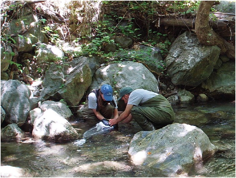
Sampling insects in stream. Photo: David Rundio, NOAA
Mercury in Trout Diet
The steelhead of Big Sur seemingly live in fish paradise. The water is cold and clean, the creeks are alive with insect larvae, and migrating to the Pacific involves an easy swim from spawning grounds shaded by redwood forest. A new study, however, finds that fish in this pristine habitat are laden with an insidious toxin—mercury.
While studying steelhead at the University of California’s Landels-Hill Big Creek Reserve, a protected canyon habitat in Big Sur, Dave Rundio of NOAA’s Southwest Fisheries Science Center found that terrestrial insects that fell into the creek comprise about half of the diet of larger, older fish. This reliance on land-based foods made Rundio wonder just how unsullied these trout were. He recalled UC Santa Cruz atmospheric scientist Peter Weiss-Penzias had found that fog can deliver mercury upwelled by the ocean to shoreside food webs, as reported in Estuary News, March 2015. The two scientists teamed up to analyze mercury levels in the invertebrates commonly eaten by steelhead at Big Creek, as well as the fish themselves.
“The values that we’re finding in Big Creek trout are higher than values reported in fish from most other streams and rivers across the West Coast,” Rundio says. The older and larger the fish, the higher the body burden of mercury they tended to carry. The stream insects that younger fish relied on were relatively mercury free. Not so for land-based insects. Among the worst offenders were terrestrial isopods. Also known as roly polies, these non-native invertebrates eat only leaf detritus and were the most abundant terrestrial prey in older fish. The fact that animals so low on the food chain are accumulating mercury suggests the toxin is being deposited by the area’s heavy coastal fog.
“Mercury has a way of slithering its way into surprising locations,” Weiss-Penzias says. “The West Coast is particularly vulnerable to additional mercury deposition.”
Is eating terrestrial food worth the risk for trout? The mercury levels delivered by invertebrates falling into the creek aren’t high enough to kill the fish. And terrestrial prey are an important source of calories, especially in spring, when aquatic prey are scarce after winter storms and floods. However, studies in other fish indicate the pollutant could be causing changes in gene and hormone expression, behavior, growth, or reproductive success.
The discovery of so much mercury in fish is a reminder that when it comes to airborne pollutants, “there is no ‘away,’” says Weiss-Penzias.
“We often think of the ocean as one habitat, and a stream and its forests as another, separate ecosystem,” Rundio says. “But in reality, they’re all connected.” KATHLEEN M. WONG
In 2019, the California State Lands Commission compiled a report studying a chronic derelict vessel issue in the five-county region that makes up the Sacramento-San Joaquin Delta. These abandoned ships come in all shapes and sizes. They range from weekend party platforms, to 100-foot steel-hulled tugboats. The left-for-dead boats present a number of issues ranging from releasing environmental toxins and presenting navigational nightmares, to acting as points of refuge for people looking to get off the map (see prior stories in Estuary News April and June 2012).
Dealing with the headache of abandoned ships in the Delta and the San Francisco Bay is nothing new. Harbor masters and local marine law enforcement have been making visits to illegal and unregistered liveaboards for decades. According to the State Lands Commission report, in 2018 there were 670,000 registered vessels in California. But there were another 470,000 that had expired registration, which marks them as potential candidates for abandonment. Using an aerial survey, the report documented 250 recreational vessels and 55 commercial sized abandoned vessels—the worst offenders in terms of toxins and navigational blockages—in the five-county region of the Delta.
Historically, one of the challenges of dealing with abandoned vessels is that they are found in areas that are jurisdictionally-ambiguous. And, even if the responsibility is clear, the next issue has always been how to pay for the removal and demolition of the vessel, which in the case of large commercial vessels require close to half-a-million dollars per boat when the cost of the associated spill remediation or site cleanup are factored in.
The intent of the State Lands Commission Report wasn’t just to point out a problem lurking in plain sight. Instead, the report created a framework on how to tackle the issue. “We hoped the report would be a springboard for funding and resources, and then Covid happened,” says Sheri Pemberton, chief of external affairs for the State Lands Commission. “So in the context of a lot of competing interests, our hope is that we can continue to have conversations with stakeholders, but the budget outlook continues to be bleak.” DANIEL MCGLYNN
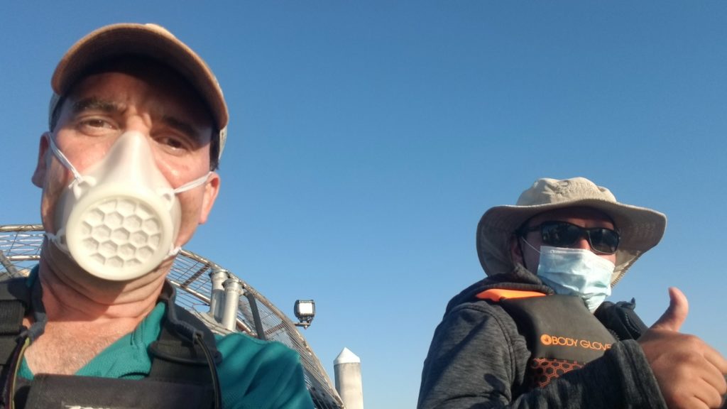
Face mask made for the Invasive Spartina Project on a 3D printer. Photo: ISP
Sticking to it With Spartina
Despite a year full of hurdles, the groundbreaking Invasive Spartina Project (ISP) has managed to move forward on track, says Marilyn Latta of the Coastal Conservancy.
“It has been incredibly challenging,” says Latta, who manages the project. “This is a team of people who are incredibly committed to finishing the work, and they push themselves really hard.”
For nearly two decades, the ISP has been working to eradicate invasive species of spartina within the San Francisco Bay’s marshlands, reported in depth in Estuary News in September 2019. Even in an ordinary year, the project requires interfacing with a multidisciplinary team of environmental planners, restoration construction experts, and over 150 landowners to tackle over 70,000 acres of marsh lands—no small task.
This year, the team had to quickly develop robust Covid-19 safety protocols—and adapt to weeks of working in choking wildfire smoke, amid a late-summer heat wave. But the team carried on—some in special face masks designed and 3D-printed specifically for their use, to offer more comfort under strenuous conditions. Treatment Manager Drew Kerr says, “I used it every single field day this season and still really like it. Great air flow and a high level of protection with that disposable 99% filter.”
When treatment began in 2005, there were about 800 acres of invasive spartina dotted across 70,000 acres of marsh. This year, the team found a total of only 33.4 acres (down from 36.9 acres in 2019)—most of which are located in areas where treatment has been restricted due to federal protection of the endangered California Ridgway’s rail.
2020 project highlights include herbicide treatment of a new area—Citation Marsh in San Leandro—which holds one of the Bay’s largest current infestations. The greatest progress was made in the Hayward Region (the invasive coverage reduced by more than three acres) and Dumbarton South Region (about half an acre). Additionally, the project was awarded a $4 million Restoration Authority grant, under the umbrella of the California Invasive Plant Council. JACOBA CHARLES
In 2016 the City of San Jose became the first Bay Area municipality to get credit for homeless encampment cleanups under its stormwater permit (see prior story Estuary News December 2016). So far, the city has exceeded the permit’s annual requirements, most recently removing 446 tons of rubbish—more than double its goal—from encampments along waterways. But Covid-19 has complicated this effort. To help contain the pandemic, the Centers for Disease Control and Prevention stipulates against dispersing the homeless.
“Shelter in place includes people who are unsheltered too,” says Jeff Scott, a spokesperson for the City of San Jose’s Housing Department. The city stopped dismantling encampments in March and, not surprisingly, they have since mushroomed along creeks as well as in parks and wooded areas. “There are many dozens of encampments,” he says. Now that abatement is no longer an option, San Jose is taking a new tack to controlling the trash that homeless people generate near creeks and on public lands.
The city provides garbage service in the form of bags and dumpsters at large encampments, which can include dozens of people. This approach had previously been adopted by nonprofits, including Downtown Streets Team in Oakland as well as the Clean River Alliance in the Russian River watershed (see Helping the Homeless Clean Up Watersheds, Estuary News, 2019). In addition, San Jose has gotten more than 3,000 people—about half of the unsheltered population in the 2019 homeless census—off the streets and into temporary emergency shelters and motel rooms. “It feels good to do some good for people,” Scott says. He’s uncertain whether these new services will continue post-pandemic, though, because they are funded partly by the Coronavirus Aid, Relief, and Economic Security (CARES) Act.
Deb Kramer, who directs the nonprofit Keep Coyote Creek Beautiful, is saddened by the proliferation of encampments that pollute the creek she loves, which runs right through the heart of San Jose. But she also has reason for optimism. Her group follows county safety protocols such as social distancing, and recent Coyote Creek cleanups have drawn as many as 50 volunteers. “People are signing up in groups and they’re excited to see each other,” she says. “This is an opportunity to get outdoors and also feel good about cleaning up the environment—every little bit counts.” ROBIN MEADOWS
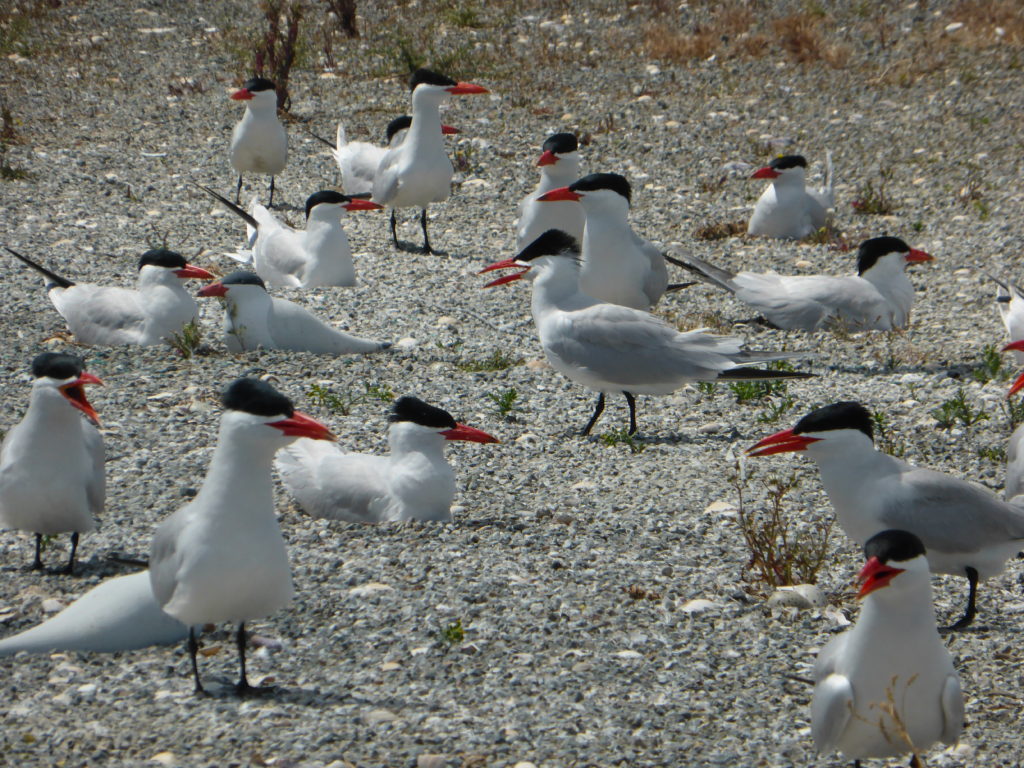
As Caspian terns migrated north on the Pacific Flyway in 2015, they looked down on San Francisco Bay and spotted a colony of their brethren. They didn’t know, however, that the terns in the Don Edwards San Francisco National Wildlife Refuge were actually 500 decoys, and that the familiar cacophony was being piped through MP3 players.
Estuary News wrote about the effort to attract terns to the San Francisco Bay in June 2017. To reduce the Caspian tern population on East Sand Island in the Columbia River Estuary where the terns were feasting on endangered salmonids, the US Army Corps of Engineers developed a plan to reduce habitat in that estuary and create nesting habitat within the terns’ breeding range, including at Don Edwards.
On five modified islands in ponds A16 and SF2, the artificial social attraction succeeded in establishing nesting colonies. In 2015, the first year of the project, USGS biologists counted 224 pairs of breeding birds with 174 fledgling chicks. In 2016, they counted 317 breeding pairs. The final USGS report stated that terns made 664 nests and fledged at least 239 chicks in 2017, the final year of the project.
“Caspian terns nested when social attraction was in use and have continued nesting without its use in the years following,” says USFWS wildlife biologist Rachel Tertes. In a May 2019 survey, USGS counted 139 Caspian terns at Pond A16 and 241 at SF2, says biologist Alex Hartman. Due to pandemic restrictions, the counts in 2020 were based on a one-day observation. Tertes observed at least 297 Caspian tern adults and 30 chicks at SF2, and at least 200 adults at A16.
The effort to reduce habitat on East Sand Island in Oregon was perhaps too successful. The colony was not monitored in 2020, says Daniel Roby, a retired Department of Fisheries and Wildlife professor at Oregon State University, but he heard the colony was much smaller and failed to produce any young Caspian terns. “Now my concern is more for the future of the East Sand Island tern colony, because it was formerly the largest and most productive breeding colony for the species in the Pacific Flyway,” Roby says. ALETA GEORGE
While the rest of the world was cutting back on their commute, practicing social distancing, and sheltering at home, the birds that use Alcatraz Island as an annual nesting site thrived. This drastic decline in tourists and boat activity allowed one bird in particular, the Brandt’s Cormorant, to show up in record numbers. According to the National Park Service, who oversees the bird monitoring on the island, 2,648 pairs — the highest number ever recorded — were seen nesting on the island from March through August while it was closed to the public. Biologists also observed that the Brandt’s Cormorant expanded their nesting area into newly deserted parts of the island.
About 15% of the island is typically off-limits to foot traffic and available for migratory birds to nest, says Lidia D’Amico, a biologist on Alcatraz Island. But this year, amidst closures due to the Covid-19 pandemic, wildlife had free reign on the island. (Islands make good refuge for other Bay critters such as harbor seals, as reported in Estuary News in December 2018).
The Brandt’s Cormorant, a sleek water bird with a distinct bright blue throat pouch, has nested on Alcatraz Island since the early 1990s. It’s the only nesting site for this species in the Bay, and although their populations are stable, these birds are protected under the Migratory Bird Treaty Act. The abandoned structures found on the northwest corner of the island provide an unlikely yet alluring habitat for these ground-nesting birds. Because of the dangers associated with building and maintaining a nest on the ground, they’re known to be extremely sensitive to disturbances and often flee the coop at the first sign of intrusion.
Tours of the island grounds are operating at a lower capacity and a return to normal numbers for this popular tourist destination seems inevitable. However, this spike in nesting numbers for the Brandt’s Cormorant, D’Amico says, provides a strong baseline for how birds respond and behave to disturbances … or in the case of the current pandemic, lack thereof. ASHLEIGH PAPP
In the continuing legal combat over Point Buckler island (see Estuary News June 2016, and February and March 2018), Chief Judge Kimberly Mueller of the US District Court for the Eastern District of California ruled in September that owner John Sweeney and co-defendant Point Buckler Club, LLC violated the federal Clean Water Act (CWA) by excavating and dumping thousands of cubic yards of soil into the 39-acre island’s tidal channels and marsh without a permit in the process of converting a disused duck hunting club at the edge of Suisun Bay into a kite-sailing resort. The US Department of Justice acted for the US Environmental Protection Agency in bringing the case against Sweeney.
Judge Mueller, an Obama appointee, considered testimony by wetlands restoration expert Stuart Siegel, wetlands ecologist Peter Baye, and fish biologist Bruce Herbold, among others. She held that Point Buckler island “has ceased functioning as a tidal marsh ecosystem” after Sweeney’s actions. In finding that Sweeney had discharged pollutants in the form of fill into waters of the United States, the judge rejected arguments that the discharges were exempt from the CWA, that the prosecution violated the Takings Clause of the Fifth Amendment and was vindictive, and that terms such as “wetlands” were unconstitutionally vague.
Judge Mueller will issue a separate opinion on the penalty for Sweeney’s violations of the CWA, including restoration of the island’s wetlands. A hearing on this phase was held in October. Sweeney’s attorney had previously contended that his client couldn’t afford to pay for the restoration and didn’t have the necessary equipment.
Meanwhile, on a parallel track, the San Francisco Bay Regional Water Quality Control Board and the Bay Conservation and Development Commission continue their appeal of a 2017 Solano County Superior Court decision voiding the $3.6 million in fines and the restoration requirements that the two agencies imposed on Sweeney. “Our focus is to understand how the beneficial uses of the site can be restored,” says Keith Lichten, chief of the Regional Board’s Watershed Management Division.
The state Attorney General’s office recently submitted a supplemental brief arguing that the federal court ruling that Sweeney violated the CWA means that the portion of the Superior Court decision addressing the Board’s administrative civil liability order based on the CWA was in error and should be reversed, as, by extension, should the other portion affecting the cleanup and abatement order based on the Porter-Cologne Act, the state’s equivalent of the CWA. No date has been set for the appeal hearing.
Although not a party to either suit, San Francisco Baykeeper has been following the cases. Staff Attorney Nicole Sasaki welcomed Judge Mueller’s decision: “The violations on Point Buckler Island were both brazen and unapologetic, and inflicted severe damage on 30 acres of wetland.” She also commented on the role of the federal agencies: “It is heartening that EPA and DOJ diligently prosecuted the case, and there was no sign of undue political interference. This is remarkable, because under the Trump administration the agencies have played fast and loose with the Clean Water Act. The EPA recently made the bizarre argument on behalf of Cargill’s desire to develop its South Bay salt ponds that the ponds are not water, and therefore not under the jurisdiction of the CWA.” A federal judge ruled otherwise.
Sasaki hopes for favorable outcomes in the state cases: “State agencies already struggle to prioritize enforcement, and this struggle will only get worse due to staffing cuts during the pandemic. We need our agencies to enforce the law to protect our limited natural resources. We don’t need another obstacle to enforcement.” JOE EATON
Dealing with climate change around the Bay is not just a matter of planning. To confront so huge a challenge in a democracy, a lot of learning must go on, on everyone’s part. The public has to get used to new and upsetting facts of life; politicos and other authorities have to gauge what their constituents will accept at a given moment. Planners around the ay are moving with caution. They lay out some options, propose some baby steps, sound out opinion, promise better information, and in general prepare the ground for more difficult decisions to come.
This is surely the case in the Marin town of Corte Madera, which is nearing the end of a two-year process to develop its first Climate Adaptation Plan.
Like Caesar’s Gaul, Corte Madera has three parts, each with its character and risks. In extensive hilly neighborhoods, the big concern is fire safety. In the central area of the city, rising groundwater and stormwater flooding are the focus. Then there’s the bayshore itself, where houses and shopping areas on low-lying former marshland—together with extensive marshes that remain—are at risk from the definitive challenge, sea level rise.
This Bay zone has three components. The precious band of intact and restored marshes is beginning to erode. Behind it a large levee protects, among other things, a railroad right of way and the shopping center that generates much of the town’s enviable wealth. A preliminary estimate places the cost of raising and improving this barrier at $14 million, with the option of buttressing it further later. Improvements would include “nature-based” options to buffer the rising tides.
Matters are trickier in the third region, in the elbow where the Tiburon peninsula begins. Here, two neighborhoods built on fill in the last century, and protected by poor levees, are already under stress. The price tag to protect them until 2050 looks like $44 million, including an expensive and habitat-impairing tidal gate on San Clemente Creek.
The Climate Adaptation Plan groups measures under the headings Protect, Accommodate, and Retreat. Some preliminary polling showed little public appetite for the latter. “Should we defend everything?” asked town public works director R. J. Suokko at a Zoom meeting on November 19. “Yes, you say. It’s almost unanimous.”
Reading the emerging plan closely, though, a ghostly handwriting glimmers on the wall. After listing many caveats, the text continues, “It is still essential to begin the difficult conversation with Corte Maderans.”
One step offered is to mandate disclosure of the risk when property changes hands. Another is to place a Floodplain Frontline Zone on the most threatened areas, discouraging further improvements. A Floodplain Accommodation Zone at slightly higher elevation would allow building with safeguards. A “regional managed retreat advisory board” is proposed; this idea got support in one of several online straw votes conducted in the course of the evening. A participant asked, “Does managed retreat mean local migration?” Hearing a “yes,” he continued: “Did people understand this when they voted just now?”
Gently, gently. This process will take time. JOHN HART
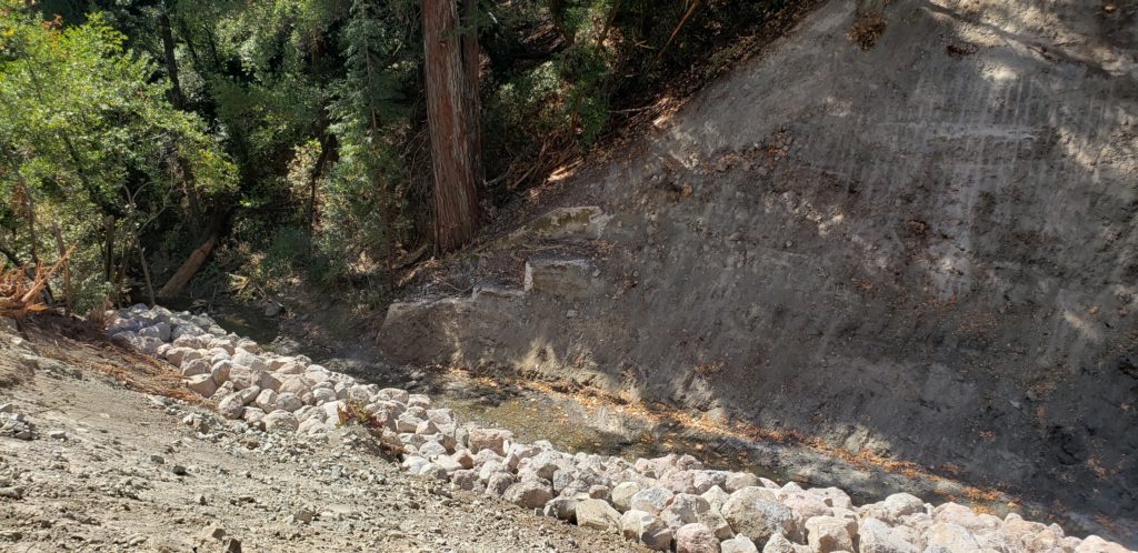
Recent removal of York Dam, Napa County, pre-fire Fall 2020. Photo: Amber Manfree.
Closure on Klamath Dams
After plans to remove four dams on the Klamath River seemed in danger of stalling out this summer, with owner PacifiCorps balking at potential cost overruns, California Governor Gavin Newsom and Oregon Governor Kate Brown stepped in to assure the Warren Buffett-owned company that the two states will pick up unexpected costs and serve as co-licensees of the project. Removing the four dams—at an estimated cost of up to $500 million—will free up cold water for salmon and miles of spawning habitat that has been inaccessible to the fish for close to a century. The Karuk and Yurok tribes, which rely on the fish for food and spiritual sustenance, are excited to see the project move forward again. “It is our sacred duty to bring balance to the Klamath River,” said Joseph James, Chairman of the Yurok Tribe. “The Yurok Tribe will never rest until the dams are out and the river is healed.” LISA OWENS VIANI
Our magazine’s media motto for many years has been “Where there’s an estuary, there’s a crowd.” The San Francisco Estuary is a place where people, wildlife, and commerce congregate, and where watersheds, rivers and the ocean meet and mix, creating a place of unusual diversity. In choosing to tell the...
Ever since the state and federal water projects were built in the 1930s and 1940s, California has captured snowmelt in foothill reservoirs, and moved the fresh water from dam releases and river outflows to parched parts of the state via aqueducts hundreds of miles long. A convoluted system of ancient...
Though the Clean Water Act did an amazing job of reducing wastewater and stormwater pollution of the San Francisco Estuary, some contaminants remain thorny problems. Legacy pollutants like mercury washed into the watershed from upstream gold mining, PCBs from old industrial sites, and selenium from agricultural drainage in the San...
Hothouse Earth
By Ariel Rubissow Okamoto
Photo by Megan Nguyen
Nothing could be stranger than sitting in the dark with thousands of suits and heels, watching a parade of promises to decarbonize from companies and countries large and small, reeling from the beauties of big screen rainforests and indigenous necklaces, and getting all choked up.
It was day two of the September 2018 Global Climate Action Summit in San Francisco when I felt it.
At first I wondered if I was simply starstruck. Most of us labor away trying to fix one small corner of the planet or another without seeing the likes of Harrison Ford, Al Gore, Michael Bloomberg, Van Jones, Jerry Brown – or the ministers or mayors of dozens of cities and countries – in person, on stage and at times angry enough to spit. And between these luminaries a steady stream of CEOs, corporate sustainability officers, and pension fund managers promising percentages of renewables and profits in their portfolios dedicated to the climate cause by 2020-2050.
I tried to give every speaker my full attention: the young man of Vuntut Gwichin heritage from the edge of the Yukon’s Arctic National Wildlife Refuge who pleaded with us not to enter his sacred lands with our drills and dependencies; all the women – swathed in bright patterns and head-scarfs – who kept punching their hearts. “My uncle in Uganda would take 129 years to emit the same amount of carbon as an American would in one year,” said Oxfam’s Winnie Byanyima.
“Our janitors are shutting off the lights you leave on,” said Aida Cardenas, speaking about the frontline workers she trains, mostly immigrants, who are excited to be part of climate change solutions in their new country.
The men on the stage, strutting about in feathers and pinstripes, spoke of hopes and dreams, money and power. “The notion that you can either do good or do well is a myth we have to collectively bust,” said New Jersey Governor Phil Murphy whose state is investing heavily in offshore wind farms.
“Climate change isn’t just about risks, it’s about opportunities,” said Blackrock sustainable investment manager Brian Deese.
But it wasn’t all these fine speeches that started the butterflies. Halfway through the second day of testimonials, it was a slight white-haired woman wrapped in an azure pashmina that pricked my tears. One minute she was on the silver screen with Alec Baldwin and the next she taking a seat on stage. She talked about trees. How trees can solve 30% of our carbon reduction problem. How we have to stop whacking them back in the Amazon and start planting them everywhere else. I couldn’t help thinking of Dr. Seuss and his truffala trees. Jane Goodall, over 80, is as fierce as my Lorax. Or my daughter’s Avatar.
Analyzing my take home feeling from the event I realized it wasn’t the usual fear – killer storms, tidal waves, no food for my kids to eat on a half-baked planet – nor a newfound sense of hope – I’ve always thought nature will get along just fine without us. What I felt was relief. People were actually doing something. Doing a lot. And there was so much more we could do.
As we all pumped fists in the dark, as the presentations went on and on and on because so many people and businesses and countries wanted to STEP UP, I realized how swayed I had let myself be by the doomsday news mill.
“We must be like the river, “ said a boy from Bangladesh named Risalat Khan, who had noticed our Sierra watersheds from the plane. “We must cut through the mountain of obstacles. Let’s be the river!”
Or as Harrison Ford less poetically put it: “Let’s turn off our phones and roll up our sleeves and kick this monster’s ass.”
4th California Climate Change Assessment Blues
by Isaac Pearlman
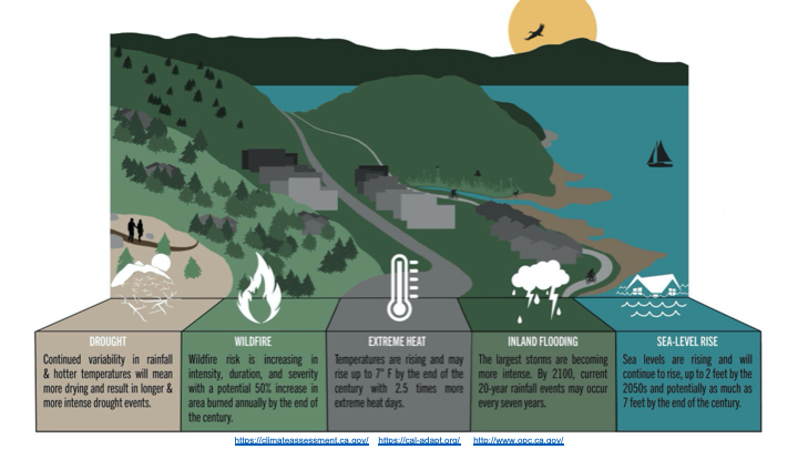
Since California’s last state-led climate change assessment in 2012, the Golden State has experienced a litany of natural disasters. This includes four years of severe drought from 2012 to 2016, an almost non-existent Sierra Nevada snowpack in 2014-2015 costing $2.1 billion in economic losses, widespread Bay Area flooding from winter 2017 storms, and extremely large and damaging wildfires culminating with this year’s Mendocino Complex fire achieving the dubious distinction of the largest in state history. California’s most recent climate assessment, released August 27th, predicts that for the state and the Bay Area, we can expect even more in the future.
The California state government first began assessing climate impacts formally in 2006, due to an executive order by Governor Schwarzenegger. California’s latest iteration and its fourth overall, includes a dizzying array of 44 technical reports; three topical studies on climate justice, tribal and indigenous communities, and the coast and ocean; as well as nine region-specific analyses.
The results are alarming for our state’s future: an estimated four to five feet of sea level rise and loss of one to two-thirds of Southern California beaches by 2100, a 50 percent increase in wildfires over 25,000 acres, stronger and longer heat waves, and infrastructure like airports, wastewater treatment plants, rail and roadways increasingly likely to suffer flooding.
For the first time, California’s latest assessment dives into climate consequences on a regional level. Academics representing nine California regions spearheaded research and summarized the best available science on the variable heat, rain, flooding and extreme event consequences for their areas. For example, the highest local rate of sea level rise in the state is at the rapidly subsiding Humboldt Bay. In San Diego county, the most biodiverse in all of California, preserving its many fragile and endangered species is an urgent priority. Francesca Hopkins from UC Riverside found that the highest rate of childhood asthma in the state isn’t an urban smog-filled city but in the Imperial Valley, where toxic dust from Salton Sea disaster chokes communities – and will only become worse as higher temperatures and less water due to climate change dry and brittle the area.
According to the Bay Area Regional Report, since 1950 the Bay Area has already increased in temperature by 1.7 degrees Fahrenheit and local sea level is eight inches higher than it was one hundred years ago. Future climate will render the Bay Area less suitable for our evergreen redwood and fir forests, and more favorable for tolerant chaparral shrub land. The region’s seven million people and $750 billion economy (almost one-third of California’s total) is predicted to be increasingly beset by more “boom and bust” irregular wet and very dry years, punctuated by increasingly intense and damaging storms.
Unsurprisingly, according to the report the Bay Area’s intensifying housing and equity problems have a multiplier affect with climate change. As Bay Area housing spreads further north, south, and inland the result is higher transportation and energy needs for those with the fewest resources available to afford them; and acute disparity in climate vulnerability across Bay Area communities and populations.
“All Californians will likely endure more illness and be at greater risk of early death because of climate change,” bluntly states the statewide summary brochure for California’s climate assessment. “[However] vulnerable populations that already experience the greatest adverse health impacts will be disproportionately affected.”
“We’re much better at being reactive to a disaster than planning ahead,” said UC Berkeley professor and contributing author David Ackerly at a California Adaptation Forum panel in Sacramento on August 27th. “And it is vulnerable communities that suffer from those disasters. How much human suffering has to happen before it triggers the next round of activity?”
The assessment’s data is publicly available online at “Cal-adapt,” where Californians can explore projected impacts for their neighborhoods, towns, and regions.


 The results are alarming for our state’s future: an estimated four to five feet of sea level rise and loss of one to two-thirds of Southern California beaches by 2100, a 50 percent increase in wildfires over 25,000 acres, stronger and longer heat waves, and infrastructure like airports, wastewater treatment plants, rail and roadways increasingly likely to suffer flooding.