Long insulated from severe risk by mild temperatures and the fog that regularly swaddles the Santa Cruz Mountains, San Mateo County now finds itself — like the rest of the Bay Area — facing the climate-driven prospect of catastrophic wildfire. The threat is leading one of the county’s largest landowners to devote unprecedented resources to fire-prevention efforts in the Peninsula Watershed — efforts that will also restore parts of the landscape to an approximation of their historical condition.
“In the last few years, the weather has changed in regards to the relative humidity,” says Fire Safe San Mateo County’s Denise Enea. “Normally you would go up to [the redwood-forested ridgeline at the edge of the watershed] and it would be kind of cold and misty. Now, you get out of the car and you reach for your sunglasses and your cap because it’s hot and it’s dry. And we’re also seeing much more wind.” The upshot, she says, is a noticeable increase in fire ignitions — including one in mid-May, much earlier in the year than normally expected. Thousands of homes occupying the area’s wildland-urban interface, including some of the region’s priciest properties, would be at risk in the event of a conflagration.
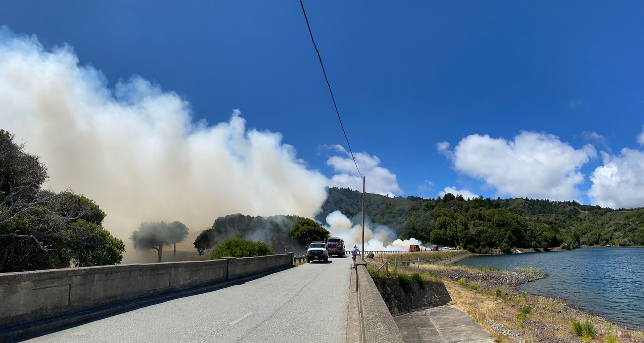
The changed weather, along with more frequent and extended droughts, is leading the San Francisco Public Utilities Commission (SFPUC), which owns approximately 23,000 acres of the upper watersheds of San Mateo Creek and Pilarcitos Creek, to double down on fire prevention efforts. “Last year we did more wildfire risk reduction work than any previous year,” says SFPUC’s Tim Ramirez, “and this year we’re going to do more than last year. We are removing hazardous trees that have died from drought and plant pathogens, expanding our fuel breaks, and getting at ladder fuels in the understory.”
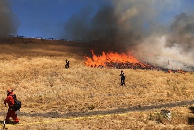
SFPUC is also working with Cal Fire on a new project that would allow the state agency to conduct additional prescribed burns in certain areas of the watershed. Traditionally Cal Fire conducts prescribed burns on San Andreas and Pilarcitos Dams (seven acres total); this year both were conducted on June 9.
Prescribed burn in June 2021 on San Andreas Dam. Photo: SFPUC
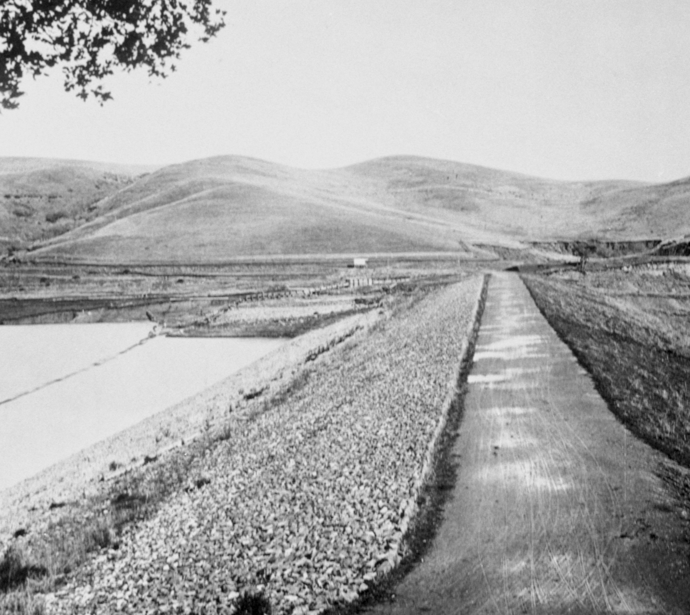
Ramirez notes that the heavy tree cover that blankets the watershed’s slopes is relatively new; before settlers arrived and began planting trees — many of them not native — on their farms and ranches, the area was largely grassland. To help guide its vegetation work, the SFPUC has commissioned a historical ecology report from the San Francisco Estuary Institute. “It gives us a bit of a glimpse of what the area used to look like,” says Ramirez, adding that the intent is not to recreate the past entirely. “But it helps us try to restore the biodiversity of the watershed at the same time we’re reducing some of the fuel loading and wildfire risk. We’re going to restore some of these grasslands and manage them that way in the future, not let the trees just come back.” The report is expected to be completed later this summer.
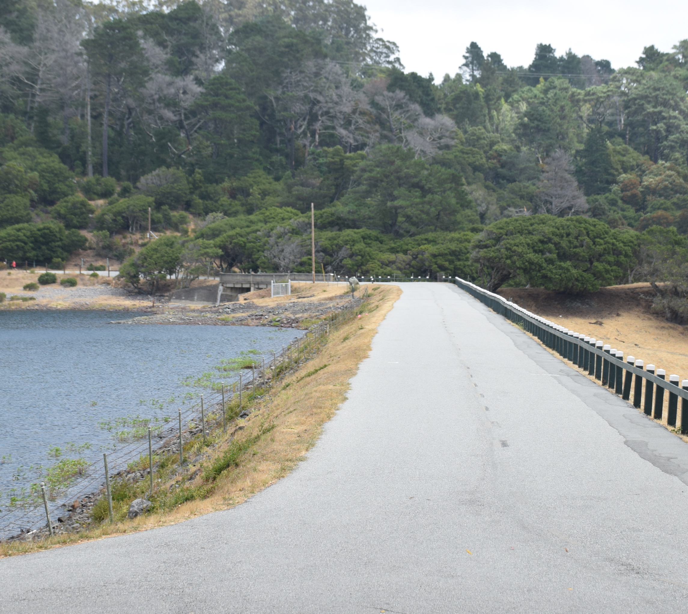
Grasslands behind San Andreas dam circa 1900, as compared to current tree cover. Photos: SFPUC
The SFPUC’s work is concentrated along its property boundaries and roadways, including the ridgeline next to Highway 35, which is also where, in May, the Commission approved a six-mile extension of the Bay Area Ridge Trail. “The ridgeline that runs through the watershed lands is a key connection for the Ridge Trail,” says Liz Westbrook of the Bay Area Ridge Trail Council. “We’ve been working on it with the SFPUC for more than 20 years.”
Although new public access to the watershed lands carries some risk — a careless hiker’s smoldering cigarette butt could ignite a fire, for example — Ramirez says that overall, the new trail will help protect the watershed. “It’s going to give us access to places we haven’t been able to get to before for emergency response.” He also notes that the docents who will patrol the trail, and the trail users themselves, can help spot and report small fires before they become big ones.
The SFPUC funds and conducts its own work on the Peninsula Watershed, and also supports and coordinates with other agencies, including Cal Fire; local fire protection districts; the Mid-Peninsula Open Space District, which has extensive holdings adjacent to the watershed; and Fire Safe SMC. Governor Newsom’s state budget for the year includes $2 billion for wildfire prevention; roughly half of it will be dedicated to vegetation management, including grants for local agencies to conduct forest health projects.
Cariad Hayes Thronson covers legal and political issues for Estuary News. She has served on the staffs of several national publications, including The American Lawyer. She is a long-time contributor to Estuary News, and some years ago served as its assistant editor. She lives in San Mateo with her husband and two children.
Our magazine’s media motto for many years has been “Where there’s an estuary, there’s a crowd.” The San Francisco Estuary is a place where people, wildlife, and commerce congregate, and where watersheds, rivers and the ocean meet and mix, creating a place of unusual diversity. In choosing to tell the...
Ever since the state and federal water projects were built in the 1930s and 1940s, California has captured snowmelt in foothill reservoirs, and moved the fresh water from dam releases and river outflows to parched parts of the state via aqueducts hundreds of miles long. A convoluted system of ancient...
Though the Clean Water Act did an amazing job of reducing wastewater and stormwater pollution of the San Francisco Estuary, some contaminants remain thorny problems. Legacy pollutants like mercury washed into the watershed from upstream gold mining, PCBs from old industrial sites, and selenium from agricultural drainage in the San...
Hothouse Earth
By Ariel Rubissow Okamoto
Photo by Megan Nguyen
Nothing could be stranger than sitting in the dark with thousands of suits and heels, watching a parade of promises to decarbonize from companies and countries large and small, reeling from the beauties of big screen rainforests and indigenous necklaces, and getting all choked up.
It was day two of the September 2018 Global Climate Action Summit in San Francisco when I felt it.
At first I wondered if I was simply starstruck. Most of us labor away trying to fix one small corner of the planet or another without seeing the likes of Harrison Ford, Al Gore, Michael Bloomberg, Van Jones, Jerry Brown – or the ministers or mayors of dozens of cities and countries – in person, on stage and at times angry enough to spit. And between these luminaries a steady stream of CEOs, corporate sustainability officers, and pension fund managers promising percentages of renewables and profits in their portfolios dedicated to the climate cause by 2020-2050.
I tried to give every speaker my full attention: the young man of Vuntut Gwichin heritage from the edge of the Yukon’s Arctic National Wildlife Refuge who pleaded with us not to enter his sacred lands with our drills and dependencies; all the women – swathed in bright patterns and head-scarfs – who kept punching their hearts. “My uncle in Uganda would take 129 years to emit the same amount of carbon as an American would in one year,” said Oxfam’s Winnie Byanyima.
“Our janitors are shutting off the lights you leave on,” said Aida Cardenas, speaking about the frontline workers she trains, mostly immigrants, who are excited to be part of climate change solutions in their new country.
The men on the stage, strutting about in feathers and pinstripes, spoke of hopes and dreams, money and power. “The notion that you can either do good or do well is a myth we have to collectively bust,” said New Jersey Governor Phil Murphy whose state is investing heavily in offshore wind farms.
“Climate change isn’t just about risks, it’s about opportunities,” said Blackrock sustainable investment manager Brian Deese.
But it wasn’t all these fine speeches that started the butterflies. Halfway through the second day of testimonials, it was a slight white-haired woman wrapped in an azure pashmina that pricked my tears. One minute she was on the silver screen with Alec Baldwin and the next she taking a seat on stage. She talked about trees. How trees can solve 30% of our carbon reduction problem. How we have to stop whacking them back in the Amazon and start planting them everywhere else. I couldn’t help thinking of Dr. Seuss and his truffala trees. Jane Goodall, over 80, is as fierce as my Lorax. Or my daughter’s Avatar.
Analyzing my take home feeling from the event I realized it wasn’t the usual fear – killer storms, tidal waves, no food for my kids to eat on a half-baked planet – nor a newfound sense of hope – I’ve always thought nature will get along just fine without us. What I felt was relief. People were actually doing something. Doing a lot. And there was so much more we could do.
As we all pumped fists in the dark, as the presentations went on and on and on because so many people and businesses and countries wanted to STEP UP, I realized how swayed I had let myself be by the doomsday news mill.
“We must be like the river, “ said a boy from Bangladesh named Risalat Khan, who had noticed our Sierra watersheds from the plane. “We must cut through the mountain of obstacles. Let’s be the river!”
Or as Harrison Ford less poetically put it: “Let’s turn off our phones and roll up our sleeves and kick this monster’s ass.”
4th California Climate Change Assessment Blues
by Isaac Pearlman
Since California’s last state-led climate change assessment in 2012, the Golden State has experienced a litany of natural disasters. This includes four years of severe drought from 2012 to 2016, an almost non-existent Sierra Nevada snowpack in 2014-2015 costing $2.1 billion in economic losses, widespread Bay Area flooding from winter 2017 storms, and extremely large and damaging wildfires culminating with this year’s Mendocino Complex fire achieving the dubious distinction of the largest in state history. California’s most recent climate assessment, released August 27th, predicts that for the state and the Bay Area, we can expect even more in the future.
The California state government first began assessing climate impacts formally in 2006, due to an executive order by Governor Schwarzenegger. California’s latest iteration and its fourth overall, includes a dizzying array of 44 technical reports; three topical studies on climate justice, tribal and indigenous communities, and the coast and ocean; as well as nine region-specific analyses.
The results are alarming for our state’s future: an estimated four to five feet of sea level rise and loss of one to two-thirds of Southern California beaches by 2100, a 50 percent increase in wildfires over 25,000 acres, stronger and longer heat waves, and infrastructure like airports, wastewater treatment plants, rail and roadways increasingly likely to suffer flooding.
For the first time, California’s latest assessment dives into climate consequences on a regional level. Academics representing nine California regions spearheaded research and summarized the best available science on the variable heat, rain, flooding and extreme event consequences for their areas. For example, the highest local rate of sea level rise in the state is at the rapidly subsiding Humboldt Bay. In San Diego county, the most biodiverse in all of California, preserving its many fragile and endangered species is an urgent priority. Francesca Hopkins from UC Riverside found that the highest rate of childhood asthma in the state isn’t an urban smog-filled city but in the Imperial Valley, where toxic dust from Salton Sea disaster chokes communities – and will only become worse as higher temperatures and less water due to climate change dry and brittle the area.
According to the Bay Area Regional Report, since 1950 the Bay Area has already increased in temperature by 1.7 degrees Fahrenheit and local sea level is eight inches higher than it was one hundred years ago. Future climate will render the Bay Area less suitable for our evergreen redwood and fir forests, and more favorable for tolerant chaparral shrub land. The region’s seven million people and $750 billion economy (almost one-third of California’s total) is predicted to be increasingly beset by more “boom and bust” irregular wet and very dry years, punctuated by increasingly intense and damaging storms.
Unsurprisingly, according to the report the Bay Area’s intensifying housing and equity problems have a multiplier affect with climate change. As Bay Area housing spreads further north, south, and inland the result is higher transportation and energy needs for those with the fewest resources available to afford them; and acute disparity in climate vulnerability across Bay Area communities and populations.
“All Californians will likely endure more illness and be at greater risk of early death because of climate change,” bluntly states the statewide summary brochure for California’s climate assessment. “[However] vulnerable populations that already experience the greatest adverse health impacts will be disproportionately affected.”
“We’re much better at being reactive to a disaster than planning ahead,” said UC Berkeley professor and contributing author David Ackerly at a California Adaptation Forum panel in Sacramento on August 27th. “And it is vulnerable communities that suffer from those disasters. How much human suffering has to happen before it triggers the next round of activity?”
The assessment’s data is publicly available online at “Cal-adapt,” where Californians can explore projected impacts for their neighborhoods, towns, and regions.


 The results are alarming for our state’s future: an estimated four to five feet of sea level rise and loss of one to two-thirds of Southern California beaches by 2100, a 50 percent increase in wildfires over 25,000 acres, stronger and longer heat waves, and infrastructure like airports, wastewater treatment plants, rail and roadways increasingly likely to suffer flooding.