Marsh restoration, Bay and Ridge Trail extensions, and urban park upgrades are among the types of projects eligible to receive funding through the 2019 Bay Area Priority Conservation Area (PCA) One Bay Area Grant Program. By March, aided by new mapping tools that can pinpoint regional landscape characteristics and needs, more than 36 cities, counties, agencies and non-profits had submitted letters of interest to the program, outlining a variety of projects that benefit one or more of the Bay Area’s 165 PCAs (see map opposite). Altogether, the grant requests totaled more than $19 million.
Some of these projects may help
vulnerable shoreline areas defend against sea level rise; others may make urban
hardscapes more porous under atmospheric river downpours; still others may
connect vital migratory corridors for urban wildlife through the skyscrapers,
industry, and neighborhoods of the metropolitan Bay Area.
“With this new stream of funding,
you could say we have a goal of both growing and conserving the region at the
same time,” says Matt Gerhart of the State Coastal Conservancy (SCC), which is
managing the grants.
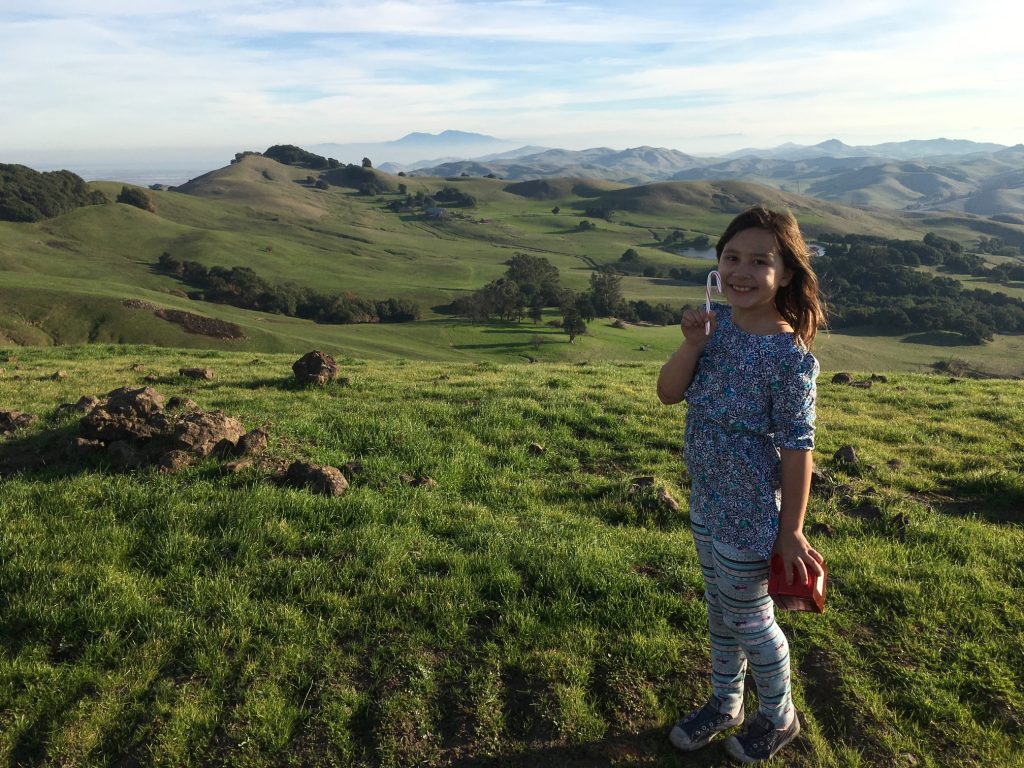
Along with Caltrans mitigation funds, a PCA grant helped the Napa Open Space District acquire 709 acres of the former Kirkland Ranch for the Suscol Headwaters preserve north of American Canyon (pictured here with young Napa resident). The parcel had been zoned for vineyards, and includes an outpost of coastal prairie. District General Manager John Woodbury says its 1505-foot high point offers “one of the most spectacular views of the North Bay.” Photo courtesy John Woodbury.
Important elements of the Plan Bay
Area 2040, the current integrated long-range transportation and land-use plan
for the region, PCAs are intended to complement areas designated for high-density
growth, or Priority Development Areas. “Compared to other Bay Area natural
lands, parks and preserves, the PCA network contributes a disproportionately
high number of some ecosystem services,” says Heather Dennis of the SF Bay
Conservation and Development Commission’s Adapting to Rising Tides (ART)
project.
PCAs, which are nominated by local
governments, agencies or non-profits, fall into four categories: natural
landscapes, agricultural land, regional recreation and urban greening. Some
PCAs fit more than one category, such as agricultural land that also provides
recreational opportunities.
The first list of PCAs was
assembled in 2008, when ABAG asked local interests and agencies around the Bay
to suggest unprotected places where pastures, forests, vacant lots, creeks, and
shorelines should be identified as a conservation priority. “Cities pushed back
on that approach, because anyone was allowed to submit an idea, and they felt
there was not enough consideration of existing municipal plans and priorities,”
says Laura Thompson, Assistant Planning Director for the Association of Bay
Area Governments (ABAG/MTC).
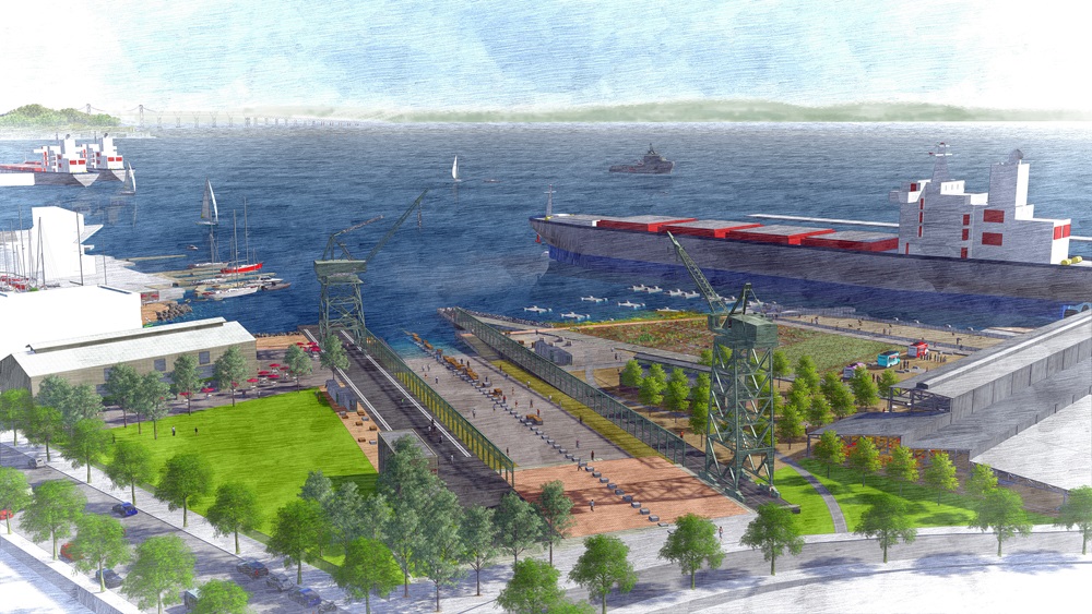
San Francisco’s bayshore is getting some badly needed public space as part of a PCA project at the site of the Union Iron Works shipyard at Pier 70. Here the Port of San Francisco is transforming ten acres into Crane Cove Park. “The park design accommodates projected sea level rise based upon the best available data during design development,” says Port project manager David Beaupre; much of the site has been elevated from three to nine feet. Plan courtesy Port of San Francisco
In the second round, cities were
placed in the drivers seat—as primary nominators of PCAs—and they were also
required to notify property owners of designations. A new category for PCAs of
“urban greening” was also added. “ The urban greening category is important,
because it creates opportunities for multi-benefit stormwater management
practices, like rain gardens, and active transportation improvements, such as
bike and pedestrian trails along greenway corridors,” says the San Francisco
Estuary Partnership’s John Bradt. “These projects promote public awareness of
resource protection, and public access to nature within built environment.”
In terms of the money to support
these PCAs, the first round of PCA grants funded 23 projects around the Bay in
2013, ranging from recreational improvements to Mill Valley’s Bayfront Park to
the purchase of 174 acres adjacent to San Mateo County’s Memorial Park for open
space and recreation. Funds awarded totaled $12 million. In the second round, now underway, the
Metropolitan Transportation Commission (MTC) and the Coastal Conservancy have
set aside $10 million for projects in the Peninsula, Southern and East Bay
counties (the North Bay program is managed separately by local transportation
agencies; in the second round of those grants, 11 projects were awarded a total
of $8.2 million).
Projects eligible for funding
during the current grant round must consist of at least one of five activities,
within or adjacent to, a PCA: protection or enhancement of nature resources, open
space or agricultural lands; pedestrian and bicycle facilities, urban greening;
planning activities; and visual enhancements. After reviewing the letters of
interest, regional agencies will invite selected projects to submit a full
proposal by July.
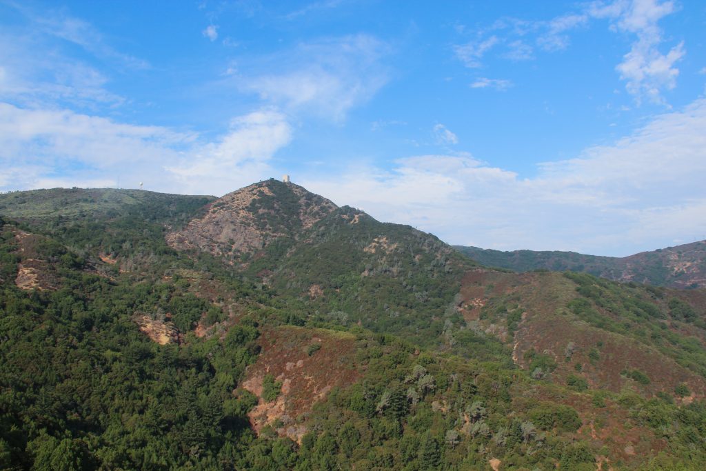
The Midpeninsula Regional Open Space District recently approved a cultural conservation easement in Santa Clara County’s Sierra Azul PCA that gives the Amah Mutsun Tribal Band access to the 3486-foot-high summit of Mount Umunhum for ceremonial use and growing traditionally significant plants. Photo: MROSD
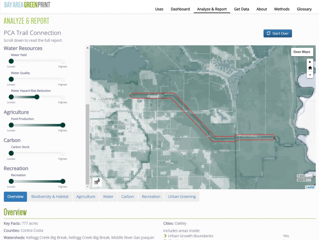
As part of the application
process, PCA grant applicants must submit a project report through Bay Area
Greenprint. This mapping and data tool was developed by the Greenbelt Alliance,
the Nature Conservancy, the Bay Area Open Space Council, the American Farmland
Trust and the Green Info Network. A Greenprint report identifies, maps and
measures ecosystem values, and allows users to visually display and share a
range of data about their project location—everything from its status as
habitat for protected species to agricultural and recreational uses to carbon
sequestering potential.
“The Greenprint allows you to see
where within a PCA are the conservation priorities,” says Adam Garcia of
Greenbelt Alliance, who gave a quick onscreen lesson in how to navigate the
tool’s colorful and attractive menus at several recent workshops for grant
applicants. “It can offer a snapshot of what’s in your project area right now
and a way to assess multiple benefits, but it’s not a scenario planning tool.”
“The Greenprint helps us identify
the highest priorities for conservation, based on values that we have all
agreed on,” says Tom Robinson of the Bay Area Open Space Council. “No matter
who is evaluating the projects, [we now have] a standard way to view them.”
Sample Greenprint output.
Given the investment in PCA
projects, figuring out how to protect them from the effects of climate change,
and leverage them to protect other assets, is a priority. With funding from
MTC, BCDC’s ART Bay Area program conducted vulnerability assessments of 19 PCAs
around the Bay in 2018. Among the findings was that more than 50 percent of the
recreation that the PCA network provides, and all of the PCAs that are critical
for coastal protection, are vulnerable to sea level rise and flooding. Findings
also compared ecosystem services provided by PCAs across the region using
ecosystem valuation models developed by the Natural Capital Project, a
collaboration between Stanford University, University of Minnesota, the World
Wildlife Fund, and the Nature Conservancy.
“We are hoping that this analysis
will help guide where future PCAs make sense, and also how projects within
existing PCAs might speak to the vulnerabilities that we’ve identified,” says
BCDC’s Dennis. For example, the PCA
around Oakland’s Damon Slough has wetlands that may provide flood protection to
the Coliseum area PDA, as well as nearby transportation infrastructure. Next,
ART will examine issues such as what adaptation strategies might make PCAs more
resilient, and whether rising sea levels warrant changes in how PCAs are
designated and funded.
Critical priority conservation areas (PCAs) across ecosystem services and their exposure to sea level rise (darker colors represent the relative importance
of each PCA for each ecosystem service). PCAs with multiple color blocks are important across more services. This chart shows: over 50% of
recreation is vulnerable; of those the top 25 rec PCAs, 13 are vulnerable to SLR; these 13 provide nearly 50% of visitation within the network. Habitat
PCAs vulnerability to SLR, over 10% of ridgeway habitat is exposed, nearly 25% of snowy plover habitat, 20% of agricultural land, less than 10% vernal
pools, and the majority of marsh. Source: BCDC ART 2019
“The ART analysis isn’t intended
to dictate how the PCA program operates, or whether there should be a change in
our regional approach to natural lands, “ says the ART program’s new director
Dana Brechwald. “That’s a bigger conversation. This analysis could help us
think about a regional approach in new ways.”
The PCA program has evolved to
more effectively balance Bay Area-wide priorities, says The Nature
Conservancy’s Liz O’Donoghue. “There will always be tension between locally
identified, locally driven priorities, which is really how on-the-ground
conservation is most successful, and the need for local conservation priorities
and projects to support and be driven by regional priorities, so you can get to
landscape-scale conservation.”
“We’re not there yet, in terms of
adding another layer of regional analysis to the locally-driven PCA designation
process, but we will be taking a new look at the PCA-PDA balance next year
through MTC’s Horizons and scenario development program. Staff are still
discussing all this internally, but given all the pressures in the region for
growth, climate adaptation, and ecosystem services, being more strategic could
pay off,” says ABAG/MTC’s Thompson.
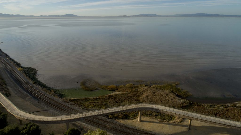
Bay Trail link funded by PCA program on the Pinole Point Shoreline. Photo courtesy EBRPD.
Whether and where additional PCAs
will be designated are questions to be answered in Plan Bay Area 2050, which is
slated to be released in 2021. “In the months ahead we will be working to
update our growth framework, which might include an opportunity for new PCAs to
be submitted and considered,” says MTC’s Dave Vautin. “We’ve been working
closely with the ART Bay Area team over the last year as we start preparing for
PBA2050,” he says.
The Nature Conservancy’s
O’Donoghue is bullish on the future of the PCA program. “It supports the Bay
Area’s vision for growth and reflects the importance of conservation in the
area, as well as MTC’s and SCC’s innovation in figuring out how the local and
regional connect and support each other. I think its just getting better and
better.”
Cariad Hayes Thronson covers legal and political issues for Estuary News. She has served on the staffs of several national publications, including The American Lawyer. She is a long-time contributor to Estuary News, and some years ago served as its assistant editor. She lives in San Mateo with her husband and two children.
Our magazine’s media motto for many years has been “Where there’s an estuary, there’s a crowd.” The San Francisco Estuary is a place where people, wildlife, and commerce congregate, and where watersheds, rivers and the ocean meet and mix, creating a place of unusual diversity. In choosing to tell the...
Ever since the state and federal water projects were built in the 1930s and 1940s, California has captured snowmelt in foothill reservoirs, and moved the fresh water from dam releases and river outflows to parched parts of the state via aqueducts hundreds of miles long. A convoluted system of ancient...
Though the Clean Water Act did an amazing job of reducing wastewater and stormwater pollution of the San Francisco Estuary, some contaminants remain thorny problems. Legacy pollutants like mercury washed into the watershed from upstream gold mining, PCBs from old industrial sites, and selenium from agricultural drainage in the San...
Hothouse Earth
By Ariel Rubissow Okamoto
Photo by Megan Nguyen
Nothing could be stranger than sitting in the dark with thousands of suits and heels, watching a parade of promises to decarbonize from companies and countries large and small, reeling from the beauties of big screen rainforests and indigenous necklaces, and getting all choked up.
It was day two of the September 2018 Global Climate Action Summit in San Francisco when I felt it.
At first I wondered if I was simply starstruck. Most of us labor away trying to fix one small corner of the planet or another without seeing the likes of Harrison Ford, Al Gore, Michael Bloomberg, Van Jones, Jerry Brown – or the ministers or mayors of dozens of cities and countries – in person, on stage and at times angry enough to spit. And between these luminaries a steady stream of CEOs, corporate sustainability officers, and pension fund managers promising percentages of renewables and profits in their portfolios dedicated to the climate cause by 2020-2050.
I tried to give every speaker my full attention: the young man of Vuntut Gwichin heritage from the edge of the Yukon’s Arctic National Wildlife Refuge who pleaded with us not to enter his sacred lands with our drills and dependencies; all the women – swathed in bright patterns and head-scarfs – who kept punching their hearts. “My uncle in Uganda would take 129 years to emit the same amount of carbon as an American would in one year,” said Oxfam’s Winnie Byanyima.
“Our janitors are shutting off the lights you leave on,” said Aida Cardenas, speaking about the frontline workers she trains, mostly immigrants, who are excited to be part of climate change solutions in their new country.
The men on the stage, strutting about in feathers and pinstripes, spoke of hopes and dreams, money and power. “The notion that you can either do good or do well is a myth we have to collectively bust,” said New Jersey Governor Phil Murphy whose state is investing heavily in offshore wind farms.
“Climate change isn’t just about risks, it’s about opportunities,” said Blackrock sustainable investment manager Brian Deese.
But it wasn’t all these fine speeches that started the butterflies. Halfway through the second day of testimonials, it was a slight white-haired woman wrapped in an azure pashmina that pricked my tears. One minute she was on the silver screen with Alec Baldwin and the next she taking a seat on stage. She talked about trees. How trees can solve 30% of our carbon reduction problem. How we have to stop whacking them back in the Amazon and start planting them everywhere else. I couldn’t help thinking of Dr. Seuss and his truffala trees. Jane Goodall, over 80, is as fierce as my Lorax. Or my daughter’s Avatar.
Analyzing my take home feeling from the event I realized it wasn’t the usual fear – killer storms, tidal waves, no food for my kids to eat on a half-baked planet – nor a newfound sense of hope – I’ve always thought nature will get along just fine without us. What I felt was relief. People were actually doing something. Doing a lot. And there was so much more we could do.
As we all pumped fists in the dark, as the presentations went on and on and on because so many people and businesses and countries wanted to STEP UP, I realized how swayed I had let myself be by the doomsday news mill.
“We must be like the river, “ said a boy from Bangladesh named Risalat Khan, who had noticed our Sierra watersheds from the plane. “We must cut through the mountain of obstacles. Let’s be the river!”
Or as Harrison Ford less poetically put it: “Let’s turn off our phones and roll up our sleeves and kick this monster’s ass.”
4th California Climate Change Assessment Blues
by Isaac Pearlman
Since California’s last state-led climate change assessment in 2012, the Golden State has experienced a litany of natural disasters. This includes four years of severe drought from 2012 to 2016, an almost non-existent Sierra Nevada snowpack in 2014-2015 costing $2.1 billion in economic losses, widespread Bay Area flooding from winter 2017 storms, and extremely large and damaging wildfires culminating with this year’s Mendocino Complex fire achieving the dubious distinction of the largest in state history. California’s most recent climate assessment, released August 27th, predicts that for the state and the Bay Area, we can expect even more in the future.
The California state government first began assessing climate impacts formally in 2006, due to an executive order by Governor Schwarzenegger. California’s latest iteration and its fourth overall, includes a dizzying array of 44 technical reports; three topical studies on climate justice, tribal and indigenous communities, and the coast and ocean; as well as nine region-specific analyses.
The results are alarming for our state’s future: an estimated four to five feet of sea level rise and loss of one to two-thirds of Southern California beaches by 2100, a 50 percent increase in wildfires over 25,000 acres, stronger and longer heat waves, and infrastructure like airports, wastewater treatment plants, rail and roadways increasingly likely to suffer flooding.
For the first time, California’s latest assessment dives into climate consequences on a regional level. Academics representing nine California regions spearheaded research and summarized the best available science on the variable heat, rain, flooding and extreme event consequences for their areas. For example, the highest local rate of sea level rise in the state is at the rapidly subsiding Humboldt Bay. In San Diego county, the most biodiverse in all of California, preserving its many fragile and endangered species is an urgent priority. Francesca Hopkins from UC Riverside found that the highest rate of childhood asthma in the state isn’t an urban smog-filled city but in the Imperial Valley, where toxic dust from Salton Sea disaster chokes communities – and will only become worse as higher temperatures and less water due to climate change dry and brittle the area.
According to the Bay Area Regional Report, since 1950 the Bay Area has already increased in temperature by 1.7 degrees Fahrenheit and local sea level is eight inches higher than it was one hundred years ago. Future climate will render the Bay Area less suitable for our evergreen redwood and fir forests, and more favorable for tolerant chaparral shrub land. The region’s seven million people and $750 billion economy (almost one-third of California’s total) is predicted to be increasingly beset by more “boom and bust” irregular wet and very dry years, punctuated by increasingly intense and damaging storms.
Unsurprisingly, according to the report the Bay Area’s intensifying housing and equity problems have a multiplier affect with climate change. As Bay Area housing spreads further north, south, and inland the result is higher transportation and energy needs for those with the fewest resources available to afford them; and acute disparity in climate vulnerability across Bay Area communities and populations.
“All Californians will likely endure more illness and be at greater risk of early death because of climate change,” bluntly states the statewide summary brochure for California’s climate assessment. “[However] vulnerable populations that already experience the greatest adverse health impacts will be disproportionately affected.”
“We’re much better at being reactive to a disaster than planning ahead,” said UC Berkeley professor and contributing author David Ackerly at a California Adaptation Forum panel in Sacramento on August 27th. “And it is vulnerable communities that suffer from those disasters. How much human suffering has to happen before it triggers the next round of activity?”
The assessment’s data is publicly available online at “Cal-adapt,” where Californians can explore projected impacts for their neighborhoods, towns, and regions.


 The results are alarming for our state’s future: an estimated four to five feet of sea level rise and loss of one to two-thirds of Southern California beaches by 2100, a 50 percent increase in wildfires over 25,000 acres, stronger and longer heat waves, and infrastructure like airports, wastewater treatment plants, rail and roadways increasingly likely to suffer flooding.