San Francisco Bay has seven highway bridges with tolls, eight if you count the span linking Antioch to the Delta. In the future it just might have nine. The latest candidate is not the long-debated Southern Crossing, but rather a series of causeways carrying California’s single most vulnerable road in the era of sea-level rise: State Route 37 between Vallejo and Novato.
A bridge on dry land? But the dryness of this region is a fading illusion. Over a century ago, dikes, pumps, and fill transformed a 50,000-acre wetland wilderness into a fabric of fields and managed ponds—for a geological blink of an eye. Now the tides are returning, in a process partly planned and partly inevitable. In the name of habitat, something like half of the old wetlands along this arc have been reopened to the Bay, with much more to come.
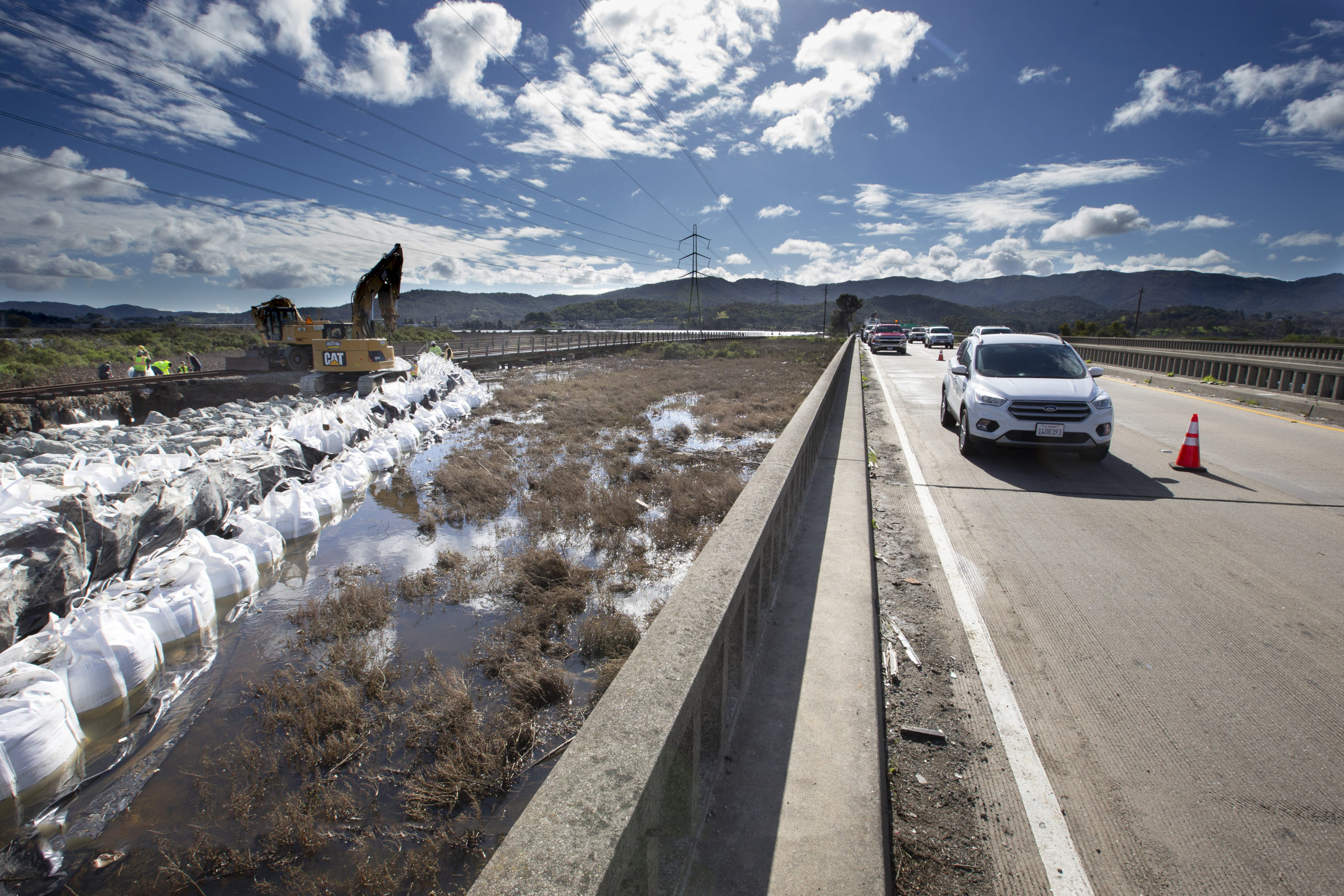
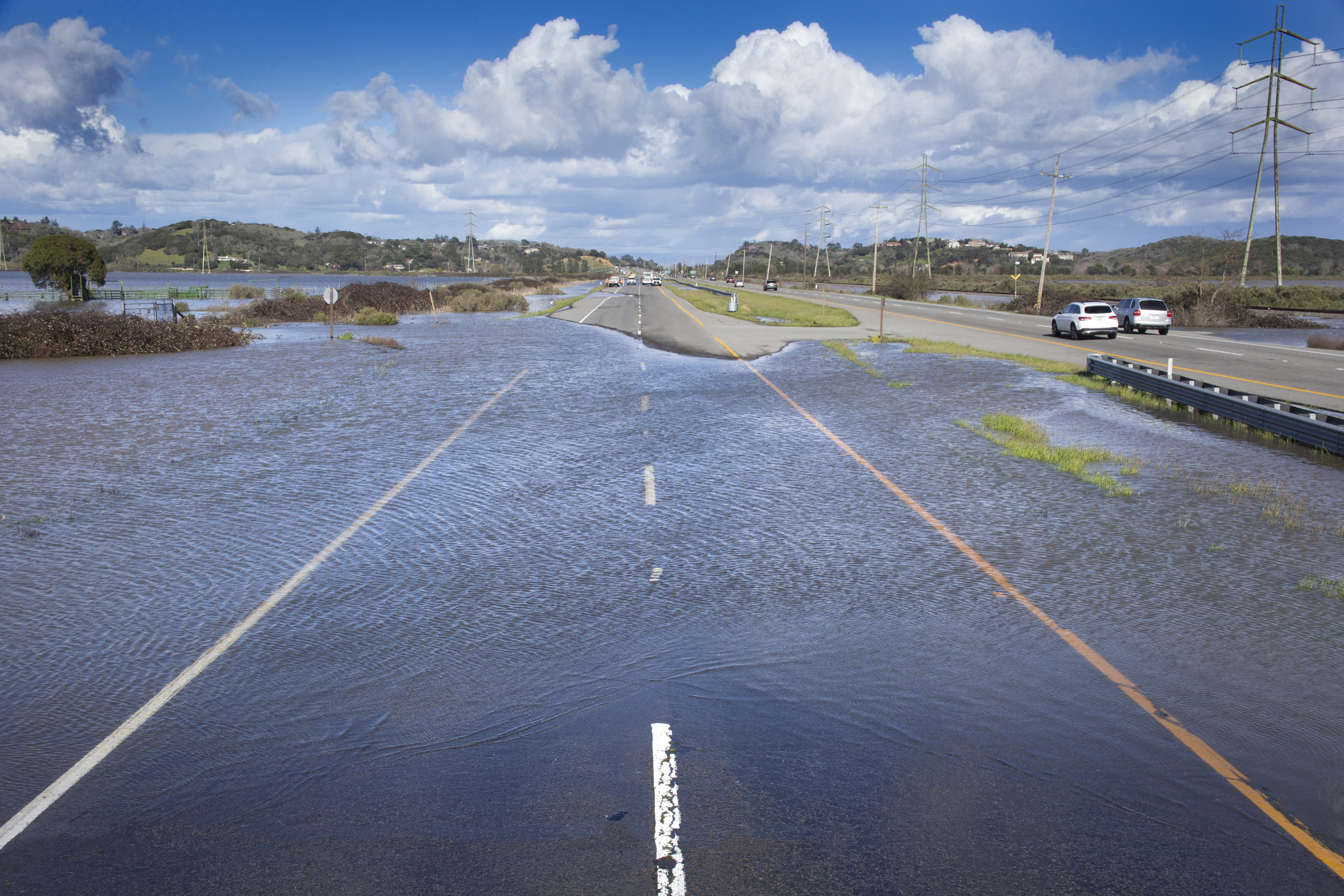
Elsewhere, pumps labor to keep the water out of fields that have sunk as much as seven feet below sea level. At some points the asphalt of Highway 37 lies no more than two feet above typical daily tide levels. In the wet winters of 2017 and 2019, the low points flooded for weeks at a time. While the nine miles from Vallejo to Sears Point feel most exposed, the western reach in Marin has proved especially inundation-prone.
Throw into this hydrophilic situation the factor of sea-level rise: over a foot by 2050 and three feet by 2100, to pluck mid-range numbers from the State’s latest complex table of probabilities. With each revision, the estimates nudge upwards. Ten feet of rise by century’s end is quite possible. Storm surges and peak runoff will add to the pressure at times. And the encroachment won’t stop at a convenient cut-off date. Based on the record of past warm periods, a 2015 paper in Science suggested, the total accumulated rise could be twenty feet or more.
Recent flooding on State Route 37. Photo: Caltrans/John Huseby
From head-on collisions in the 1980s to crippling congestion now, Highway 37 is a familiar headache for highway engineers. The focus on its very survival dates to 2010. In that year the Federal Highway Administration and the California Department of Transportation chose this road for one of the first studies ever on roads and sea-level rise. Study lead Fraser Shilling of the Road Ecology Center at UC Davis credits two Caltrans workers, Katie Benouar and Kome Ajise, for wrangling this unusual support of long-distance planning by agencies sometimes accused of limited vision. “This whole field has moved forward in leaps because of champions [like these],” says Shilling.
As the Davis team wrapped up its SR 37 Integrated Traffic, Infrastructure and Sea Level Rise Analysis,the initiative passed to the local level. In 2015, the counties along or near the route—Solano, Napa, Sonoma, and Marin—joined the Metropolitan Transportation Commission and Caltrans in a Highway 37 Policy Committee. Fearing that engineers might not take full account of the vast marsh restorations underway in the area, the Sonoma Land Trust, the Coastal Conservancy, and others joined in a State Route 37-Baylands Group. In 2017, the group laid down markers: Whatever is done with the east-west highway must also improve the passage of tides and stormwaters north and south, not further impede those flows.
This statement was more than just advice. The Baylands Group spoke for powerful players along the route, notably the state and federal wildlife agencies and the Sonoma Land Trust. It had the backing of the Environmental Protection Agency and the regional water board. And it had arithmetic on its side. It was only by factoring in a lot of environmental improvement that any major retrofit could pencil out economically; without the “green” factor, its cost-benefit ratio would fall below one, a Caltrans make-or-break metric.
In fact the highway planners readily accepted that they must do two things at once: preserve and improve an overburdened transportation link, and support the great North Bay wetlands project. While they were at it, they also undertook to find a place for the Bay Trail and to make life easier for the many workers who commute from Vallejo to Marin. “It’s much more joined-up thinking than we’ve had in the past,” says Jeremy Lowe of the San Francisco Estuary Institute.
What is now called the Resilient 37 program has weighed the options for the short term, and the long. The uncontroversial early steps are aimed at relieving congestion. The two-lane stretch between Vallejo and Sears Point will likely be reconfigured to offer one or two additional lanes; a traffic circle will smooth the difficult intersection of 37 and northbound Highway 121 near the Infineon Raceway. But all such works are for a generation only.
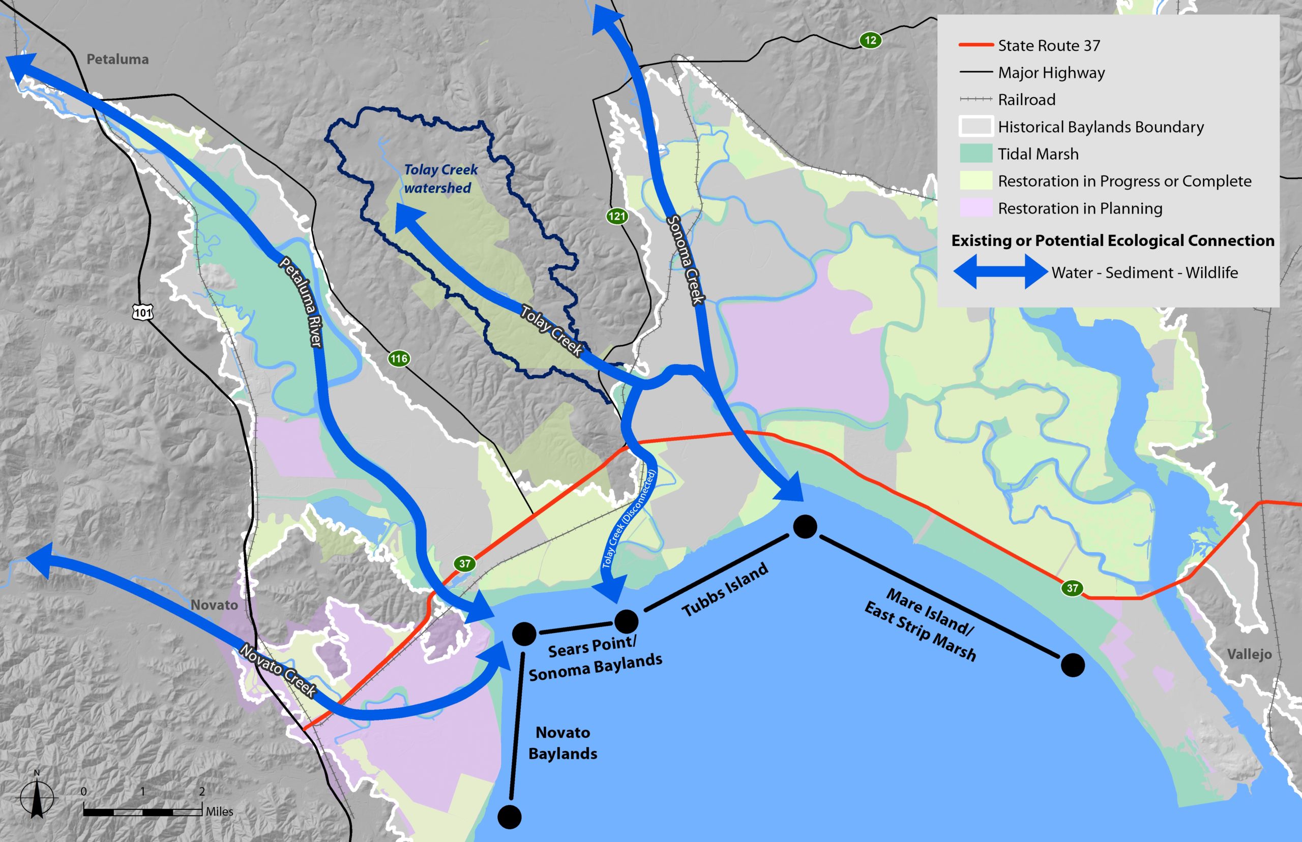
The long-term options are much more varied, debatable, and costly. Three bights of the Baylands must be traversed or circumvented: a small one around Novato Creek, a larger one east of the Petaluma River, and a vast one between Sears Point and the Napa River.
Ecological connectivity is an important thing to maintain and improve as part of any update to the highway. Map: SFEI
The cheapest fix in each case would be to raise the road on much wider embankments, putting maximum barriers in the way of natural flows. The most dramatic would be to build a straight-line over-water bridge between Novato and Vallejo. The most circuitous would be to shift the highway northward, at least in the eastern reach, skirting the largest lobe of the marshy realm.
But the option that has floated to the top in analysis and stakeholder conversations is to leave the road roughly where it is but elevate it on pilings for many long stretches, making it something like the Yolo Causeway that carries Interstate 80 into Sacramento.
Because causeways would damage the marshes less than the present road, it is suggested, the projects might not have to spin off funds for compensating habitat improvements. The work could be “self-mitigating.” “The wetlands could do what they need to do,” says Jessica Davenport of the Coastal Conservancy, “and the road would be out of harm’s way.”
The apparent drift toward the maximal causeway option arouses one dissent worth noting: from Fraser Shilling, lead author of the UC Davis study that started this ball rolling. In 2017, he and Steven Moore, then a member of the State Water Resources Control Board, wrote an op-ed suggesting more attention to the northern route. “Acknowledging that today we would never build a costly highway through sensitive tidal marshes, [we could] move the transportation function inland and off the marshes altogether.”
Shilling feels the same today. He questions Resilient 37’s initial conclusion that the northern path would do more harm than the southern. “I think an honest appraisal of environmental impacts would bring [the northern route] to the front. The marshes will suffer under the causeway option.” As for cost, Shilling finds incredible the conclusion that skirting the marsh would be pricier than crossing it. Among other things, he points out, these estimates assume that the “new” 37 must start and end exactly where the “old” one does.
The arguments on costs and impacts will continue for a while. “There really is no perfect solution,” says SFEI’s Lowe.
Alternate routes explored for Highway 37 improvements. Map: Aecom
The next step is to firm up plans for the western reach of the road, from US 101 to State Route 121, called Segment A. The Metropolitan Transportation begins a “design alternative assessment” this month; Caltrans will gear up its CEQA process soon after. Attention will then turn to the near-term improvements for Segment B, from 121 to Mare Island. The ultimate vision for this problematic stretch will take longer to confirm. “Timing will be dependent on funding,” says Stefanie Hom of the Metropolitan Transportation Commission (MTC)..
Besides the highway, two other transportation lines have claims on planners’ attention in the San Pablo Baylands: the Bay Trail and the railroad. Along these northern shores the Bay Trail is largely an aspirational dotted line, but Sonoma County has a genuine hiking and cycling path almost from border to border. One segment makes a loop around Tubbs Island; the second follows a new levee in the Sears Point Wetlands Restoration Project. A gap of less than a mile separates the two. In the near term, advocates want to forge this missing link. The voids in Solano County and Marin County will be more challenging to fill. In the long-term, the trail might evade rising waters to the north, or wind up bundled in alongside causeways. If offset from or sunk lower than the traffic lanes, the path could still be a pleasant walk or ride.
A rail line, now used only for freight, runs from Novato to Suisun City, where it joins the Capitol Corridor Amtrak route. The tracks parallel Highway 37 in Segment A from Novato to Sears Point and then swing north near the marsh edge, passing south of Sonoma and Napa on their way east. The California State Rail Plan of 2018 foresees passenger service on this route, and Sonoma-Marin Rapid Transit, which owns much of the line, is interested in providing it someday.
Though not so vulnerable as the road, the tracks, too, will eventually have to be elevated or shifted in the face of sea-level rise. In their present location, they also complicate restoration projects; the need to protect them limited marsh expansion at Sears Point. Again, the long-term solution is to combine the highway and the railroad in one corridor. (And what about the far-out possibility of retaining the railroad only?) These fundamental issues seem to be beyond the scope of the current planning.
Which brings us to the massive question all acknowledge and no one yet can answer: where does the money come from? The maximum causeway option, by the latest estimate, would cost about $3.5 billion. Vital though it is, Highway 37 seems to be no one’s burning priority. And there are so many other claims. The MTC noted in January: “For this east-west connection, the proposed resilience project [has] higher costs and lower benefits than other transportation facilities requiring protection from rising sea levels.”
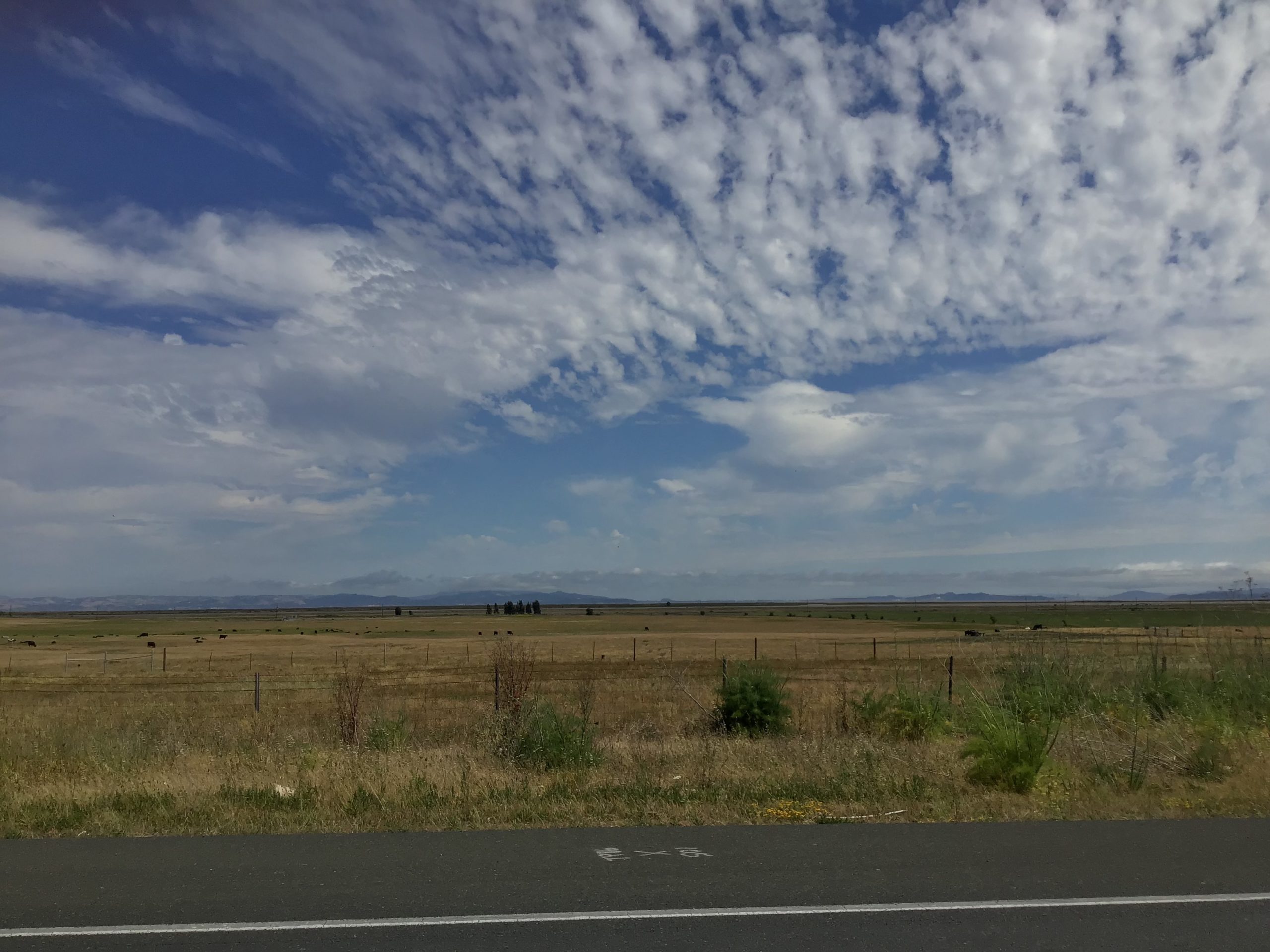
It is easy to imagine the hayfields on either side of Highway 37 as former baylands. Photo: Ariel Okamoto
To stand a chance in the race for funds, the highway must pay part of its own way. This spring, before the coronavirus scrambled priorities, Senator Bill Dodd of Napa introduced legislation to make it a toll road. (This would turn back the clock: the route first opened, in 1928, as a private turnpike.) A $5 or $6 toll, Dodd estimates, could yield $650 million over twenty years. That is a far cry from $3.5 billion, but it would certainly cover interim work and serve as a lever to pry loose larger blocks of funding from the state and, above all, the feds. “If people really want to do this,” says the Coastal Conservancy’s Davenport, “there’s always a way.”
In the current health and financial crisis, it has to be said, the way seems longer than ever before. It is a special case of a general problem. As the Bay Area girds for sea-level rise, the initial question is: What would it take to save everything? What can we do, we ask, to protect this neighborhood, this road, that bridge, this stadium, this waterfront? The Resilient by Design competition brought out many attractive partial solutions, including the bold “Grand Bayway” vision for the San Pablo Baylands. The prevailing mood is: yes, we can do it, if we are smart, if we are quick, and if we can raise colossal sums. It is surely good, as a thought experiment, to test out a policy of minimal retreat.
But—especially if the more pessimistic estimates of sea-level rise prove correct—brutal facts are going to force a triage. Is letting go of an asset like 37 out of the question? “We cannot abandon it,” says Sonoma Supervisor Susan Gorin firmly. Consultant Doug Wallace, formerly of EBMUD, offers another view. “When circumstances force our hand,” he says, “we will think previously unthinkable thoughts.”
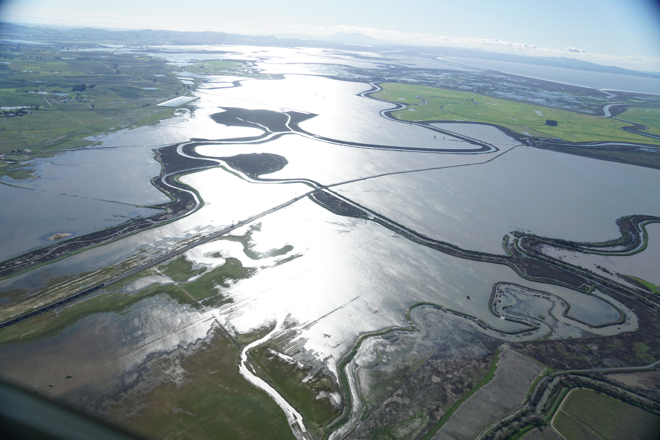
Sonoma Creek north of the confluence with Tolay Creek, with San Francisco Bay at top right. Photo courtesy Sonoma Land Trust
Spotlight on Sonoma Creek
The diking and draining of the San Pablo Baylands began 150 years ago and peaked in the 1980s. The long journey back began in 1994, with a tiny restoration on the Petaluma River, called “Carl’s Marsh” for its champion, Carl Wilcox of the California Department of Fish and Wildlife. The success of that small project led to big and then bigger ones—and to a vision for a vast new wetland system.
The latest piece of that vision is the Sonoma Creek Baylands Strategy, due for release in June. Developed by the Sonoma Land Trust, it is funded in large part by the San Francisco Bay Restoration Authority through 2016’s Measure AA. The U.S. Fish and Wildlife Service, the Resources Legacy Fund, and the Dolby Family Fund have pitched in as well.
The strategy addresses lands along the lower course of Sonoma Creek that are still behind dikes and largely in private ownership. This terrain is the next frontier for restoration, as funds become available and property owners find themselves ready to sell. “Willing landowners, the SR 37 redesign, and the pressure of climate change set the stage for this study,” says Kendall Webster of the Trust.
The emerging preferred alternative calls for restoring some 5,000 additional acres of marsh and rerouting Tolay Creek so that it flows directly into the Bay instead of joining Sonoma Creek. By separating the two creeks, the plan will reduce the flood peaks on Sonoma Creek and postpone the day when a key bridge on Highway 37 has to be lengthened and raised.
That highway—together with the Bay Trail and a railroad line owned by Sonoma-Marin Rail Transit—looms large in the thinking of restoration planners. Agnostic about the details of routing, the Sonoma Creek Baylands Strategy underlines the need to get infrastructure out of the way of water movement, and favors “co-location” of the three transportation lines. Could transportation budgets ultimately help fund the restorations, by way of mitigation for the impacts inevitably caused? “That’s the unicorn we’re pursuing,” Webster says.
John Hart is an environmental journalist and author of sixteen books and several hundred other published works. He is also the winner of the James D. Phelan Award, the Commonwealth Club Medal in Californiana, and the David R. Brower Award for Service in the Field of Conservation. For ESTUARY, he writes on groundwater, infrastructure, and California water politics and history.
Our magazine’s media motto for many years has been “Where there’s an estuary, there’s a crowd.” The San Francisco Estuary is a place where people, wildlife, and commerce congregate, and where watersheds, rivers and the ocean meet and mix, creating a place of unusual diversity. In choosing to tell the...
Ever since the state and federal water projects were built in the 1930s and 1940s, California has captured snowmelt in foothill reservoirs, and moved the fresh water from dam releases and river outflows to parched parts of the state via aqueducts hundreds of miles long. A convoluted system of ancient...
Though the Clean Water Act did an amazing job of reducing wastewater and stormwater pollution of the San Francisco Estuary, some contaminants remain thorny problems. Legacy pollutants like mercury washed into the watershed from upstream gold mining, PCBs from old industrial sites, and selenium from agricultural drainage in the San...
Hothouse Earth
By Ariel Rubissow Okamoto
Photo by Megan Nguyen
Nothing could be stranger than sitting in the dark with thousands of suits and heels, watching a parade of promises to decarbonize from companies and countries large and small, reeling from the beauties of big screen rainforests and indigenous necklaces, and getting all choked up.
It was day two of the September 2018 Global Climate Action Summit in San Francisco when I felt it.
At first I wondered if I was simply starstruck. Most of us labor away trying to fix one small corner of the planet or another without seeing the likes of Harrison Ford, Al Gore, Michael Bloomberg, Van Jones, Jerry Brown – or the ministers or mayors of dozens of cities and countries – in person, on stage and at times angry enough to spit. And between these luminaries a steady stream of CEOs, corporate sustainability officers, and pension fund managers promising percentages of renewables and profits in their portfolios dedicated to the climate cause by 2020-2050.
I tried to give every speaker my full attention: the young man of Vuntut Gwichin heritage from the edge of the Yukon’s Arctic National Wildlife Refuge who pleaded with us not to enter his sacred lands with our drills and dependencies; all the women – swathed in bright patterns and head-scarfs – who kept punching their hearts. “My uncle in Uganda would take 129 years to emit the same amount of carbon as an American would in one year,” said Oxfam’s Winnie Byanyima.
“Our janitors are shutting off the lights you leave on,” said Aida Cardenas, speaking about the frontline workers she trains, mostly immigrants, who are excited to be part of climate change solutions in their new country.
The men on the stage, strutting about in feathers and pinstripes, spoke of hopes and dreams, money and power. “The notion that you can either do good or do well is a myth we have to collectively bust,” said New Jersey Governor Phil Murphy whose state is investing heavily in offshore wind farms.
“Climate change isn’t just about risks, it’s about opportunities,” said Blackrock sustainable investment manager Brian Deese.
But it wasn’t all these fine speeches that started the butterflies. Halfway through the second day of testimonials, it was a slight white-haired woman wrapped in an azure pashmina that pricked my tears. One minute she was on the silver screen with Alec Baldwin and the next she taking a seat on stage. She talked about trees. How trees can solve 30% of our carbon reduction problem. How we have to stop whacking them back in the Amazon and start planting them everywhere else. I couldn’t help thinking of Dr. Seuss and his truffala trees. Jane Goodall, over 80, is as fierce as my Lorax. Or my daughter’s Avatar.
Analyzing my take home feeling from the event I realized it wasn’t the usual fear – killer storms, tidal waves, no food for my kids to eat on a half-baked planet – nor a newfound sense of hope – I’ve always thought nature will get along just fine without us. What I felt was relief. People were actually doing something. Doing a lot. And there was so much more we could do.
As we all pumped fists in the dark, as the presentations went on and on and on because so many people and businesses and countries wanted to STEP UP, I realized how swayed I had let myself be by the doomsday news mill.
“We must be like the river, “ said a boy from Bangladesh named Risalat Khan, who had noticed our Sierra watersheds from the plane. “We must cut through the mountain of obstacles. Let’s be the river!”
Or as Harrison Ford less poetically put it: “Let’s turn off our phones and roll up our sleeves and kick this monster’s ass.”
4th California Climate Change Assessment Blues
by Isaac Pearlman
Since California’s last state-led climate change assessment in 2012, the Golden State has experienced a litany of natural disasters. This includes four years of severe drought from 2012 to 2016, an almost non-existent Sierra Nevada snowpack in 2014-2015 costing $2.1 billion in economic losses, widespread Bay Area flooding from winter 2017 storms, and extremely large and damaging wildfires culminating with this year’s Mendocino Complex fire achieving the dubious distinction of the largest in state history. California’s most recent climate assessment, released August 27th, predicts that for the state and the Bay Area, we can expect even more in the future.
The California state government first began assessing climate impacts formally in 2006, due to an executive order by Governor Schwarzenegger. California’s latest iteration and its fourth overall, includes a dizzying array of 44 technical reports; three topical studies on climate justice, tribal and indigenous communities, and the coast and ocean; as well as nine region-specific analyses.
The results are alarming for our state’s future: an estimated four to five feet of sea level rise and loss of one to two-thirds of Southern California beaches by 2100, a 50 percent increase in wildfires over 25,000 acres, stronger and longer heat waves, and infrastructure like airports, wastewater treatment plants, rail and roadways increasingly likely to suffer flooding.
For the first time, California’s latest assessment dives into climate consequences on a regional level. Academics representing nine California regions spearheaded research and summarized the best available science on the variable heat, rain, flooding and extreme event consequences for their areas. For example, the highest local rate of sea level rise in the state is at the rapidly subsiding Humboldt Bay. In San Diego county, the most biodiverse in all of California, preserving its many fragile and endangered species is an urgent priority. Francesca Hopkins from UC Riverside found that the highest rate of childhood asthma in the state isn’t an urban smog-filled city but in the Imperial Valley, where toxic dust from Salton Sea disaster chokes communities – and will only become worse as higher temperatures and less water due to climate change dry and brittle the area.
According to the Bay Area Regional Report, since 1950 the Bay Area has already increased in temperature by 1.7 degrees Fahrenheit and local sea level is eight inches higher than it was one hundred years ago. Future climate will render the Bay Area less suitable for our evergreen redwood and fir forests, and more favorable for tolerant chaparral shrub land. The region’s seven million people and $750 billion economy (almost one-third of California’s total) is predicted to be increasingly beset by more “boom and bust” irregular wet and very dry years, punctuated by increasingly intense and damaging storms.
Unsurprisingly, according to the report the Bay Area’s intensifying housing and equity problems have a multiplier affect with climate change. As Bay Area housing spreads further north, south, and inland the result is higher transportation and energy needs for those with the fewest resources available to afford them; and acute disparity in climate vulnerability across Bay Area communities and populations.
“All Californians will likely endure more illness and be at greater risk of early death because of climate change,” bluntly states the statewide summary brochure for California’s climate assessment. “[However] vulnerable populations that already experience the greatest adverse health impacts will be disproportionately affected.”
“We’re much better at being reactive to a disaster than planning ahead,” said UC Berkeley professor and contributing author David Ackerly at a California Adaptation Forum panel in Sacramento on August 27th. “And it is vulnerable communities that suffer from those disasters. How much human suffering has to happen before it triggers the next round of activity?”
The assessment’s data is publicly available online at “Cal-adapt,” where Californians can explore projected impacts for their neighborhoods, towns, and regions.


 The results are alarming for our state’s future: an estimated four to five feet of sea level rise and loss of one to two-thirds of Southern California beaches by 2100, a 50 percent increase in wildfires over 25,000 acres, stronger and longer heat waves, and infrastructure like airports, wastewater treatment plants, rail and roadways increasingly likely to suffer flooding.