Chris Rose likens a 500-acre farm in the northwest Delta to a bakery in downtown Manhattan. Each property has obvious characteristics that would be hard to replace. In the Delta it’s some of the best water rights available and land that isn’t so subsided and salty you can’t grow good grass. In Manhattan, it’s the chance to bake and sell comfort food in the heart of a city with a big appetite. Each property is prime real estate in terms of ‘location, location, location’ and each has intangible values to the families or communities that have long made a living from them.
“Most people might look at those farms and just see cattle grazing and think that’s easy to do somewhere else, but it’s not that simple, ” says Rose, executive director of the Solano Resource Conservation District.
Anyone who’s been around debates about the Delta’s highest and best uses for decades has seen a long train of plans touting this or that kind of restoration to save salmon, smelt, mice, birds and other endangereds. What’s different about the San Francisco Estuary Institute’s recently released Delta Renewed guide is that it finally puts all that’s been learned together in one place in a mere 100 pages. Using science-based maps and metrics, it offers a strategic approach to ecosystem restoration in a landscape where thousands of acres of historic marsh have been reduced to a few hundred to make way for crops, cows, and people.
Recent flooding on McCormick Williamson Tract. Photo: Judah Grossman, TNC
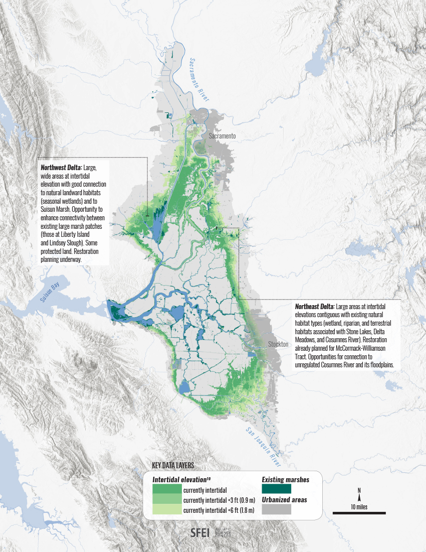
The guide divides the Delta into five major zones and recommends different tactics for different regions. In this context, guide co-author Julie Beagle will tell you that those 500-1,000-acre cow and sheep farms in the northwest Delta are valuable for a reason other than just location. For those scouting the Delta for places to replant riverbanks, restore marshes, and grow fish food, it’s elevation, elevation, elevation that’s the biggest draw.
“The Delta is not a blank slate,” says Beagle, an environmental scientist. “You can engineer almost anything anywhere. But there are only a few places where we can use the power of flows, tides, floods, erosion, and sediment movement to repair and renew habitats. In our guide, we’ve suggested what to look for and do when you find it.”
Some areas of the Delta, like the middle, are so sunk into a deep bowl below sea level that breaching any levee to reintroduce tidal action would simply result in new lakes filled with bass from Mississippi and weeds from Brazil. But on the periphery of the Delta, particularly on the northwest edge around Cache Slough and the northeast edge around the lower Cosumnes River, the landscapes are less subsided and more amenable to what Beagle calls “process-based” restoration.
“It really matters where in the landscape you are,” says Beagle. “We can’t go back to the historical Delta, but the bones are still there in terms of some of the geologic and hydrologic processes at work on the earth’s surface. Opportunities still exist to reboot these processes and connect patches of habitat, we just have to do the right things in the right places.”
The Right Places in the Right Sizes
When state and federal agencies began talking in the late 1990s about 90,000 acres of restoration in the Delta to rescue the most endangered species, it must have sounded like a lot to those who live, work and farm in this landscape. In a Delta of 500-700,000 acres, including the areas covered by water, that’s a hefty chunk. The truth is these targets didn’t amount to much over the years, however. Many planned restoration projects have been stuck between shifting permit requirements and political priorities for decades. Today’s targets are more modest than those of decades past.
Under Eco-Restore, the state’s most recent effort to advance ecosystem restoration and meet the basic requirements of various biological opinions and endangered species authorizations, targets include 10,000 acres of tidal, riparian and upland habitat restoration, an area about twice the size of San Francisco International Airport, as well as large areas of floodplain enhancement and subsidence reversal projects, according to State Fish and Wildlife’s Carl Wilcox.
DeltaRenewed, SFEI’s tidal marsh strategies
Along with the targets comes the need for local input into where and how these revived landscapes might best fit among the current pastures, rice fields, orchards and homesteads of the Delta. “Finding the sweet spot between effective restoration and agricultural sustainability and flood protection is the collaborative task ahead of us,” says the Delta Conservancy’s Campbell Ingram. “We are just beginning to engage counties and landowners in what promises to be a really rich conversation.”
That conversation will be informed by both the Delta Renewed guide and a bigger picture state framework for conservation due later this year. Both will be the subject of ongoing workshops and outreach efforts organized by the Conservancy.
“Farmers want to be part of creating the vision, they don’t want scientists doing their own thing without taking into account agricultural values,” says Ingram.
“It all goes back to working with the locals,” says Wilcox, who is in the midst of weaving stakeholder concerns into the state’s forthcoming Delta Conservation Framework. “We’re trying to produce a document they see themselves in,” he says.
Two Promising Locations
for Nature-Based Engineering
While landowners have long pointed out that the state should be restor ing public property first, before asking farmers to take one for the team, both approaches may be necessary in an increasingly uncertain future.
DeltaRenewed, SFEI’s tidal-marsh restoration map
“The scales we’ve been working on haven’t been big enough to sustain both the species we care about and the processes that create their food and habitat,” says Julie Beagle. To both create and maintain habitats, she says, we have to use the flow of water and sediment — nature’s habitat builders — and innovative engineering to connect larger landscapes.
Two areas of the Delta are now emerging as the proving grounds for what the Delta Renewed team has in mind, as well as for connecting actions on both public and private property, whether it’s growing bird-friendly crops or marshes. Insiders refer to these areas as the ‘arc’ and the ‘corridor.’
The ‘arc,’ a term and a place first identified by UC Davis’s Peter Moyle in earlier searches for good fish habitat, encompasses the lands around Cache Slough in the northwest Delta. If strategic spots on private lands in and around the slough were connected to the already habitat-rich public lands in Suisun Marsh and Yolo Bypass, the area could form an arc in both in shape and purpose. Much like the refugees on Noah’s Ark, this may be the last place various near-extinct fish species might survive, with a little help from humans.
The ‘corridor’ is a swath of river preserves and islands running from the northeast corner of the Delta at the mouth of the Cosumnes River out to sea. With recent purchases of several Delta islands by Southern California’s Metropolitan Water District, a connected series of habitats mostly on “public” lands, but also including wildlife-friendly farms, suddenly seems doable.
“This winter’s flood fight, when the Nature Conservancy had to work with state Water Resources and other neighbors in the northeast Delta area on their common problem of managing high flows, shows the potential for collaboration in the corridor,” says Wilcox.
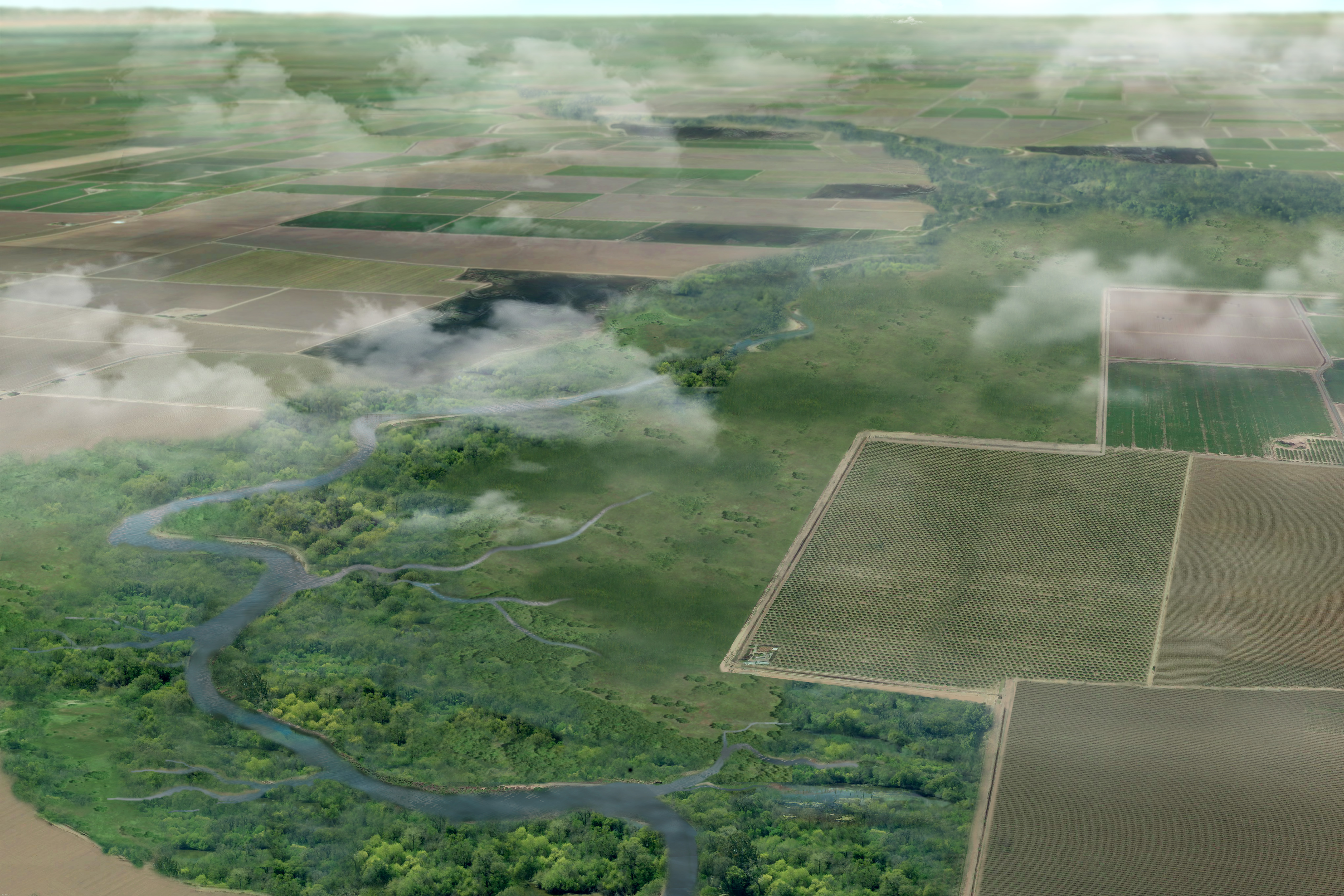
Idealized rendering of a renewed future in the South Delta where farms and riparian zones both have room to thrive. Source SFEI.
The buzz on the corridor is still in its infancy, but conversations about Cache Slough and the arc are farther along. The most recent push has involved five meetings organized by the Delta Conservancy and cautious conversations and negotiations.
“Having state agencies, reclamation districts, and counties representing farming interests all sitting in the same room and discussing what to do in the Cache Slough area is somewhat of a victory,” says Chris Rose.
One recent outcome is Delta Conservancy funding for Solano County agencies to work with federal advisors to evaluate and assess the land’s agricultural and other values and uses (LESA program). The idea is to know more about what’s being grown where and the location of supporting infrastructure such as crop processing facilities and water intakes before laying it over the new ecological opportunity maps.
Everyone then hopes landowners would actually come to the table and consider the on-the-ground synergies they might find on combined maps. In the past, a good turn out might have only come in protest of some new regulatory threat of takings. In the future, Rose, Ingram and Wilcox are doing their darndest to set up a more collaborative pathway to decision-making.
“It isn’t as if farmers don’t want habitats or don’t like the idea straight away,” says Rose. “It’s that it has to fit into their business. When you get a breakthrough, it’s because they want to see more raptors, or more songbirds, or that they’re not really using some piece of their land much anyway. It’s painful and it’s slow but I don’t know how else you can do it. Occasionally you hit a wall and there has to be some compromise to move forward.”
Compromises could also come from the sheer length of time required to achieve beneficial change. “When farmers hear ‘marsh restoration’ they often think ‘land conversion’, but restoration won’t happen overnight, there will be interim landscapes,” says Beagle. “It’s an evolving process, as sea level and groundwater rises, a particular farm could begin by engaging with wildlife friendly agricultural practices, then transition to different crops and habitats, and later allow some marsh restoration once the tides get too high. Our approach takes the long view — it’s a 50-100 year timeline.”
In the meantime, Ingram hopes that by tying funding for some of these activities to the Delta Renewed guide and the state’s Delta Conservation Framework they’ll get more traction. Under Proposition 1, the Delta Conservancy has $50 million and the Department of Fish and Wildlife $87 million to invest in restoration. “When we’re soliciting proposals, we’re going to direct people to those documents and ask them if they’re incorporating the concepts in project level design,” he says.
The Prop 1 bankroll isn’t much of a carrot for Cache Slough farmers sitting on golden water rights and good grass, however. Fifty years ago they could have found a similar property elsewhere but nearby, just as Santa Clara Valley farmers moved to the Central Valley to make way for Silicon Valley. Today there are fewer choices.
“Without being able to offer similar property or a lot more money, it can be a hard sell,” says Rose.
But outright purchase isn’t the only option on the table for those who hope to promote restoration. “Just because it’s a wetland, doesn’t mean the state has to own it,” says Ingram.
Science That Primes the Pump
In today’s climate of short-term thinking and alternate realities, it is heartening to note the amount of painstaking effort and “fact-checking” that went into A Delta Renewed. It’s the last of three reports from the San Francisco Estuary Institute funded by the State Department of Fish and Wildlife with bond funds approved by voters for this purpose. The first report investigated the historical ecology of the Delta, and the second how humans changed it. This final guide is crammed with to do lists and detailed dissections of Delta geography and land uses, all based on the foundation of research that went before. This is science that allows people in the field — whether farmers, fisheries managers, wetland designers, or water engineers — to get on with the business of repairing and renewing the landscape confident that they now know enough to proceed.
“I remember well when we were all struggling with what the “natural” Delta must have been like, and whether there was more or less water going through it than now,” says US Geological Survey climate scientist Mike Dettinger. “As I look at various important research papers just published, I believe that our ability to articulate what our species need, how the various water, sediment, and nutrient budgets of the Delta have changed, and what the missing elements of the Delta are today, has benefited immensely from the effort that culminated in A Delta Renewed. We cannot understand what is right in front of us without understanding where it all came from.”
Even if carried out on a serious scale, the recommendations in A Delta Renewed may not be enough to save every species from extinction (see archive.estuarynews.org/orphans). But they could help get some of the natural processes necessary to sustain a healthy ecosystem going again, and thus support some native species. And they could help move water, mud, and fish through the Delta in ways less damaging to local communities, economies, and riverbanks than what we’ve witnessed below Oroville Dam post the most recent atmospheric river downpours.
Fifty years from now, if natural processes are still functional and science-based stewardship continues, there will still be birds to watch, ducks to hunt, and fish to catch. Whatever the reason we’re trying to save them, or the location or elevation, it’s a recipe for greatness that might actually have legs.
Ariel Rubissow Okamoto is both today’s editor-in-chief and the founding editor of ESTUARY magazine (1992-2001). She enjoys writing in-depth, silo-crossing stories about water, restoration, and science. She’s a co-author of a Natural History of San Francisco Bay (UC Press 2011), frequent contributor of climate change stories to Bay Nature magazine, and occasional essayist for publications like the San Francisco Chronicle (see her Portfolio here). In other lives, she has been a vintner, soccer mom, and waitress. She lives in San Francisco close to the Bay with her architect husband Paul Okamoto.
Our magazine’s media motto for many years has been “Where there’s an estuary, there’s a crowd.” The San Francisco Estuary is a place where people, wildlife, and commerce congregate, and where watersheds, rivers and the ocean meet and mix, creating a place of unusual diversity. In choosing to tell the...
Ever since the state and federal water projects were built in the 1930s and 1940s, California has captured snowmelt in foothill reservoirs, and moved the fresh water from dam releases and river outflows to parched parts of the state via aqueducts hundreds of miles long. A convoluted system of ancient...
Though the Clean Water Act did an amazing job of reducing wastewater and stormwater pollution of the San Francisco Estuary, some contaminants remain thorny problems. Legacy pollutants like mercury washed into the watershed from upstream gold mining, PCBs from old industrial sites, and selenium from agricultural drainage in the San...
Hothouse Earth
By Ariel Rubissow Okamoto
Photo by Megan Nguyen
Nothing could be stranger than sitting in the dark with thousands of suits and heels, watching a parade of promises to decarbonize from companies and countries large and small, reeling from the beauties of big screen rainforests and indigenous necklaces, and getting all choked up.
It was day two of the September 2018 Global Climate Action Summit in San Francisco when I felt it.
At first I wondered if I was simply starstruck. Most of us labor away trying to fix one small corner of the planet or another without seeing the likes of Harrison Ford, Al Gore, Michael Bloomberg, Van Jones, Jerry Brown – or the ministers or mayors of dozens of cities and countries – in person, on stage and at times angry enough to spit. And between these luminaries a steady stream of CEOs, corporate sustainability officers, and pension fund managers promising percentages of renewables and profits in their portfolios dedicated to the climate cause by 2020-2050.
I tried to give every speaker my full attention: the young man of Vuntut Gwichin heritage from the edge of the Yukon’s Arctic National Wildlife Refuge who pleaded with us not to enter his sacred lands with our drills and dependencies; all the women – swathed in bright patterns and head-scarfs – who kept punching their hearts. “My uncle in Uganda would take 129 years to emit the same amount of carbon as an American would in one year,” said Oxfam’s Winnie Byanyima.
“Our janitors are shutting off the lights you leave on,” said Aida Cardenas, speaking about the frontline workers she trains, mostly immigrants, who are excited to be part of climate change solutions in their new country.
The men on the stage, strutting about in feathers and pinstripes, spoke of hopes and dreams, money and power. “The notion that you can either do good or do well is a myth we have to collectively bust,” said New Jersey Governor Phil Murphy whose state is investing heavily in offshore wind farms.
“Climate change isn’t just about risks, it’s about opportunities,” said Blackrock sustainable investment manager Brian Deese.
But it wasn’t all these fine speeches that started the butterflies. Halfway through the second day of testimonials, it was a slight white-haired woman wrapped in an azure pashmina that pricked my tears. One minute she was on the silver screen with Alec Baldwin and the next she taking a seat on stage. She talked about trees. How trees can solve 30% of our carbon reduction problem. How we have to stop whacking them back in the Amazon and start planting them everywhere else. I couldn’t help thinking of Dr. Seuss and his truffala trees. Jane Goodall, over 80, is as fierce as my Lorax. Or my daughter’s Avatar.
Analyzing my take home feeling from the event I realized it wasn’t the usual fear – killer storms, tidal waves, no food for my kids to eat on a half-baked planet – nor a newfound sense of hope – I’ve always thought nature will get along just fine without us. What I felt was relief. People were actually doing something. Doing a lot. And there was so much more we could do.
As we all pumped fists in the dark, as the presentations went on and on and on because so many people and businesses and countries wanted to STEP UP, I realized how swayed I had let myself be by the doomsday news mill.
“We must be like the river, “ said a boy from Bangladesh named Risalat Khan, who had noticed our Sierra watersheds from the plane. “We must cut through the mountain of obstacles. Let’s be the river!”
Or as Harrison Ford less poetically put it: “Let’s turn off our phones and roll up our sleeves and kick this monster’s ass.”
4th California Climate Change Assessment Blues
by Isaac Pearlman
Since California’s last state-led climate change assessment in 2012, the Golden State has experienced a litany of natural disasters. This includes four years of severe drought from 2012 to 2016, an almost non-existent Sierra Nevada snowpack in 2014-2015 costing $2.1 billion in economic losses, widespread Bay Area flooding from winter 2017 storms, and extremely large and damaging wildfires culminating with this year’s Mendocino Complex fire achieving the dubious distinction of the largest in state history. California’s most recent climate assessment, released August 27th, predicts that for the state and the Bay Area, we can expect even more in the future.
The California state government first began assessing climate impacts formally in 2006, due to an executive order by Governor Schwarzenegger. California’s latest iteration and its fourth overall, includes a dizzying array of 44 technical reports; three topical studies on climate justice, tribal and indigenous communities, and the coast and ocean; as well as nine region-specific analyses.
The results are alarming for our state’s future: an estimated four to five feet of sea level rise and loss of one to two-thirds of Southern California beaches by 2100, a 50 percent increase in wildfires over 25,000 acres, stronger and longer heat waves, and infrastructure like airports, wastewater treatment plants, rail and roadways increasingly likely to suffer flooding.
For the first time, California’s latest assessment dives into climate consequences on a regional level. Academics representing nine California regions spearheaded research and summarized the best available science on the variable heat, rain, flooding and extreme event consequences for their areas. For example, the highest local rate of sea level rise in the state is at the rapidly subsiding Humboldt Bay. In San Diego county, the most biodiverse in all of California, preserving its many fragile and endangered species is an urgent priority. Francesca Hopkins from UC Riverside found that the highest rate of childhood asthma in the state isn’t an urban smog-filled city but in the Imperial Valley, where toxic dust from Salton Sea disaster chokes communities – and will only become worse as higher temperatures and less water due to climate change dry and brittle the area.
According to the Bay Area Regional Report, since 1950 the Bay Area has already increased in temperature by 1.7 degrees Fahrenheit and local sea level is eight inches higher than it was one hundred years ago. Future climate will render the Bay Area less suitable for our evergreen redwood and fir forests, and more favorable for tolerant chaparral shrub land. The region’s seven million people and $750 billion economy (almost one-third of California’s total) is predicted to be increasingly beset by more “boom and bust” irregular wet and very dry years, punctuated by increasingly intense and damaging storms.
Unsurprisingly, according to the report the Bay Area’s intensifying housing and equity problems have a multiplier affect with climate change. As Bay Area housing spreads further north, south, and inland the result is higher transportation and energy needs for those with the fewest resources available to afford them; and acute disparity in climate vulnerability across Bay Area communities and populations.
“All Californians will likely endure more illness and be at greater risk of early death because of climate change,” bluntly states the statewide summary brochure for California’s climate assessment. “[However] vulnerable populations that already experience the greatest adverse health impacts will be disproportionately affected.”
“We’re much better at being reactive to a disaster than planning ahead,” said UC Berkeley professor and contributing author David Ackerly at a California Adaptation Forum panel in Sacramento on August 27th. “And it is vulnerable communities that suffer from those disasters. How much human suffering has to happen before it triggers the next round of activity?”
The assessment’s data is publicly available online at “Cal-adapt,” where Californians can explore projected impacts for their neighborhoods, towns, and regions.


 The results are alarming for our state’s future: an estimated four to five feet of sea level rise and loss of one to two-thirds of Southern California beaches by 2100, a 50 percent increase in wildfires over 25,000 acres, stronger and longer heat waves, and infrastructure like airports, wastewater treatment plants, rail and roadways increasingly likely to suffer flooding.